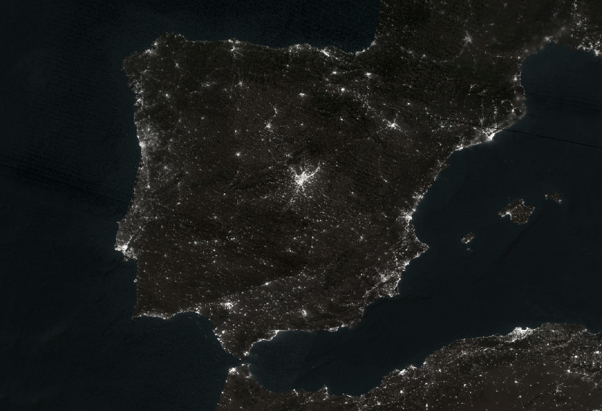
Last night's nighttime view of Spain/Portugal before their power outage. (VIIRS Day/Night Band)
#viirs
Tokyo seen on VIIRS DNB Nighttime Imagery on Feb 11, 2025. That city sure has a lot of light! #Tokyo #RemoteImaging #VIIRS
Public service announcement:
Data from #VIIRS DNB since the summer is affected by an instrumental effect, which makes the data from the last few months darker than they should be (see e.g. this graph for Manhattan). The #NASA #BlackMarble team is working to fix it.
ht to Damien Guiraudie who wrote to me to ask what was going on, and also to Zhuosen Wang from @NASA who quickly responded to my question.
#LightPollution #RemoteSensing #EarthObservation #NighttimeLights #PSA
[lance-modis] Unavailability of SNPP L2+ EDR data products until further notice -- Update
Fuel For Hurricane Milton [remotesensing, NASA]
--
https://earthobservatory.nasa.gov/images/153429/fuel-for-hurricane-milton <-- shared technical article
--
https://weather.ndc.nasa.gov/sport/ <-- shared link to NASA SPoRT page
--
#GIS #spatial #mapping #HurricanMilton #hurricanemilton2024 #HurricaneWarning #hurricane #extremeweather #remotesensing #climatechange #ocean #oceantemperatures #temperatures #Florida #GulfOfMexico #seasurfacetemperatures #risk #hazard #storm #stormsurge #flooding #wind #SPoRT #VIIRS #spatialanalysis #spatiotemporal #weather #weatherforecasting #satellite #global #coast #coastal #nowCOAST #disaster #naturaldisaster #naturalhazard #prediction #mitigation #planning #management #cost #economy
@nasa
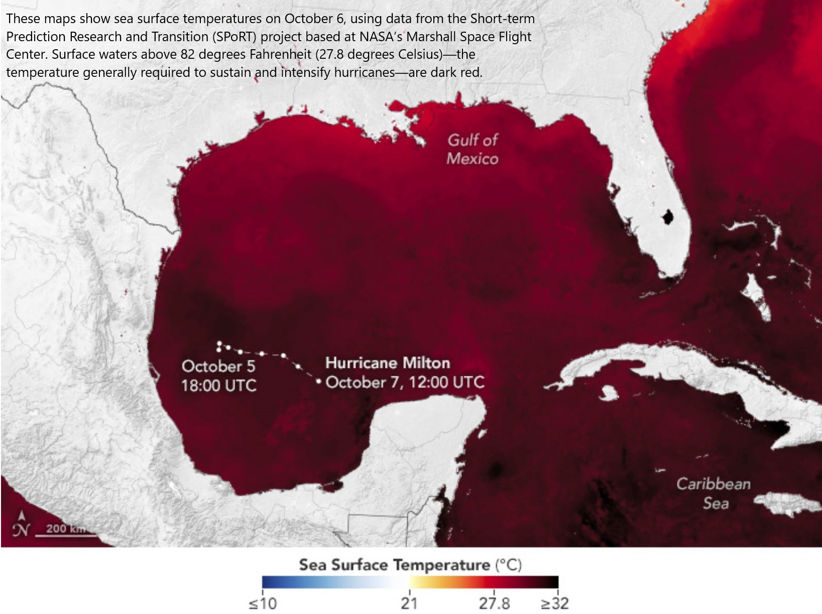
![map - These maps show sea surface temperatures on October 6, using data from the Short-term Prediction Research and Transition (SPoRT) project based at NASA’s Marshall Space Flight Center. Surface waters above 82 degrees Fahrenheit (27.8 degrees Celsius)—the temperature generally required to sustain and intensify hurricanes—are dark red. This map... is [also] overlaid with brightness temperature data, acquired by the VIIRS (Visible Infrared Imaging Radiometer Suite) on the NOAA-21 satellite in the early morning of October 7, to show the location of Milton’s storm clouds.](https://files.mastodon.social/cache/media_attachments/files/113/278/740/956/680/315/original/93a8948a122471bf.jpg)
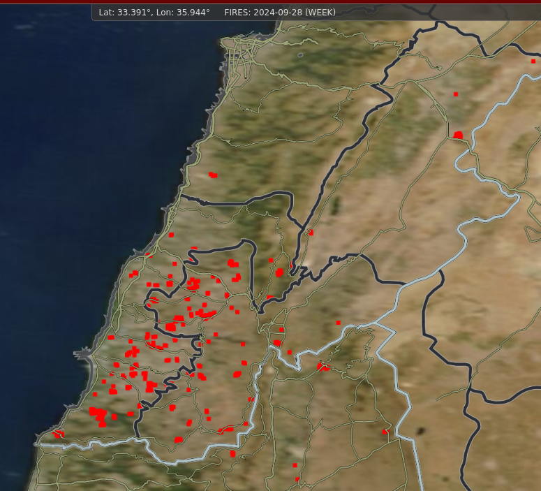
Hmm, satellite hotspots in Southern Lebanon over the last 7 days 👀 #Lebanon #RemoteImaging #VIIRS #MODIS
#NASA hat mit dem #GEOS-Modell eine beeindruckende globale Karte des #CO2-Ausstoßes erstellt. Das hochauflösende #Wettermodell nutzt #Supercomputer und Milliarden von Datenpunkten, um atmosphärische Ereignisse wie #Stürme und #Wolkenformationen darzustellen. Das Modell zieht Daten von #Erdbeobachtungen und #Satelliteninstrumenten, darunter #MODIS und #VIIRS, heran und liefert eine Auflösung, die über 100 Mal höher ist als die typischer Wettermodelle.
A brand new NASA video reveals the fascinating patterns of carbon dioxide moving around our atmosphere.
The visualization shows #CO2 pouring out from major cities in the U.S., before being blown into swirling eddies by atmospheric currents.
The video, which shows the CO2 patterns between January and March 2020, was created using a model named the Goddard Earth Observing System ( #GEOS ),
which uses supercomputers to simulate the atmosphere based on data from satellite instruments including the Terra satellite's #MODIS and the Suomi-NPP satellite's #VIIRS, as well as ground observations
NASA/MODIS: " We are pleased to announce that the Suomi-NPP GPS issue, detailed below, has been resolved. So, the processing for SNPP VIIRS NRT data restarts from today July 18 (DOY 2024-200) onwards. " #viirs #RemoteImaging #satellite
VIIRS satellite still having issues and not functioning correctly. (used heavily for wildfire tracking) #VIIRS #RemoteImaging #satellite
Significant, significant difference... used to do this for hurricanes in third world countries with no power reporting, to get ground truth. 😬
Unfortunately, it appears there has been a GPS geolocation failure on the VIIRS satellite, the 7/11 image is incorrect and they have stopped acquiring images trying to figure out what the problem is. No VIIRS until they fix it or figure out what's going on! #RemoteImaging #VIIRS
Aha, NASA MODIS wildfire layers were all over the map (literally) this morning, it appears there has been some kind of problem with the GPS on the Suomi-NPP satellite. #NASA #RemoteImaging #wildfires #VIIRS #gis
Has happened often enough that it's fairly obvious by now: experimental #EO projects arguably should always include a transition roadmap for operational use, mission overlap etc.
"The NASA MODIS instruments were originally designed to meet research needs and were never considered as operational; but with their longevity, their use has evolved as they continue to provide long-term data records."
Leaving a mad scramble of splicing etc. See GRACE et al.
https://www.sciencedirect.com/science/article/pii/S0034425723005151?dgcid=rss_sd_all
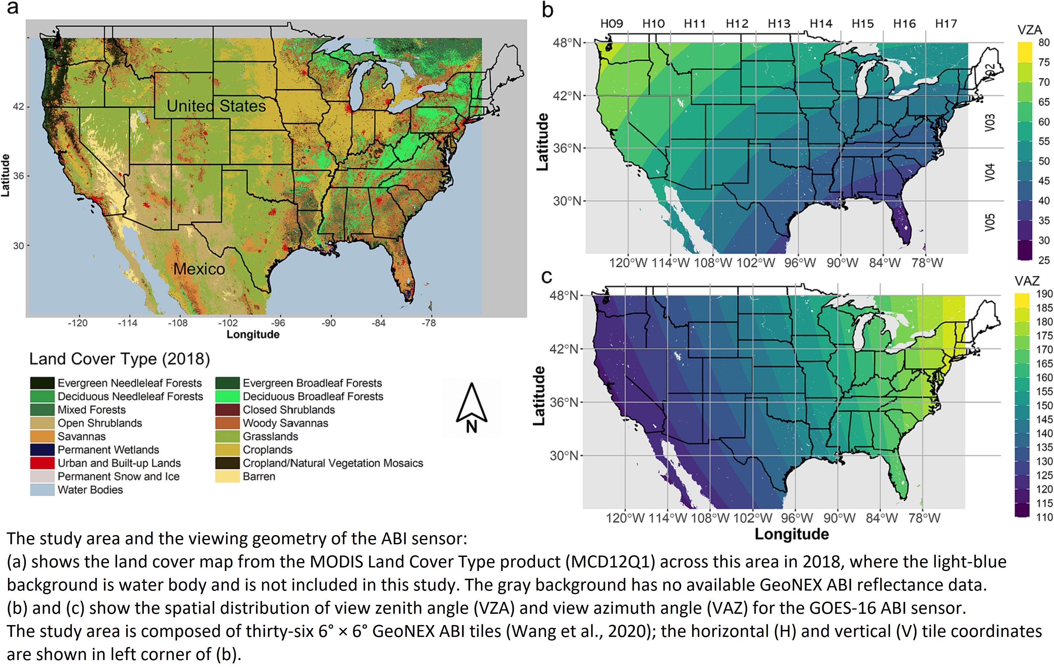
Analyzing GOES-R ABI BRDF-Adjusted EVI2 Time Series By Comparing With VIIRS Observations Over The CONUS
--
https://doi.org/10.1016/j.rse.2023.113972 <-- shared paper
--
#GIS #spatial #mapping #remotesensing #satellite #vegetation #GOESR #GOES #VIIRS #CONUS #diurnal #ABI #earthobservation #terrestrial #ecology #environment #environmentalscience #imagery #EVI2 #adjustments #postprocessing #RTLSR #model #BRDF #GeoNEX #GOES16 #agriculture #landcover #corrections #monitoring #greenness #NLCD

TIL:
The #Fire Information for Resource Management System (#FIRMS) distributes Near Real-Time (#NRT) active fire data from the Moderate Resolution Imaging Spectroradiometer (#MODIS) aboard the Aqua and Terra satellites, and the Visible Infrared Imaging Radiometer Suite (#VIIRS) aboard S-NPP and NOAA 20 (formally known as JPSS-1).
https://firms.modaps.eosdis.nasa.gov/map/#d:24hrs;@0.0,0.0,3.0z
This new paper about variability in #VIIRS DNB data is likely to be interesting to people who work on #RemoteSensing with #NighttimeLights: https://www.sciencedirect.com/science/article/pii/S1569843223003084
The latest VIIRS data from EOSDIS is showing the extent of the current fires here on Maui as of this morning. There are still active fires in Lahaina, upper and lower Kula, and Central Maui in the foothills.
#fires #remotesensing #NASA #VIIRS #maui #disasters #hawaii #hawaiimastodon #wx
Client Info
Server: https://mastodon.social
Version: 2025.04
Repository: https://github.com/cyevgeniy/lmst