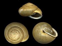
Vespericola armigera, #commonName the Santa Cruz hesperian, is a #species of air-breathing #landSnail, a #terrestrial #pulmonate #gastropod #mollusc in the family #Polygyridae.
#terrestrial
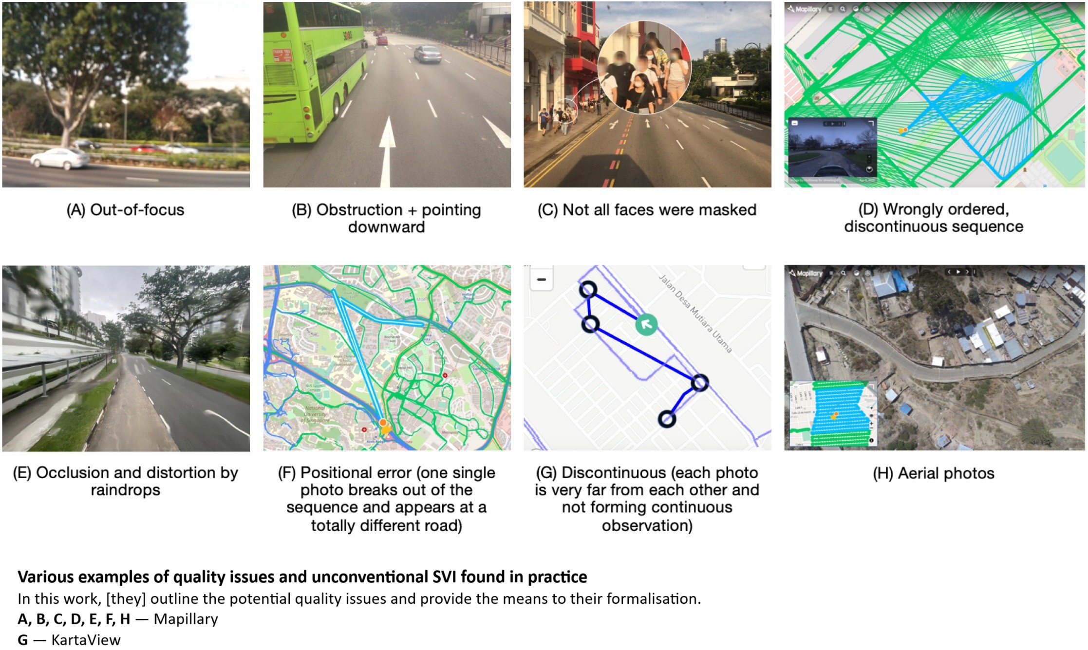
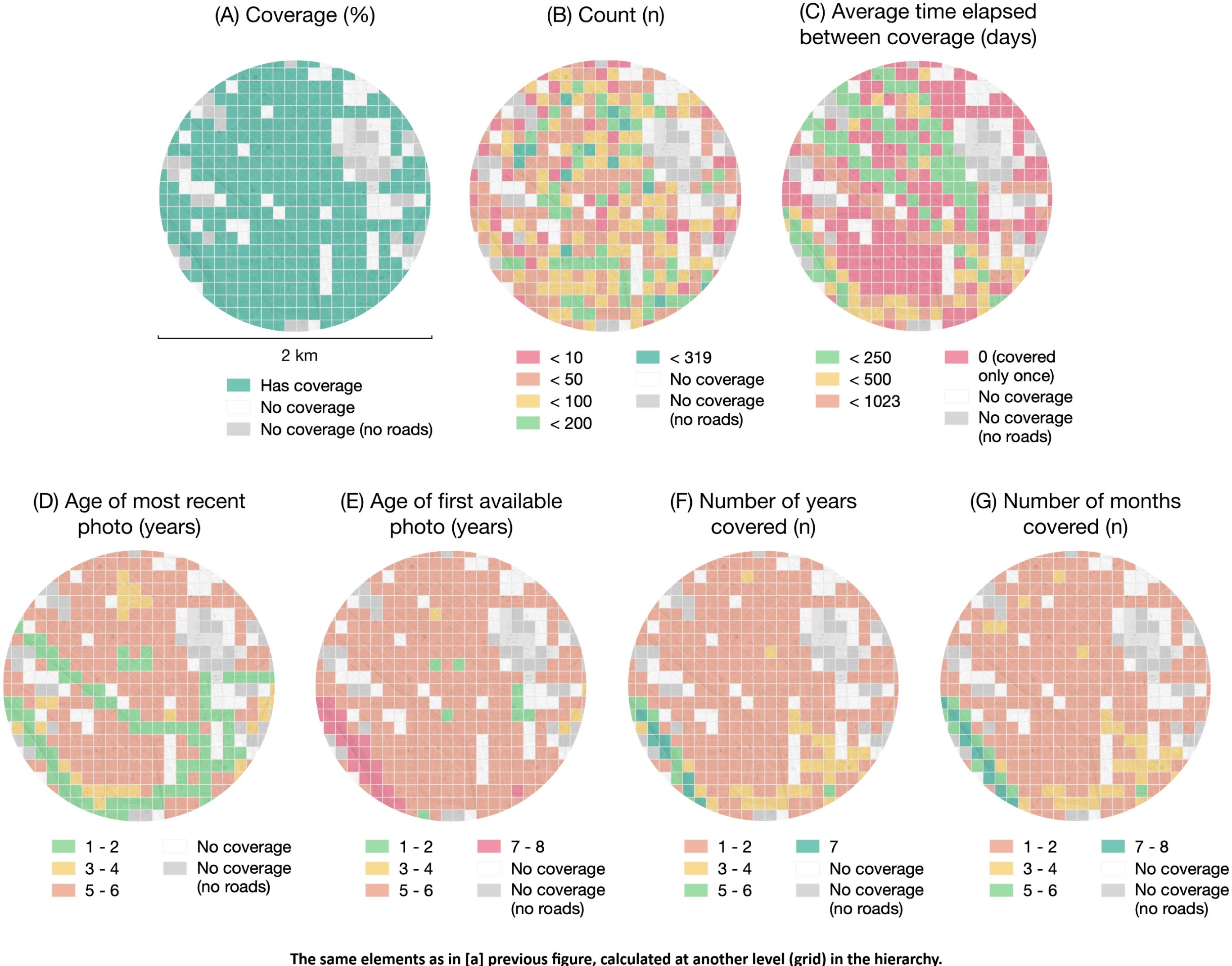
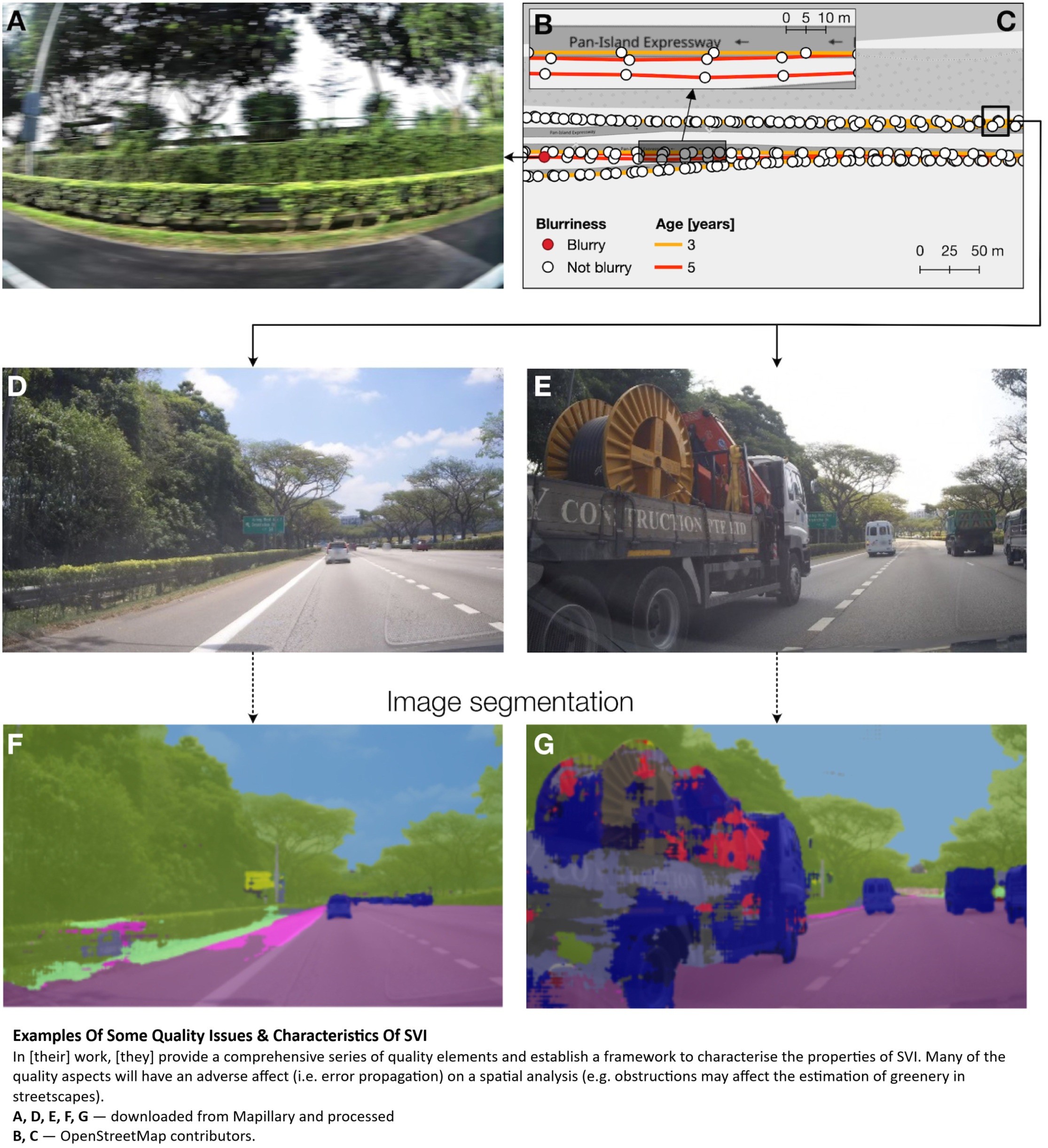
A Comprehensive Framework For Evaluating The Quality Of Street View Imagery
--
https://doi.org/10.1016/j.jag.2022.103094 <-- shared paper
--
“HIGHLIGHTS
• [They] propose the first comprehensive quality framework for street view imagery.
• Framework comprises 48 quality elements and may be applied to other image datasets.
• [They] implement partial evaluation for data in 9 cities, exposing varying quality.
• The implementation is released open-source and can be applied to other locations.
• [They] provide an overdue definition of street view imagery..."
#GIS #spatial #mapping #streetlevelimagery #Crowdsourcing #QualityAssessmentFramework #Heterogeneity #imagery #dataquality #metrics #QA #urban #cities #remotesensing #spatialanalysis #StreetView #Google #Mapillary #KartaView #commercial #crowsourced #opendata #consistency #standards #specifications #metadata #accuracy #precision #spatiotemporal #terrestrial #assessment

Giant, #Ancient Life Form Doesn’t Fit Into Any Known Branch of Life
Scientists have debated where #Prototaxites belong in tree of life for over a century, but now a new study suggests it might represent a whole new branch.
Researchers analyzed #fossil of Prototaxites species called Prototaxites taiti and concluded that it belonged to now-extinct lineage of multicellular #terrestrial #eukaryotes (organisms, including all animals and plants, whose cells contain a nucleus).
https://gizmodo.com/giant-ancient-life-form-doesnt-fit-into-any-known-branch-of-life-2000582118
Steve Pink’s ‘Terrestrial’ and Julie Pacino’s ‘I Live Here Now’ Among Fantasia 2025 First Wave Line-Up (EXCLUSIVE)
#Variety #News #Fantasia #FantasiaInternationalFilmFestival #ILiveHerenow #StevePink #Terrestrial
Even the worst #massextinction had its oases
Scientists have debated whether this event caused nearly as much terrestrial destruction. Now, researchers from the Nanjing Institute of Geology and Paleontology (NIGPAS) of the Chinese Academy of Sciences suggest that #terrestrial #ecosystems did not suffer nearly as much as the #oceans.
Plants thrived in present-day #China throughout the End-#Permian #extinction.
https://arstechnica.com/science/2025/03/even-the-worst-mass-extinction-had-its-oases/
https://www.alojapan.com/1257333/nec-achieves-japans-longest-terrestrial-wireless-optical-communication-over-10-km-press-releases/ NEC achieves Japan’s longest terrestrial wireless optical communication over 10 km: Press Releases #beam #FreeSpace #FSO #Japan #JapanNews #JapanTopics #nasushiobara #Network #news #OpticalFiber #QuantumCryptography #QuantumKey #RadioWaves #satellite #terrestrial #Tochigi #TokyoSkytree #WirelessCommunications FSO is a wireless communication method that enables high-speed and high-capacity communication compared to radio waves. It transm…
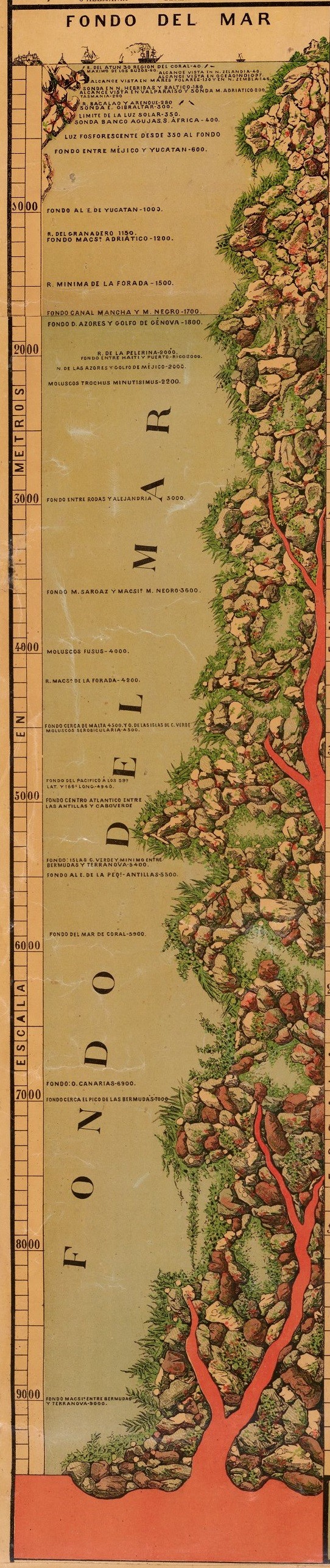
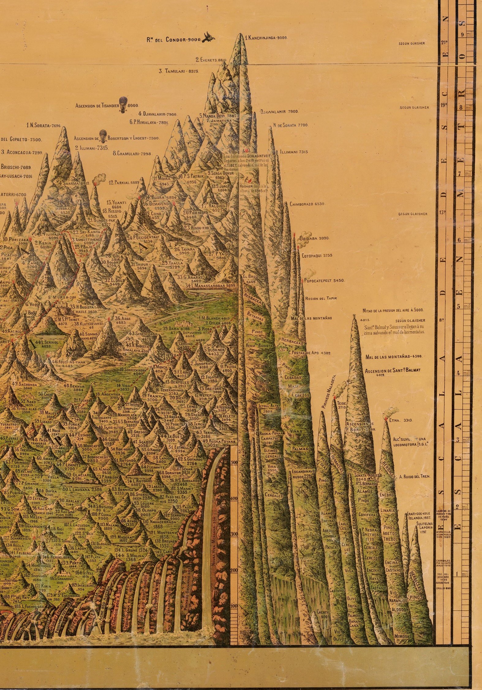
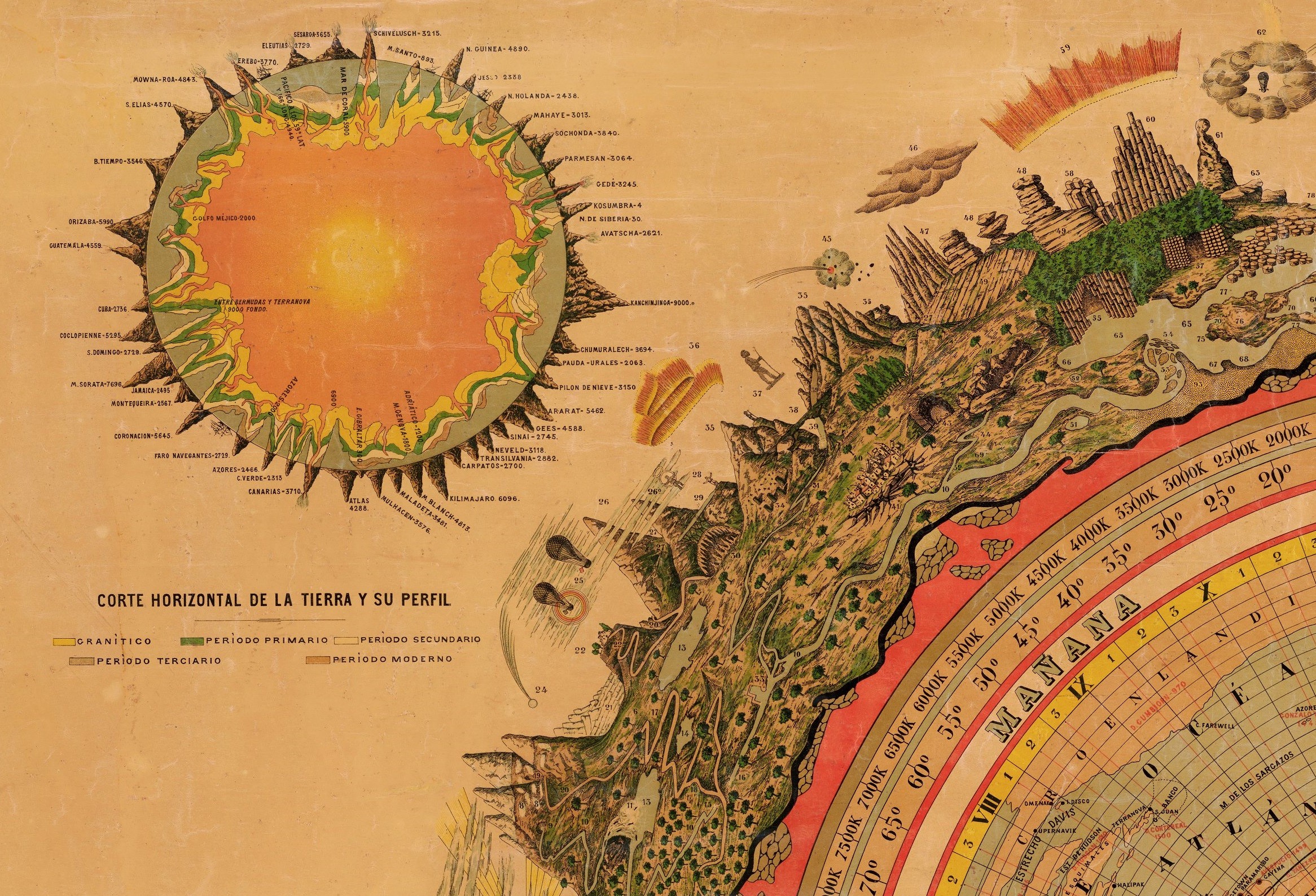
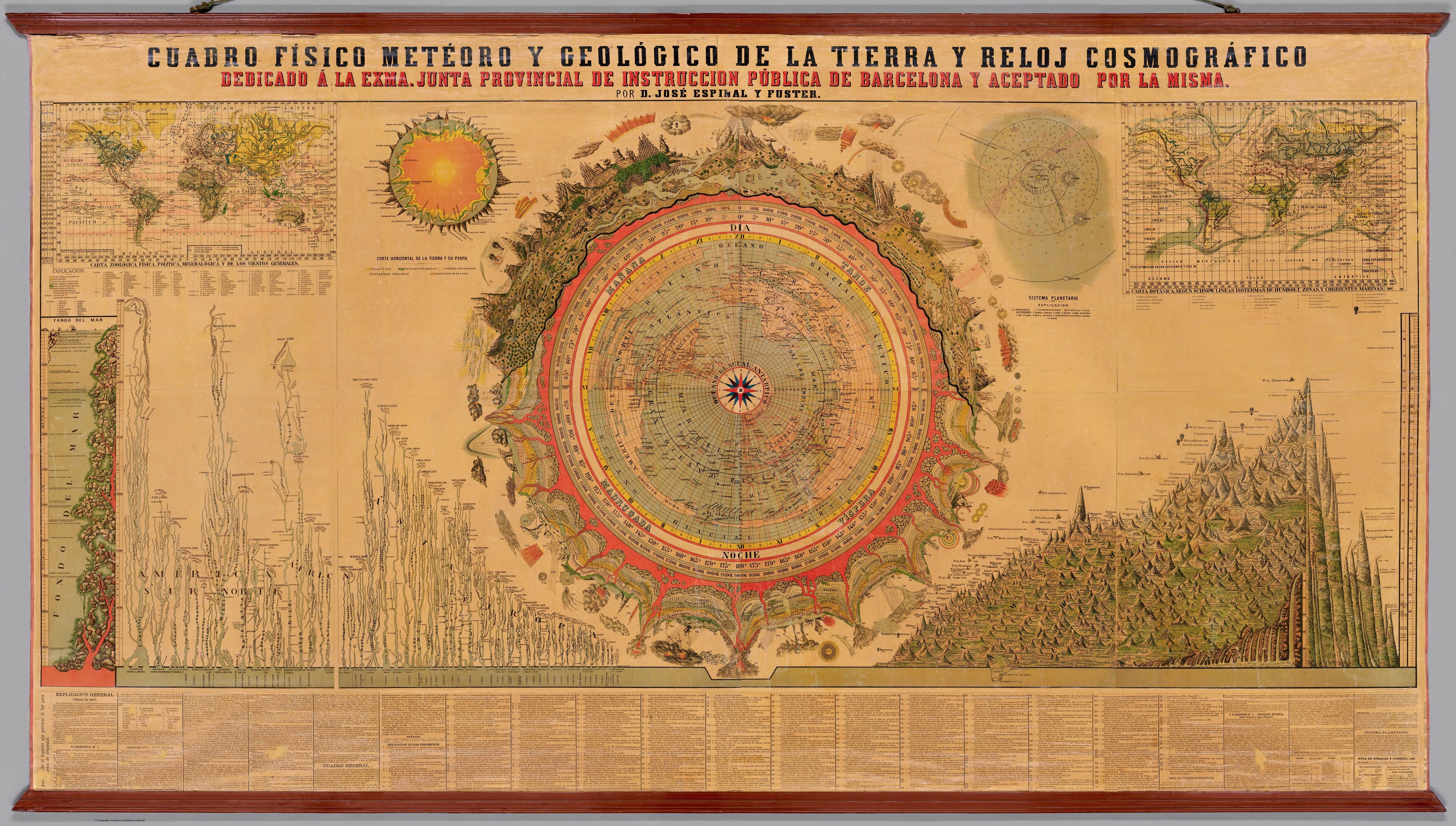
Cuadro Físico Meteoro y Geológico de la Tierra y Reloj Cosmográfico. (Physical, Meteorological, and Geological [1879] Chart of the Earth and Cosmographic Clock.)
--
https://www.davidrumsey.com/luna/servlet/detail/RUMSEY~8~1~366459~90133720:Cuadro-Fisico-Meteoro-y-Geologico <-- shared David Rumsey Map Collection holding, and download the high resolution digital copy of the map…
--
[the level of detail - with the ballon and other cartographic affectations…]
#GIS #spatial #mapping #cartography #maps #oldmaps #global #world #geography #geology #flora #fauna #terrestrial #FridayFeeling #gischat #Spain #rivers #mountains #humanity #globe #earth
@DavidRumseyMapCenter
#terrestrial : belonging to, or inhabiting, the land or ground, in distinction from trees, water, or the like
- French: terrestre
- Italian: terrestre
- Portuguese: terrestre
- Spanish: terrestre
------------
Word of The Hour's Annual Survey @ https://wordofthehour.org/r/form
The upcoming extremely large telescopes will provide the first opportunity to search for signs of #habitability and #life on non-transiting #terrestrial #exoplanets.
For the most accessible nearby target, #Proxima Centauri b, we may be able to rule out a sub-Neptune #atmosphere in as little as a single hour of observing, and some #biosignature disequilibrium pairs may be accessible in 10 hours.
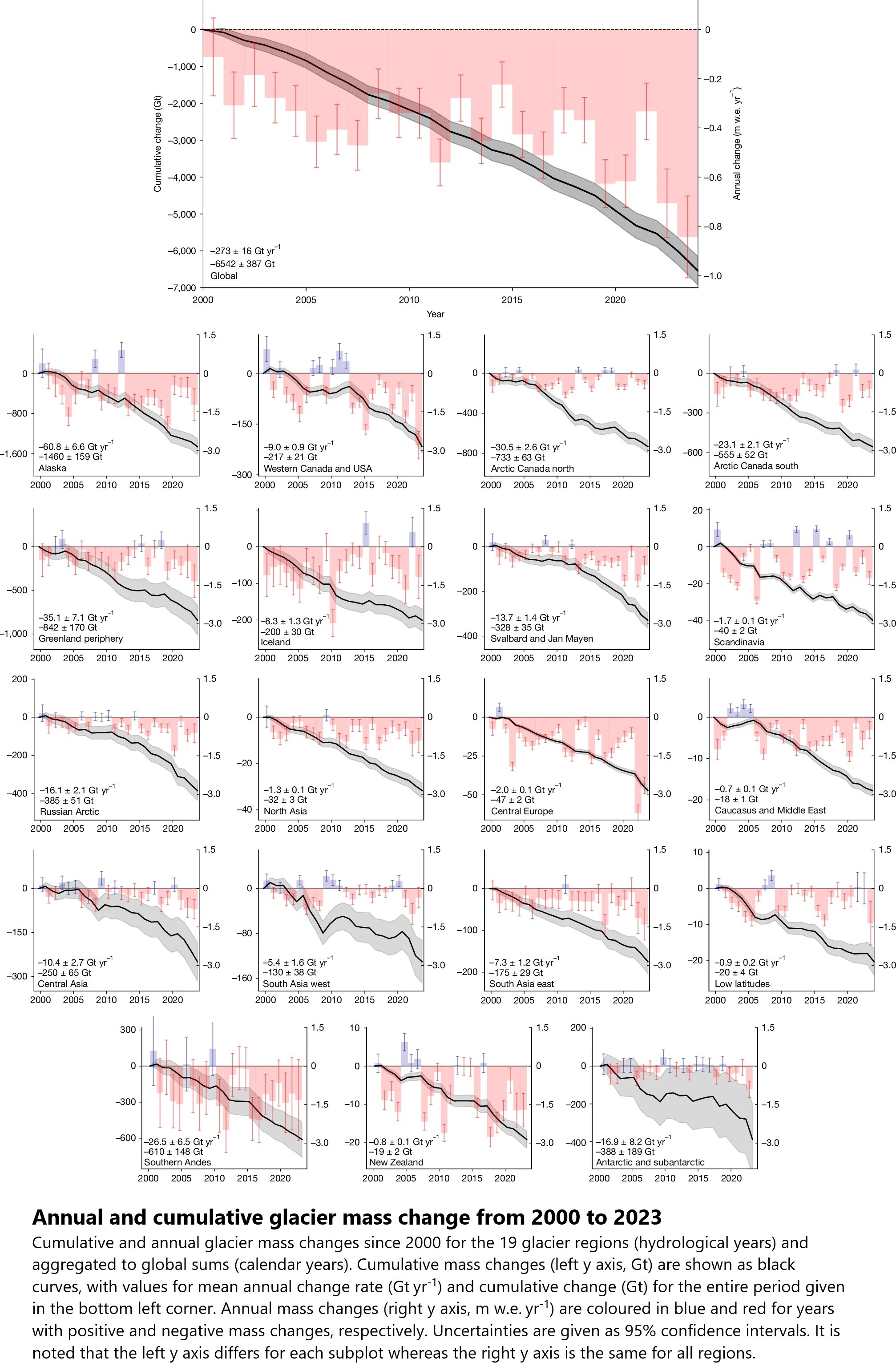
video overview - glacier ice loss over two decades
#GIS #spatial #mapping #GlacierMassBalanceIntercomparison #glacial #glacier #global #cryosphere #regional #frehwater #water #resources #waterresources #watersecurity #sealevel #sealevelrise #SLR #rate #change #spatialanalysis #spatiotemporal #ice #snow #loss #massloss #greenland #antarctic #icesheet #anthropogenic #climatechange #melt #melting #risk #hazard #geohazard #geology #engineeringgeology #marine #terrestrial #ecosystems #watercycle #masschange #insitu #remotesensing #local #observation #model #modeling #projection
Glacier Melt Intensifying Freshwater Loss And Accelerating Sea-Level Rise
--
https://www.esa.int/Applications/Observing_the_Earth/FutureEO/CryoSat/Glacier_melt_intensifying_freshwater_loss_and_accelerating_sea-level_rise <-- shared technical article
--
https://doi.org/10.1038/s41586-024-08545-z <-- shared paper
--
#GIS #spatial #mapping #GlacierMassBalanceIntercomparison #glacial #glacier #global #cryosphere #regional #freshwater #water #resources #waterresources #watersecurity #sealevel #sealevelrise #SLR #rate #change #spatialanalysis #spatiotemporal #ice #snow #loss #massloss #greenland #antarctic #icesheet #anthropogenic #climatechange #melt #melting #risk #hazard #geohazard #geology #engineeringgeology #marine #terrestrial #ecosystems #watercycle #masschange #insitu #remotesensing #local #observation #model #modeling #projection

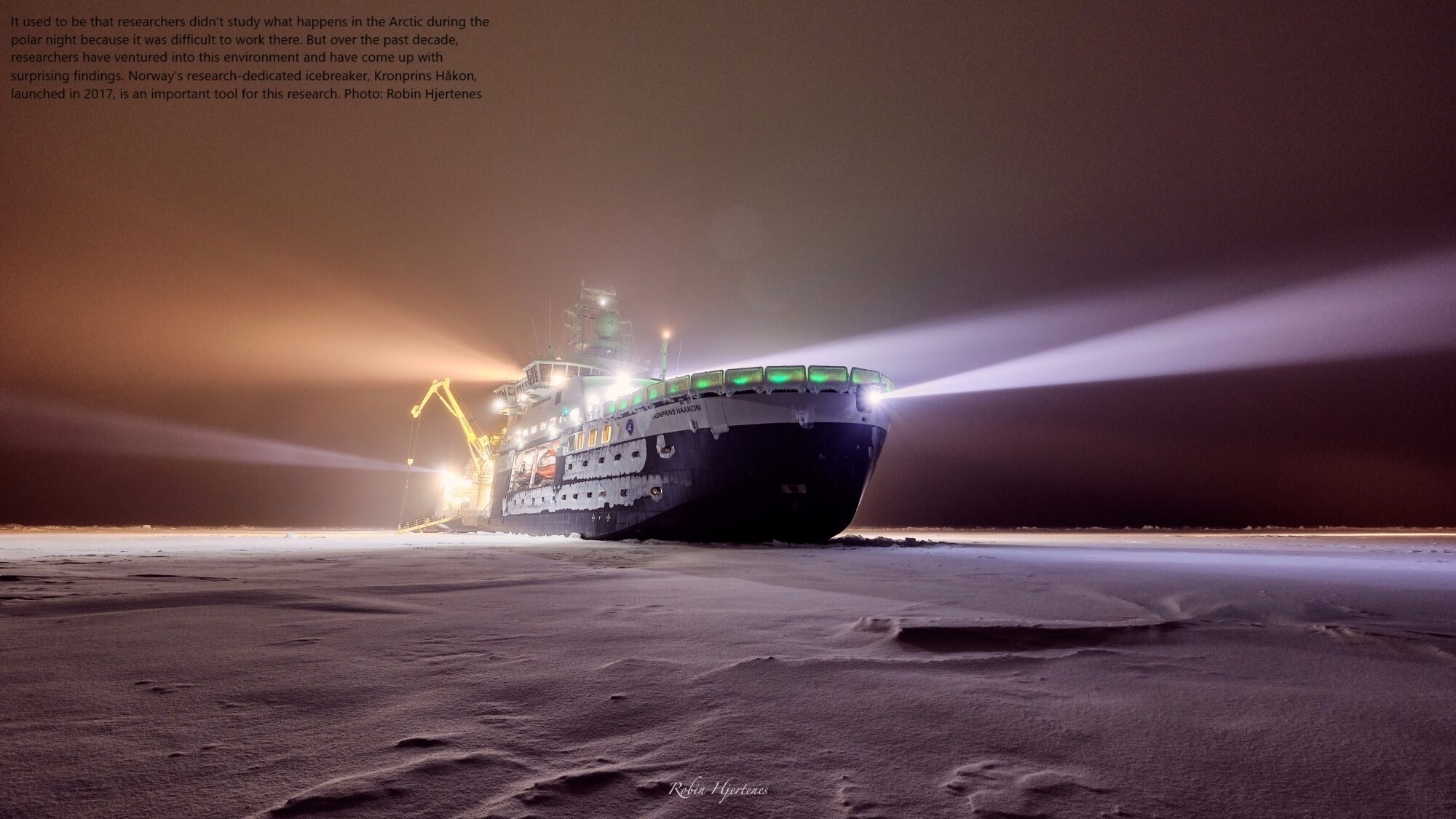
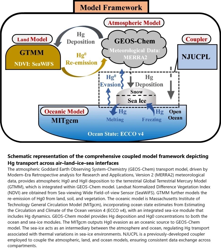
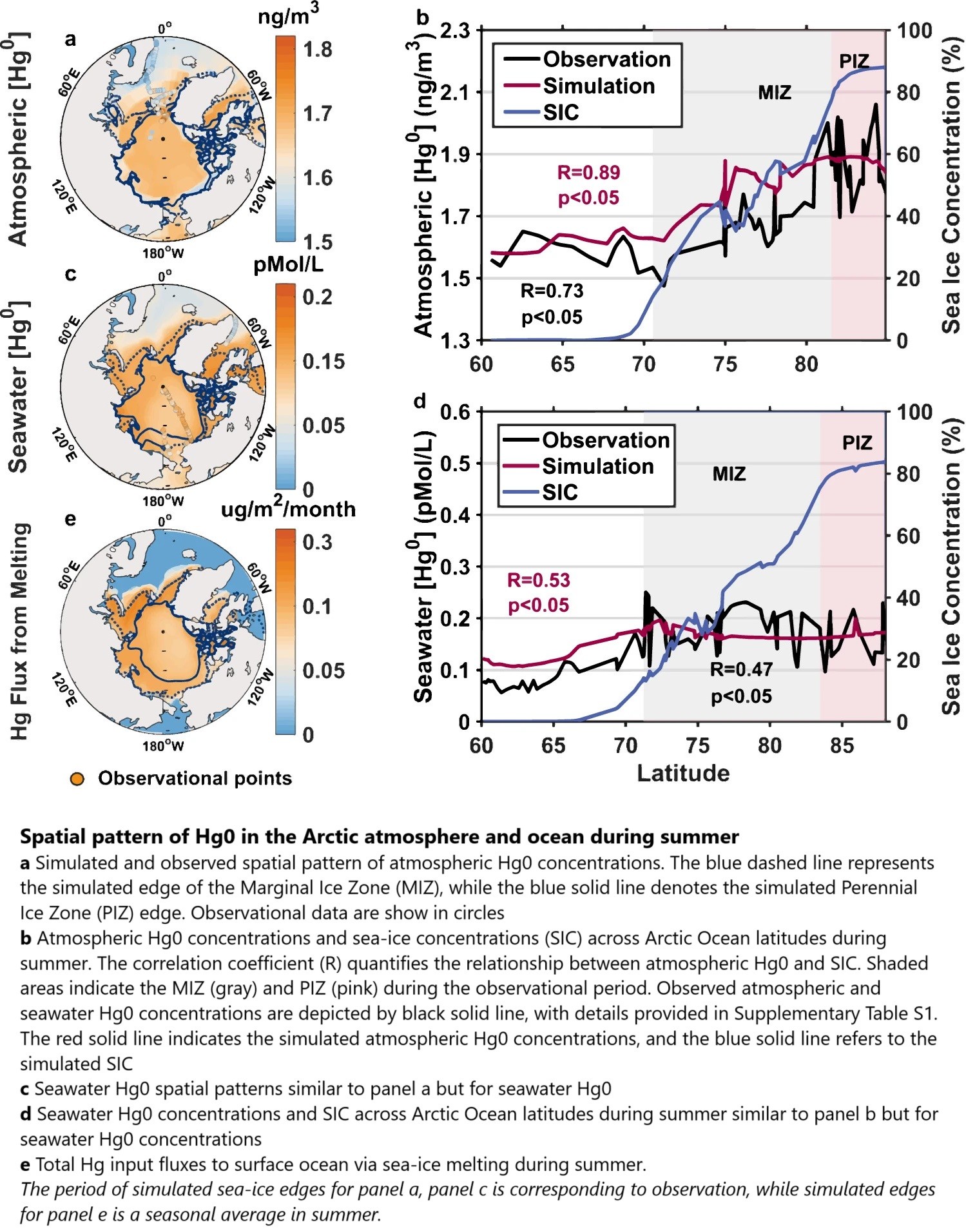
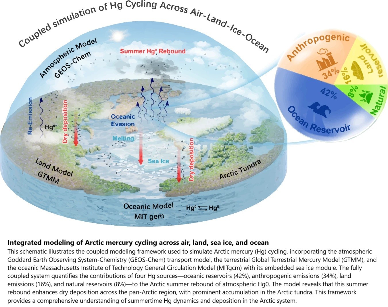
Oceanic Evasion Fuels Arctic Summertime Rebound Of Atmospheric Mercury And Drives Transport To Arctic Terrestrial Ecosystems
--
https://doi.org/10.1038/s41467-025-56300-3 <-- shared paper
--
#GIS #spatial #mapping #mercury #Hg #contamination #summerrebound #arctic #summertime #atmospheric #transport #contaminate #terrestrial #ecosystems #Hg0 #model #modeling #framework #spatialanalysis #spatiotemporal #concentrations #seaice #atmosphere #river #riverine #GDAS #GEOS #GEOSChem #MERRA2 #GTMM #global #NDVI #remotesensing #cycling #marine #ocean #water #hydrology #seawater #icemelt #anthropogenic #coast #coastal #tundra #permafrost #climatechange #evasion #vegetation #uptake #mitigation
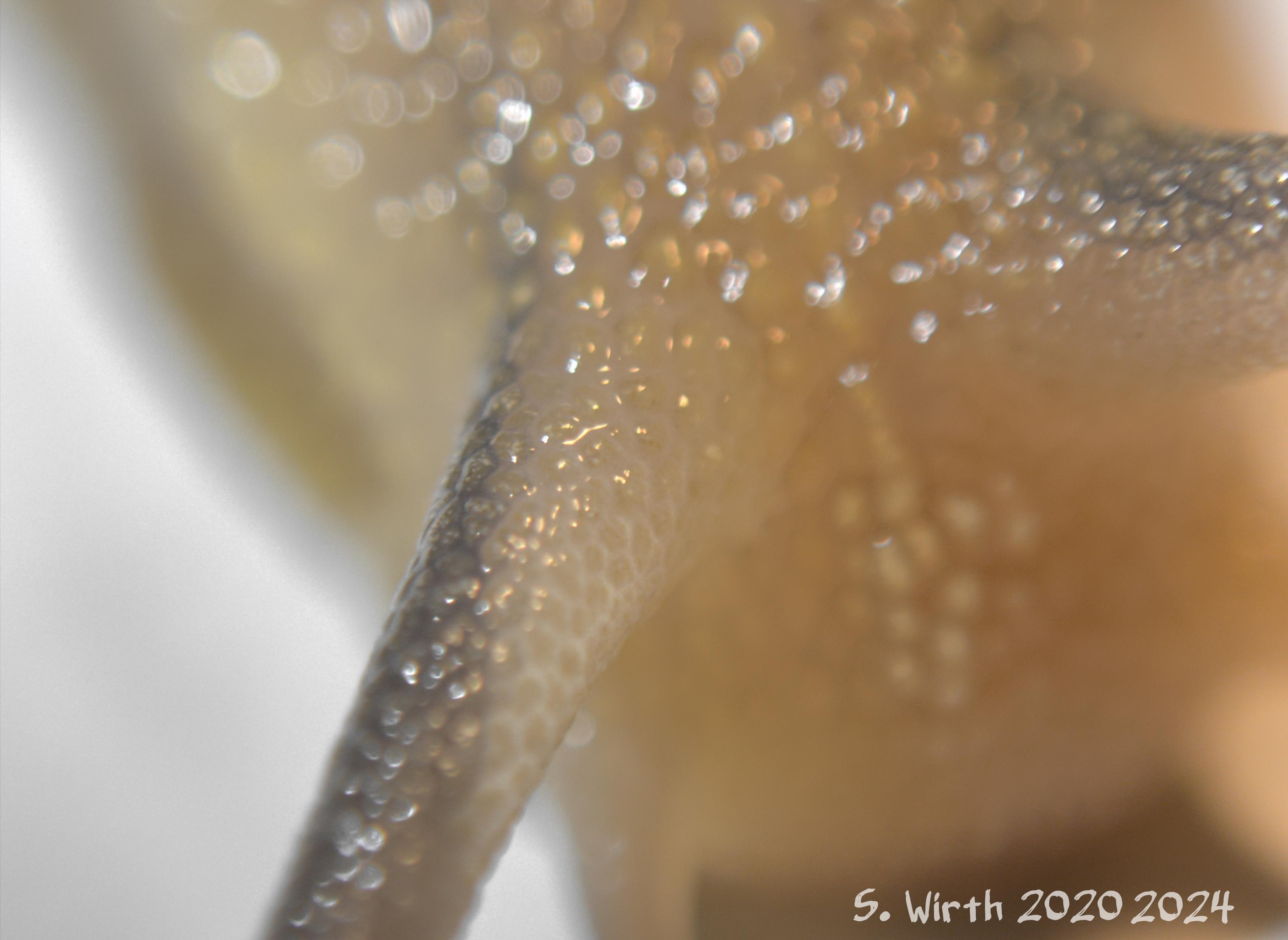
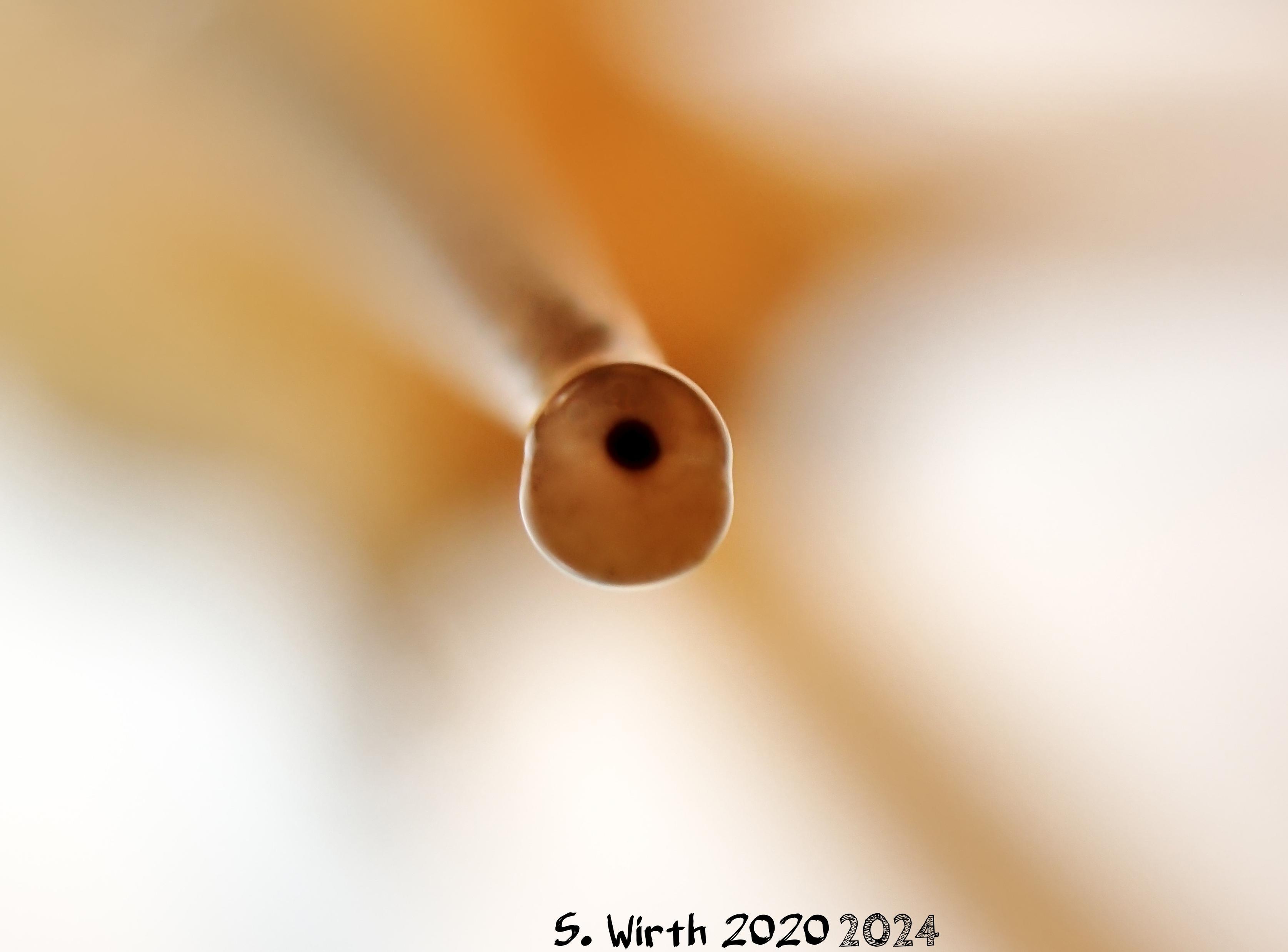
The #terrestrial #pulmonate #gastropods (#Stylommatophora, Gastropoda) have two pairs of #retractile #tentacles, an #apomorphy (#evolutionary innovation of the stem species) of the higher taxon Euthyneura. The rear pair of tentacles is elongated and has #eyes at its tips.
My photos show them in a close #macro shot using the Mediterranean #snail #species #Cornu #aspersum (#Helicidae).
#biodiversity #evolution
© #StefanFWirth Berlin 2024
Photos
C. aspersum, 2020, New edit 2024 © S. F. Wirth
Attention-Worthy Links for December 13th, 2024
#synchronous #memories #electroencephalogram #neocortex #long-term #Jezero #rim #anorthosite #superflares #magnetic #Ionizing #UV #X-rays #century #radiocarbon #Carrington #Peanuts #CBS #commercialism #Guaraldi #Linus #Luke #Geodesy #warped #terrestrial #water #storag
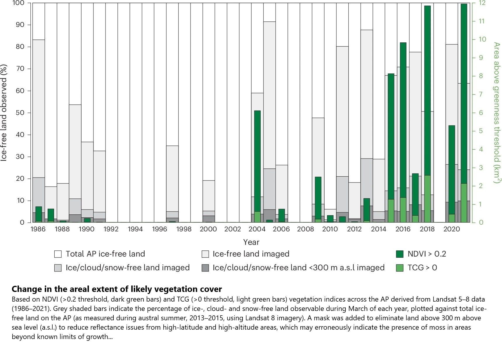
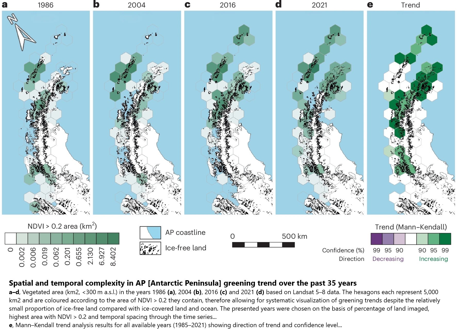
Striking Satellite Images Reveal Antarctica Is 10 Times Greener Than 35 Years Ago
--
https://www.sciencealert.com/striking-satellite-images-reveal-antarctica-is-10-times-greener-than-35-years-ago <-- shared technical article
--
https://doi.org/10.1038/s41561-024-01564-5 <-- shared paper
--
#GIS #spatial #mapping #remotesensing #landsat #change #Antarctic #AntarcticPeninsula #spatialanalysis #spatiotemporal #climatechange #greening #vegetation #change #warming #satellite #browning #cryosphere #anthropogenic #warming #moss #terrestrial #ecosystems #GoogleEarthEngine #NDVI #TCG #icefree #model #modeling
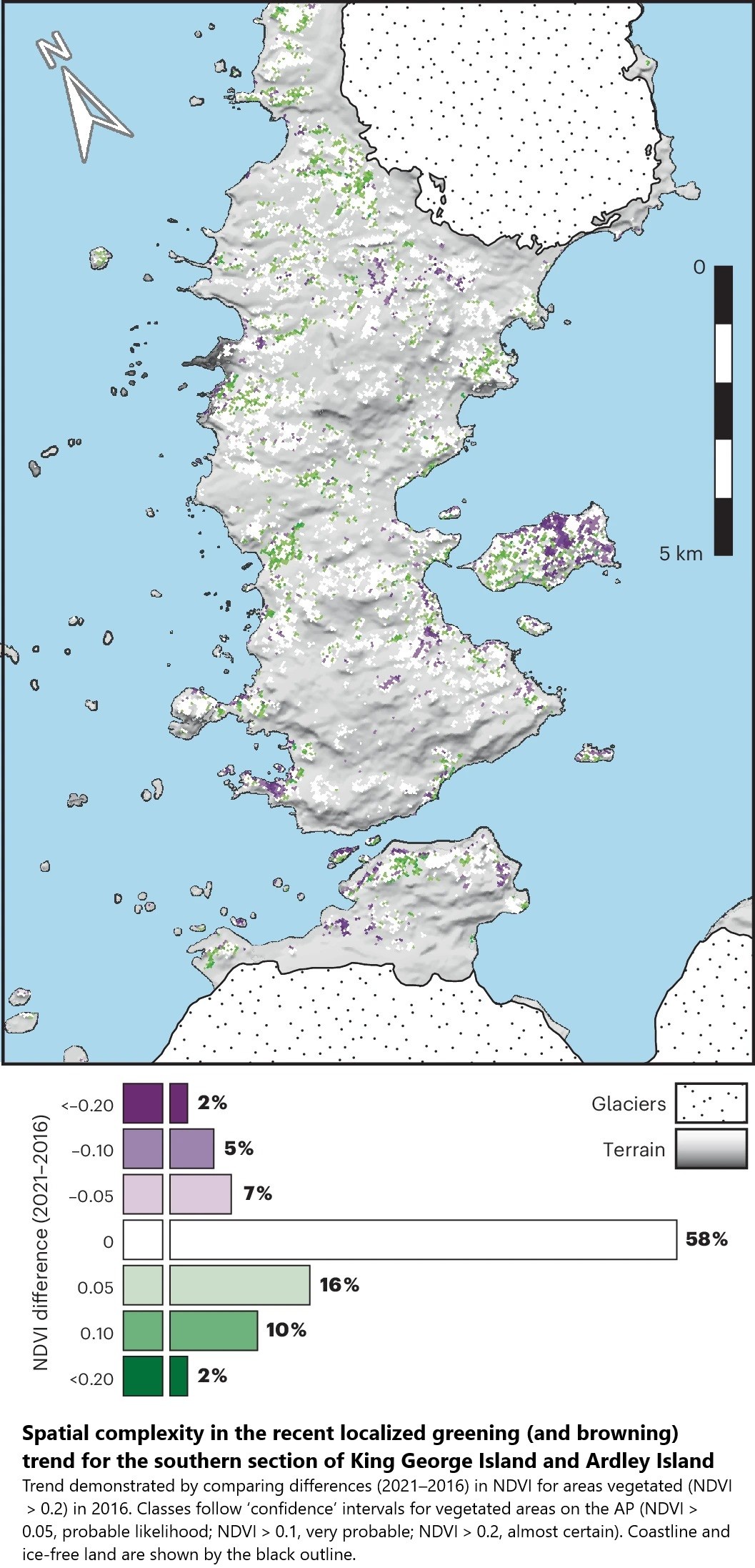
![photos - Moss-dominated ecosystems across the AP [Antarctic Peninsula]](https://files.mastodon.social/cache/media_attachments/files/113/632/144/276/548/722/original/a83884f3f568b270.jpg)
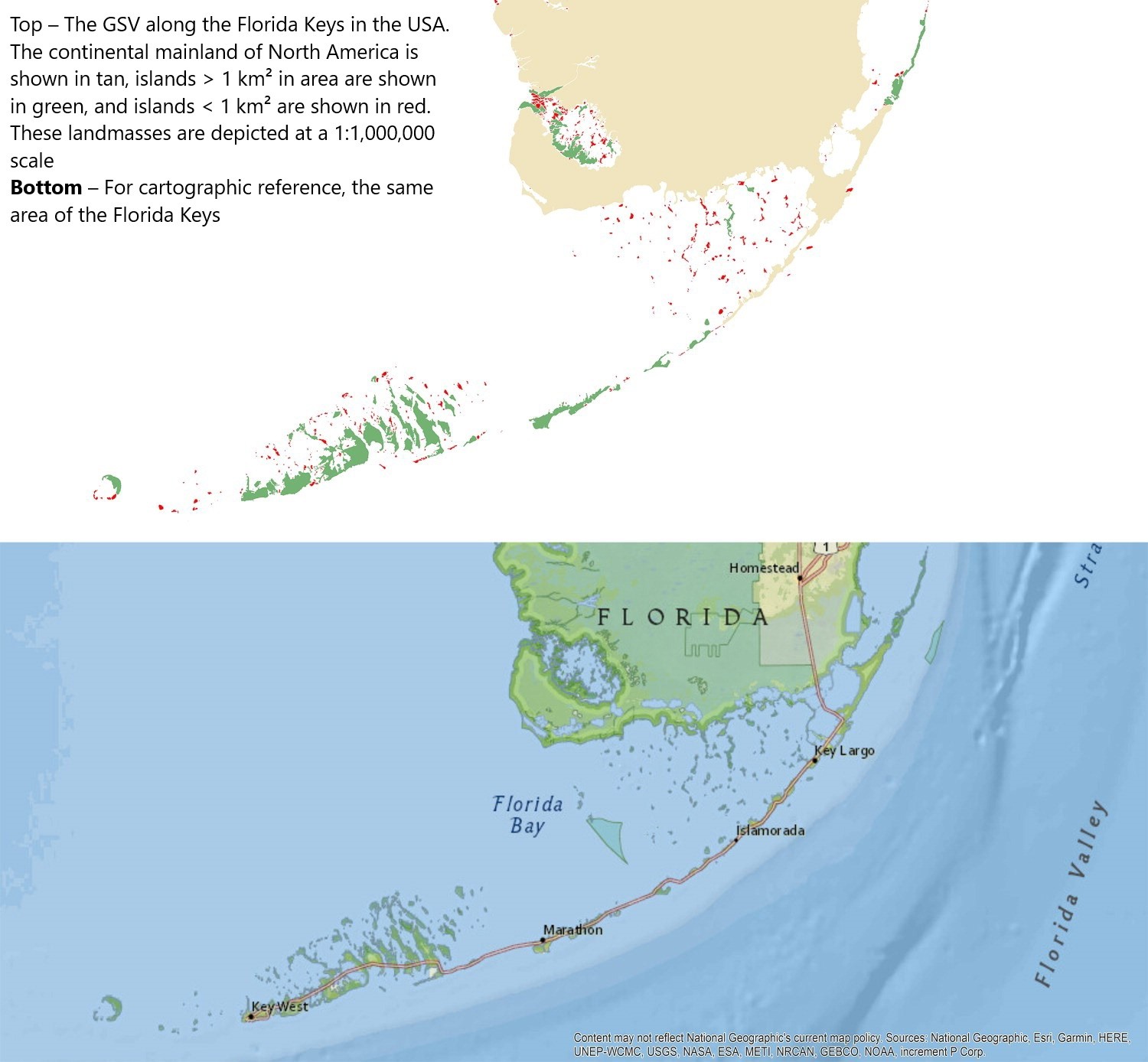
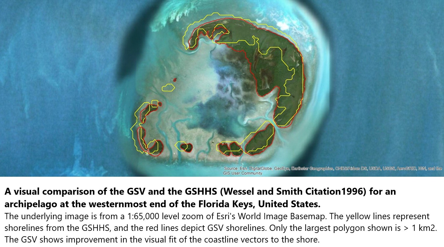
New [2018] 30 Metre Resolution Global Shoreline Vector And Associated Global Islands Database For The Development Of Standardized Ecological Coastal Units
--
https://doi.org/10.1080/1755876X.2018.1529714 <-- shared 2018 paper
--
#GIS #spatial #mapping #coast #coastline #global #shoreline #landsat #remotesensing #spatialanalysis #extraction #AI #machinelearning #GSV #GSHSS #ecology #terrestrial #marine #ECU #waters #GEO #GoogleEarthEngine #MBON #BluePlanet #water #hydrography #hydrospatial #GroupOnEarthObservations
@GroupOnEarthObservations #islands @GEOSEC2025
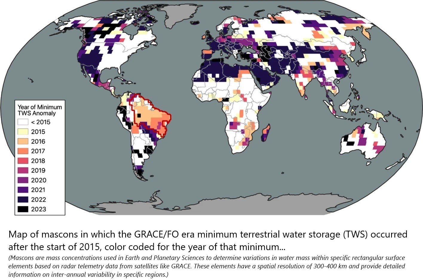
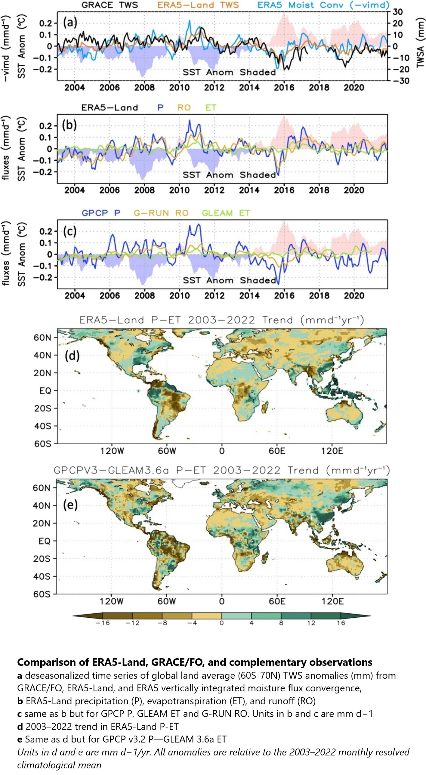
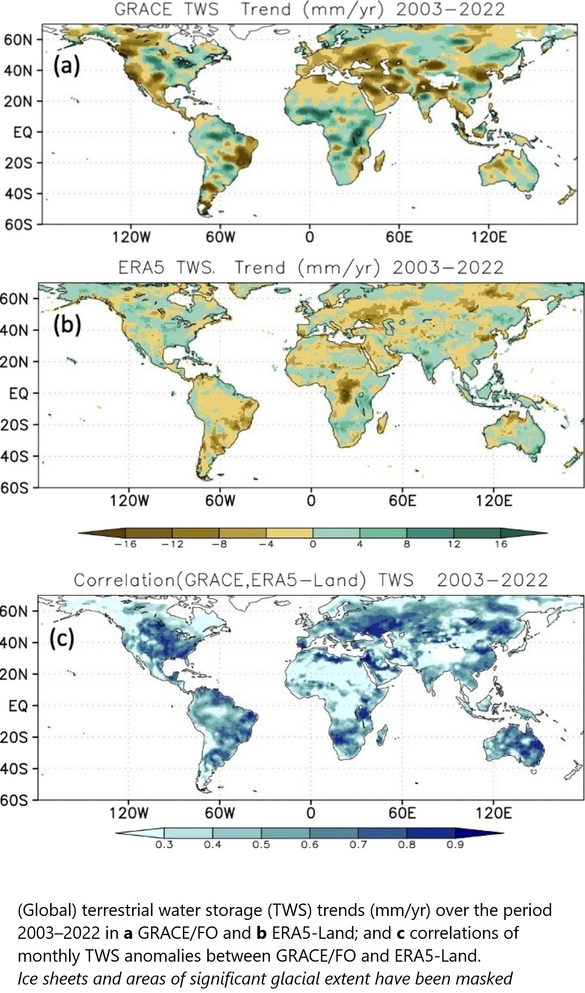
NASA Satellites Reveal Abrupt Drop In Global Freshwater Levels | An Abrupt Decline in Global Terrestrial Water Storage and Its Relationship with Sea Level Change
--
https://phys.org/news/2024-11-nasa-satellites-reveal-abrupt-global.html <-- shared technical article
--
https://doi.org/10.1007/s10712-024-09860-w <-- shared paper
--
https://www.unesco.org/reports/wwdr/en/2024 <-- shared UN report on water stress
--
#GIS #spatial #mapping #remotesensing #satellite #NASA #GRACE #ERA5 #water #waterresources #climatechange #sealevel #sealevelrise #SLR #waterresources #global #freshwater #watermanagement #arid #terrestrial #mascons #TWS #terrestialwaterstorage #surfacewater #groundwater #aquifers #spatialanalysis #model #modeling #spatiotemporal #drought #wateruse #watersecurity #agriculture #irrigation #hydrology #publichealth #risk #hazard #naturalresources #waterquality #gravity
Marine ecozones represent a major gap in Canadian DNA barcoding efforts
Comparison of the DNA barcode coverage from Canadian terrestrial and marine ecozones.
https://www.facetsjournal.com/doi/full/10.1139/facets-2024-0015
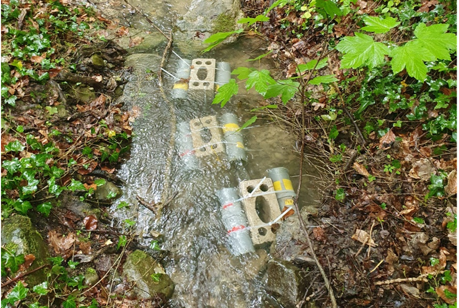
Leaf litter processing is crucial for integrating #terrestrial material into #aquatic food webs. Our study published in #oikos_journal reveals how the population #density of native and non-native #amphipods affects #leaf litter processing.
2024 LIVING PLANET REPORT
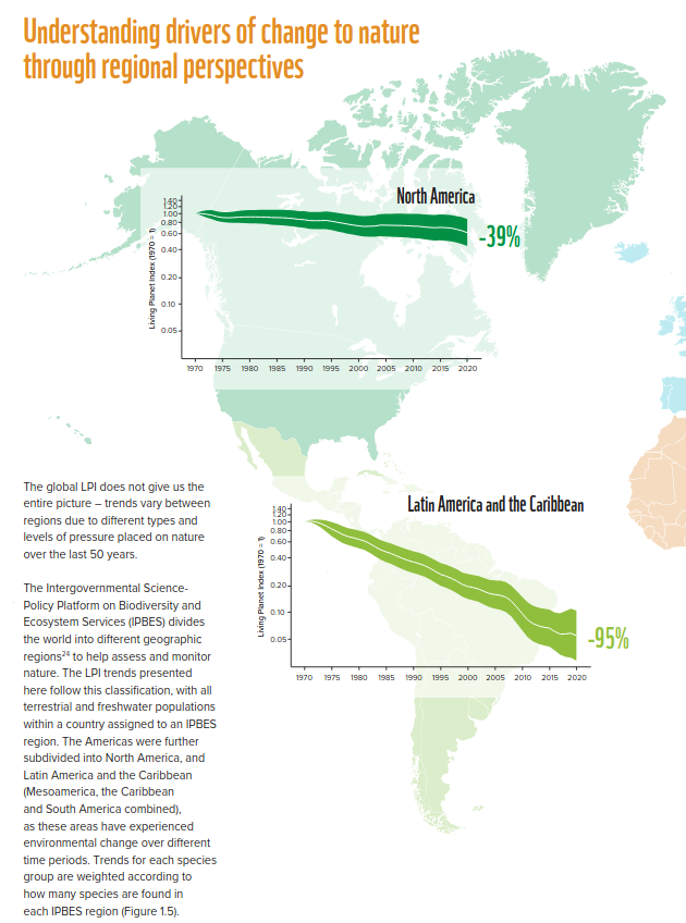
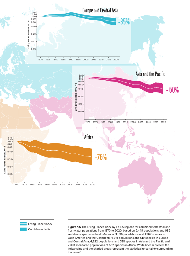
Over the past 50 years (1970–2020), the average size of monitored #wildlife populations has shrunk by 73%.
Based on almost 35,000 population trends and 5,495 species of #amphibians, #birds, #fish, #mammals and #reptiles. Freshwater populations have suffered the heaviest declines, falling by 85%, followed by #terrestrial (69%) and #marine populations (56%).
Report (PDF):
https://www.wwf.at/wp-content/uploads/2024/10/WWF-at_LivingPlanetReport-2024.pdf
Client Info
Server: https://mastodon.social
Version: 2025.04
Repository: https://github.com/cyevgeniy/lmst