#historicmaps

2025-11-19

RE: mapstodon.space/@jcarlson/1155

Coming up in a little over *one hour*!

Interested in #HistoricMaps and #Sanborn Fire Insurance maps? Want to spend an hour of GIS day listening to a passionate student talk about an awesome project?

Join us!

v.ringcentral.com/join/3092427

#gischat

💧🌏 Greg CocksGregCocks@techhub.social
2024-04-08

Mappa Mundi - The Greatest Map Of The Medieval World [video]
--
youtube.com/watch?v=LB5B6wY8k5 <-- shared media video (BBC)
--
en.wikipedia.org/wiki/Mappa_mu <-- Wikipedia page
--
“On the second floor of the Library of Saint Marks in Venice, Italy, a map of the world occupies an entire room.
The Mappa Mundi, completed by Italian monk and cartographer Fra Mauro in 1459 AD, is the compendium of all the geographical knowledge of the time and is arguably the greatest medieval map of the world…”
#GIS #spatial #mapping #cartography #history #medieval #MedievalMonday #maps #cartography #Venice #Venezia #Italia #Italy #mappamundi #ancientmaps #historicmaps #gischat #global #worldmap

2024-04-08

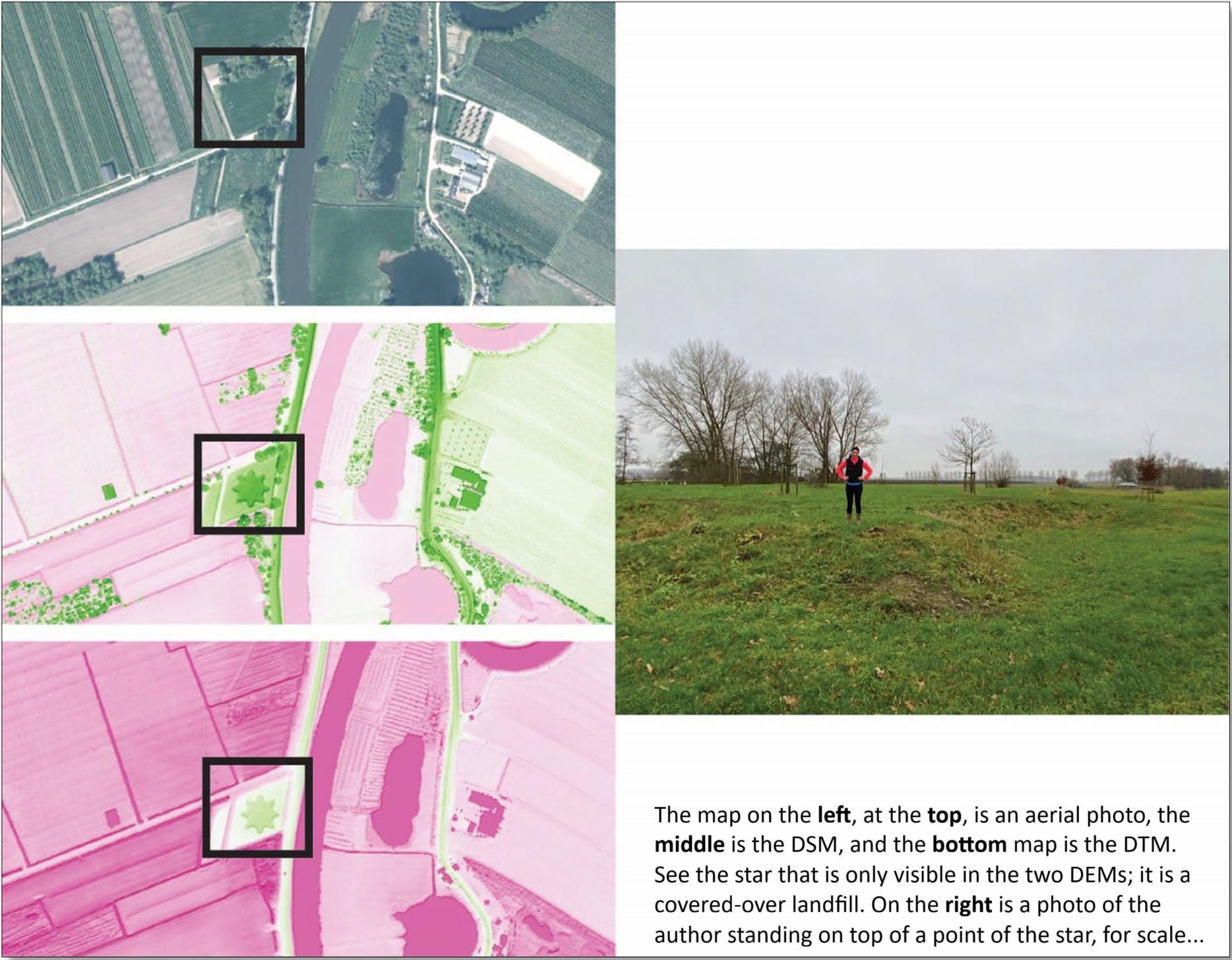
Very excited to now have my birthday present framed!

This is a copy of an 1885 lithograph of Auckland, NZ, drawn as if from a point 1000ft above and 100ft to the rear of the hospital, by George Treacy Stevens.

I realise the photograph has nothing for scale, but the map is huge (the frame is 98x78cm)! This will hang above my desk, which may be dangerous to my productivity as there are so many fascinating details :)

I first saw this years ago on a bag or poster or somewhere, and traced it back to a copy in Auckland Libraries' Kura | Heritage Collections Online (Map 4641, kura.aucklandlibraries.govt.nz ), though when printing out this copy I used the scan from the National Library, as it was higher resolution (D-001-006, ndhadeliver.natlib.govt.nz/del )

According to their catalogue this is the only detailed birds eye view of a 19th century New Zealand city!

#Auckland #Maps #HistoricMaps #mapstodon #MapsMonday

A coloured historic map in a pale wooden frame rests against a wall.
2024-02-29

In 1899, the New York State Department of Agriculture produced a "map showing the location of the butter and cheese factories in the State of New York." This is the legend from that map:

#maps #history #localhistory #ephemera #historicmaps #NewYorkState #NewYorkHistory #UpstateNewYork

Legend from an 1899 map. Open circle indicates a butter factory. Closed (green?) circle indicates a cheese factory. Plus sign indicates a butter and cheese factory.
2024-02-14

La représentation cartographique de l'Europe en reine du monde est un grand classique du début de l'époque moderne, mais j'ai toujours été troublée par les choix graphiques associés...
#carto #maps #HistoricMaps #Earlymodern
en.wikipedia.org/wiki/Europa_r

Irish Studies at QUBIrishStudiesQUB@zirk.us
2023-10-10

From National Library of Scotland: Our County/Parish search in our MapFinder and Georeferenced viewers now includes Irish counties and parishes. maps.nls.uk/geo/find/
maps.nls.uk/geo/explore/
#HistoricMaps #Ireland #OrdnanceSurvey #IrishHistory

2023-09-30

#Oxford residents & alumni, what are your favourite #14thCentury aspects of your #HistoricCity? Any quirks to highlight after seeing the #HistoricTownsTrust #map, or the new overlay from #MedievalMurderMaps? Ghostly, evocative, thoughts on green space & a #15MinuteCity?
medievalmurdermap.co.uk/maps/o

#medieval #maps #HistoricMaps @trishgreenhalgh @HLaehnemann @OxMedStud @dancingtreefrog @medievodons @histodons

Part of the centre of Oxford, from the High Street to modern Broad Street, showing 14th century murder spots & the weapons of choice - detail from the Medieval Murder Map linked above.
2023-09-29

Thanks @dancingtreefrog - the new website #MedievalMurderMaps is a delight! Interactive descriptions of each incident from the #CoronersRolls, plus clear & informative posts on #medieval life.
🙏 to the authors for wonderful imagery, & careful inclusion of source refs.
medievalmurdermap.co.uk/blog/

#14thCentury #murder #maps #HistoricMaps #OxfordUniversity #Oxford #London #York #coroner #medievodons @medievodons @histodons

Screenshot from the blog index, 6 posts with relevant contemporary images. They're entitled 1. Alehouses, Taverns & Inns; 2. Games, Music & Sports; 3. Medieval Marketplaces; 4. Knives, Swords & Stones; 5. Accidental Deaths; 6. Rightful Death.
2023-09-16

@BenjaminHCCarr Thanks for highlighting this analysis suggesting widespread #medieval consumption of gray & right #whales - & the interesting #map, the #CartaMarina of 1539, with its splendid illustrations of a wide range of #SeaMonsters & their diverse tactics for dealing with aggressive seafarers.
en.wikipedia.org/wiki/Carta_ma
#HistoricMaps #MedievalShip #16thCentury #whaling #medievodons @medievodons @histodons

A detail of the Carta Marina, showing Iceland, Norway, the Faroe & Orkney Islands, with sea serpents & dragons & walrus-like creatures grappling with smaller ships attempting to harpoon & kill them. One ship is disappearing into a whirlpool; a giant lobster holds a man in one claw. The Wikipedia page links to a full image with higher resolution, & explains how the map's existence was rediscovered.
💧🌏 Greg CocksGregCocks@techhub.social
2023-08-16

The Kingdom of Bhutan [1965 cartography]
--
collections.lib.uwm.edu/digita <-- link to map and details
--
doi.org/10.1111/j.1467-8306.19 <-- shared paper’s note, 2010
--
[“a yam between two boulders.” (China (Tibet) and India)]
“Contained in (work): Association of American Geographers Annals of the Association of American Geographers…
Relief shown by shading and spot heights…”
#GIS #spatial #mapping #bhutan #kingdomofbhutan #map #cartographer #cartography #topography #relief #transportation #seasia #hydrology #historic #historicmaps #landform #geomorphology #terrain #gischat #AAG
@americangeo

Hidden GemsHiddenGems
2023-06-18

Immerse in the breathtaking silk map of Jing & Wei Rivers at 🌊 Witness Imperial China's mastery in waterway management with Dong Gao's vivid report in calligraphy! How might these geographic wonders shape present-day ?🤔

clevelandart.org/art/1915.618.a

Jonathan WrightJon6705@mastodon.world
2023-06-13
💧🌏 Greg CocksGregCocks@techhub.social
2023-05-18

Ancient Courses - Harold Fisk’s Meander Maps Of The Mississippi River (1944)
--
kottke.org/19/06/the-marvelous <-- shared blog post
--
[Daniel Coe has done and continues to make amazing hydrographic cartography in this regard, see image attached]
--
“[T]housands of years of course changes compressed into a single image by a clever mapmaker with an artistic eye. Looking at them, you're invited to imagine the Mississippi as it was during the European exploration of the Americas in the 1500s, during the Cahokia civilization in the 1200s (when this city's population matched London's), when the first humans came upon the river more than 12,000 years ago, and even back to before humans, when mammoths, camels, dire wolves, and giant beavers roamed the land and gazed upon the river…”
#GIS #spatial #mapping #hydrology #mississippi #cartography #hydrology #water #river #meanders #representation #map #maps #historicmaps #banks #art #artwork #gischat #HaroldFisk
#USACE #fluvial
@kottke

💧🌏 Greg CocksGregCocks@techhub.social
2023-05-03

If The Ancient Romans Had Google Maps - Omnesviae Is A Modern Route Planner Based On The Roads Of The Roman Empire
--
bigthink.com/strange-maps/omne <-- shared article
--
omnesviae.org/ <-- OmnesViae - Roman RoutePlanner
--
[combining professional and personal interests]
#GIS #spatial #mapping #gischat #network #webmap #romanempire #ancientrome #ancienthistory #transportation #infrastructure #roads #commerce #military #OmnesViae #routing #publicroads #TabulaPeutingeriana #history #ancientmaps #historicmaps #itinerarium #peutingermap #onlinemapping #onlinemap

💧🌏 Greg CocksGregCocks@techhub.social
2023-04-18

Terra Nostra, 1550-1950 - The Stories Behind Canada's Maps [lunchtime reading for a #mapnerd]
--
mqup.ca/terra-nostra--1550-195 <-- link to book details
--
[a wonderful description of maps in their exploration, historic, cultural, economic and political settings]
“Maps have been invaluable throughout Canada's history. They promised fame and fortune to early merchant-adventurers and guided army commanders. They legitimized a politician's dominion and allowed businessmen to stake new claims. And they helped ordinary citizens build communities. Terra Nostra celebrates the mapping of Canada, in part by telling the stories of the exceptional individuals who helped to create the maps..."
#GIS #spatial #mapping #Canada #history #maps #cartography #gischat #context #historic #nationbuilding #historicmaps #economics #politics #exploration #culture #cultural #appliedscience #cartographie #geography #maplesyrup #Chesterfield

Client Info

Server: https://mastodon.social
Version: 2025.07
Repository: https://github.com/cyevgeniy/lmst