
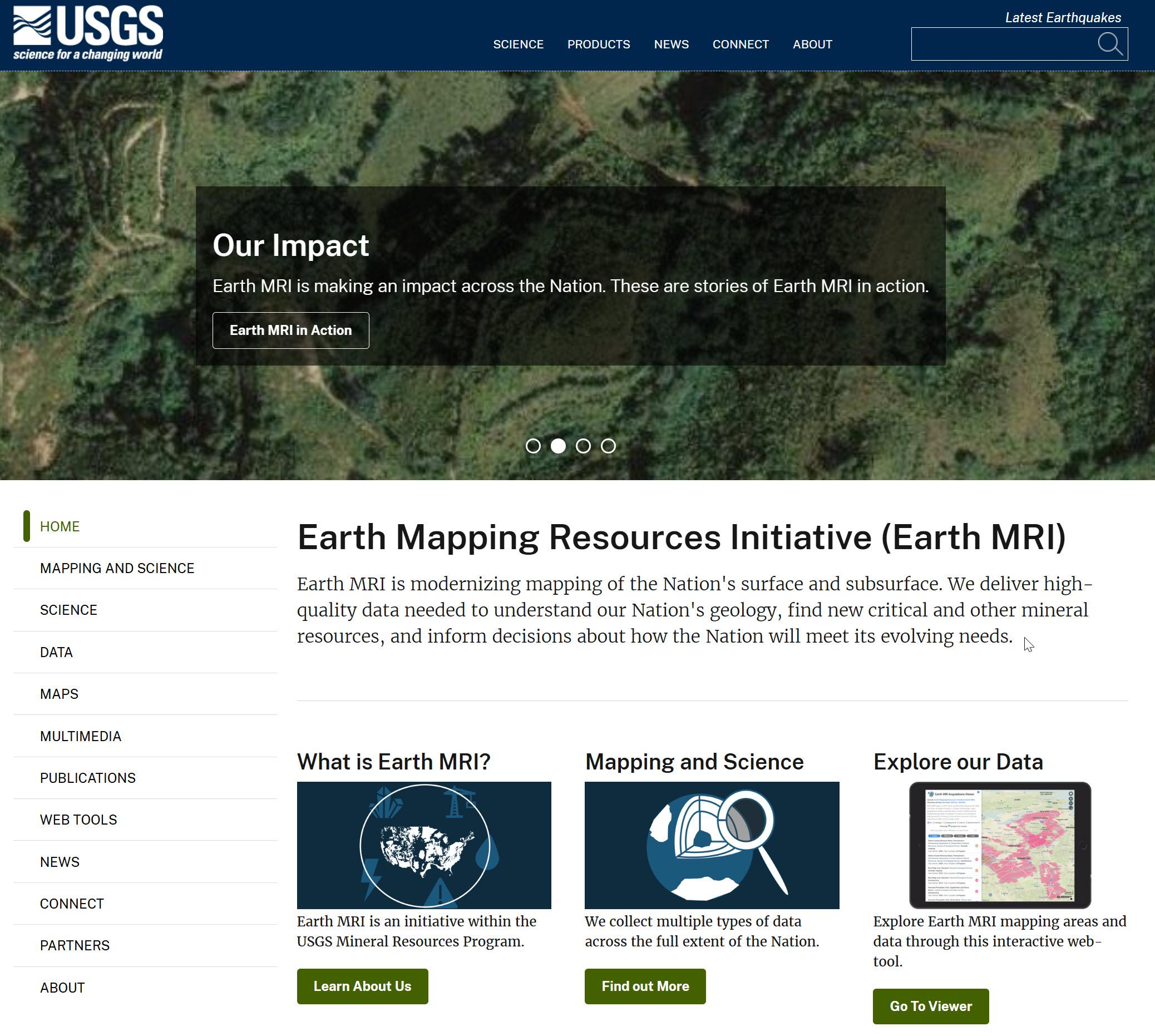
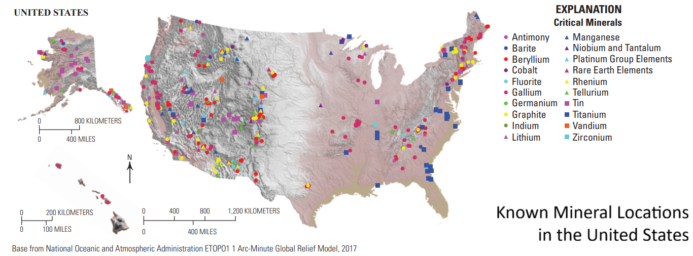
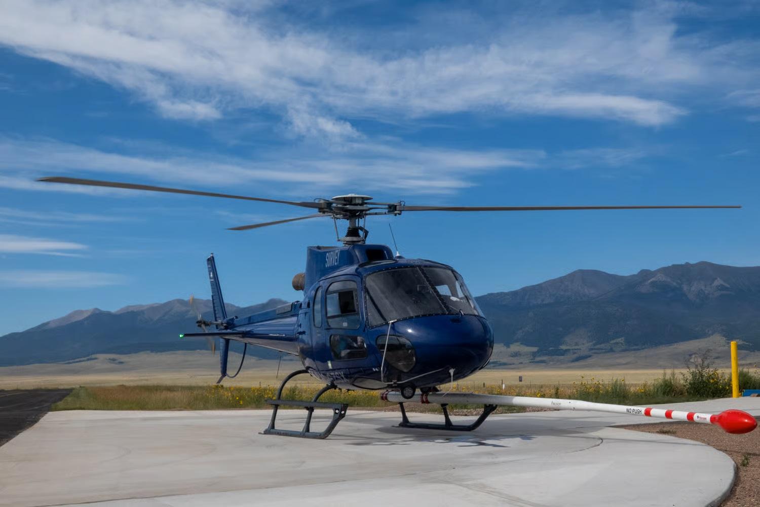
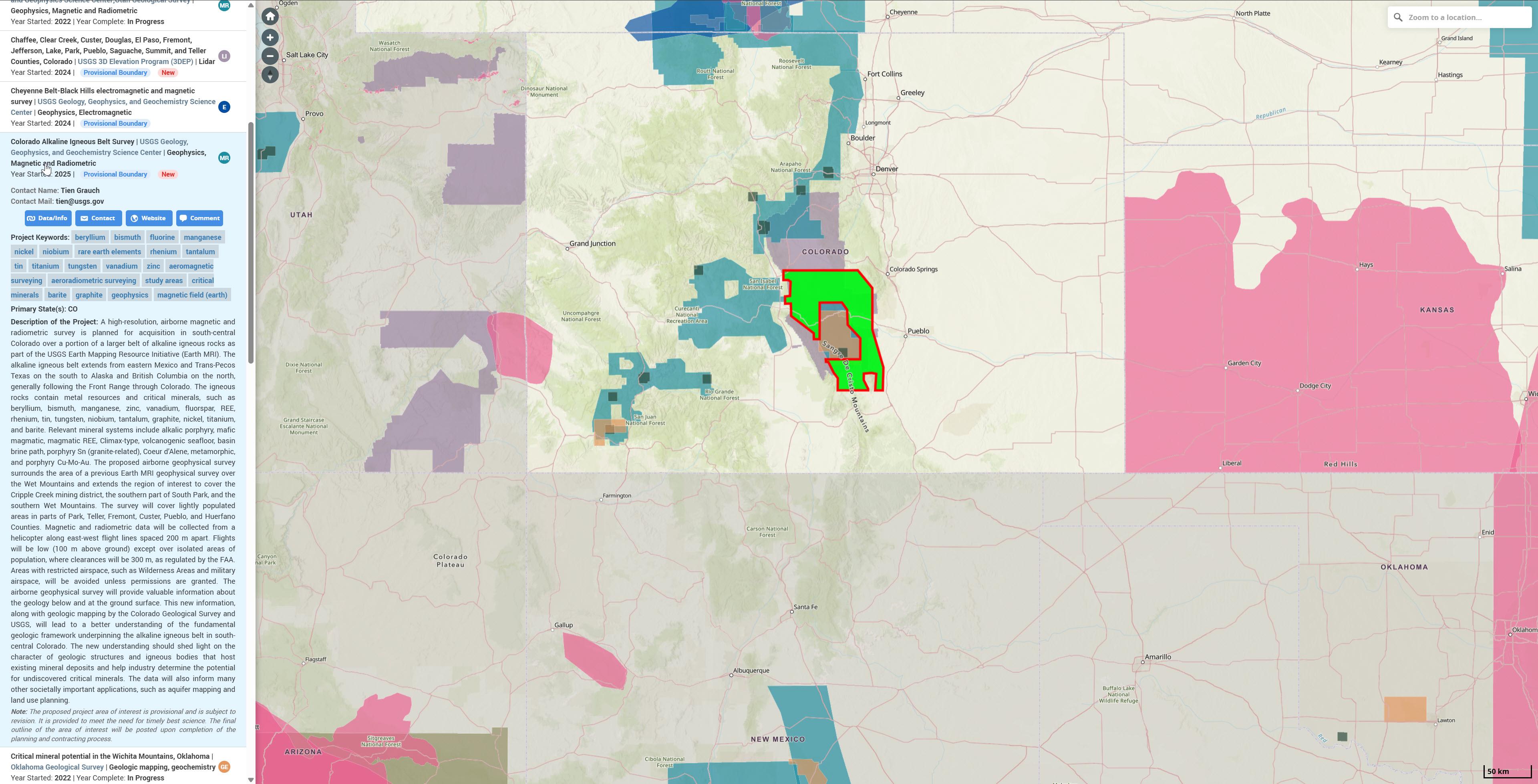
Why Is The Federal Government Spending Millions On Aerial Geological Mapping In Southern Colorado?
--
https://www.cpr.org/2025/11/19/geological-survey-earth-mri-colorado-minerals/ <-- shared media article
--
https://www.usgs.gov/earth-mapping-resources-initiative-earth-mri <-- shared (USGS) Earth Mapping Resources Initiative (Earth MRI) entry page
--
https://ngmdb.usgs.gov/emri/#3/40/-96 <-- shared Earth MRI web map(s)
--
https://www.usgs.gov/centers/gggsc <-- shared USGS Geology, Geophysics, and Geochemistry Science Center entry page
--
https://mrdata.usgs.gov/earthmri/data-acquisition/project.php?f=html&pid=1071 <-- shared USGS Colorado Alkaline Igneous Belt Survey report
--
https://www.usgs.gov/programs/mineral-resources-program/science/what-are-critical-minerals-0 <-- shared final 2025 #DOI / #USGS report on list of critical minerals
--
#geophysics #remotesensing #earthobservation #airborne #mapping #spatial #criticalminerals #colorado #geology #structuralgeology #Colorado #USA #EarthMRI #SouthernColorado #geologicdata #geologicmapping #geochemistry #igneous #survey #geophysicalsurvey #economic #economy #mineral #mineralresources
@CPR @USGS @NV5
#geologicmapping
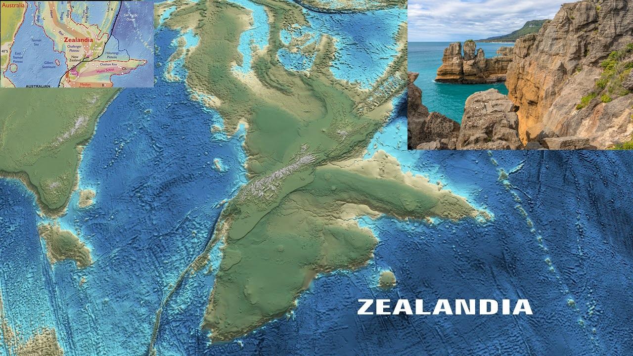
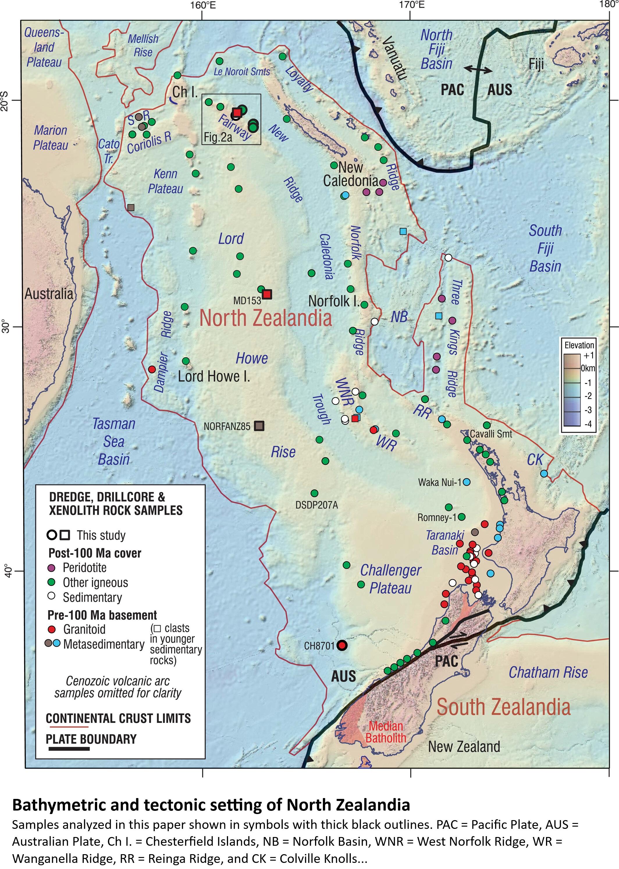
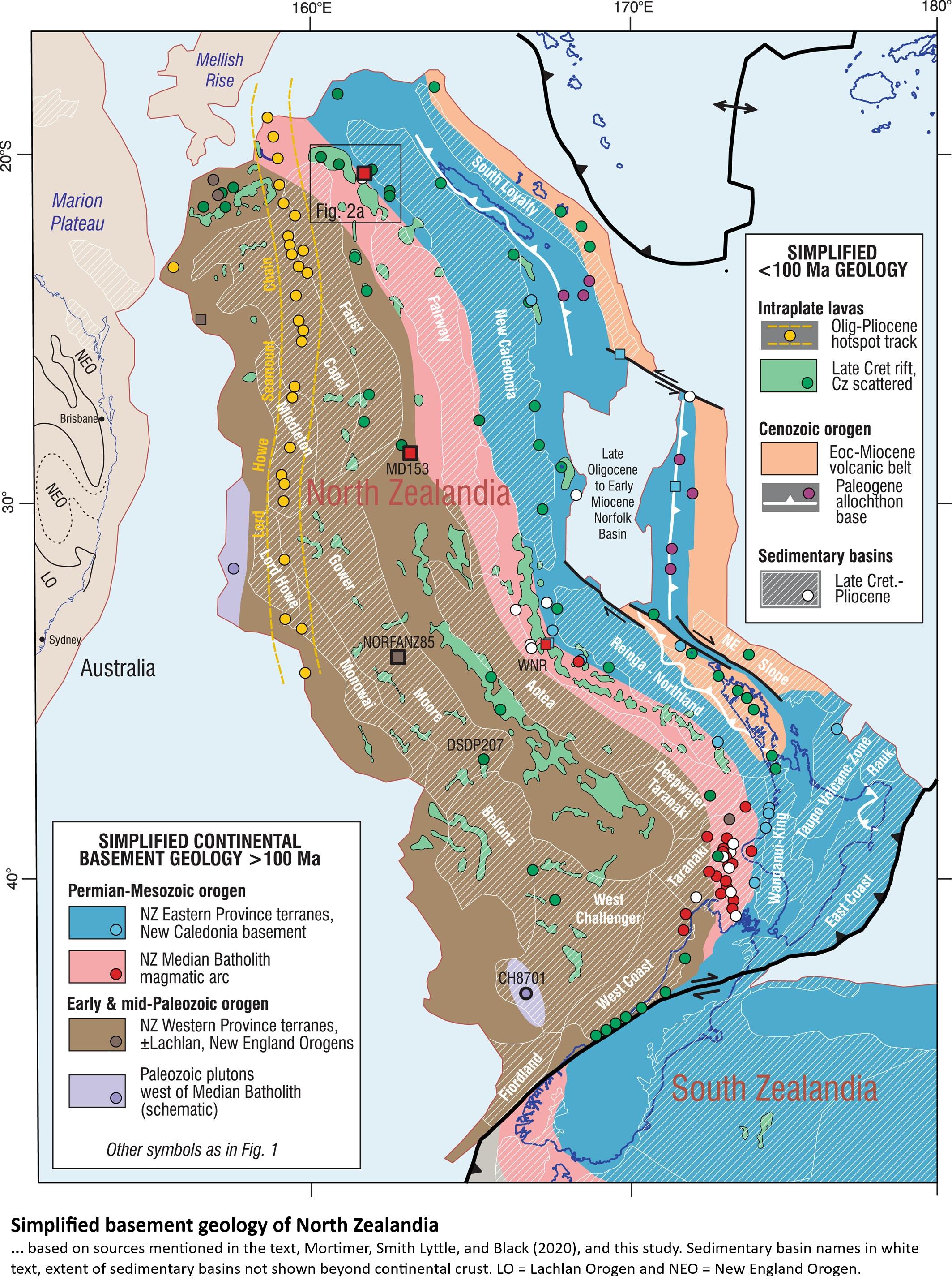
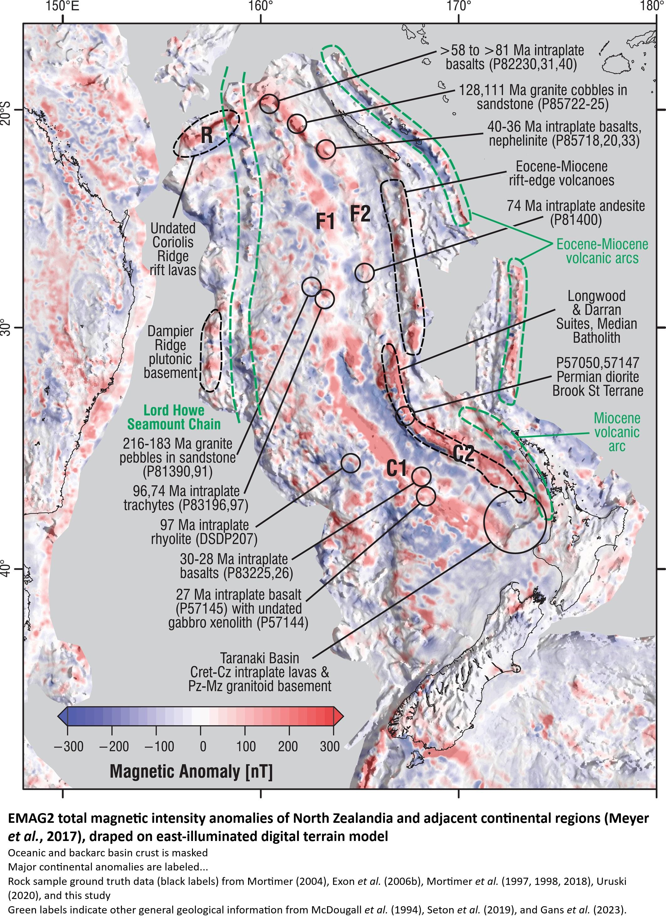
Earth’s 8th Continent Buried Under The Pacific Finally Mapped By Scientists [Zealandia / Te Riu-a-Māui - “Finally”? ~wink~]
--
https://dailygalaxy.com/2025/10/earth-8th-continent-finally-mapped/ <-- shared (somewhat) technical article
--
https://doi.org/10.1029/2023TC007961 <-- shared 2023 paper
--
https://youtu.be/DDbc4K7bgnA?si=EZFmmPFybPLLyND7 <-- shared animation
--
"KEY POINTS
• Basalts and pebbly to cobbly sandstones have been dredged from the Fairway Ridge, Coral Sea
• Dating of the rocks and interpretation of magnetic anomalies allow mapping of major geological units across North Zealandia
• This work completes offshore reconnaissance geological mapping of the entire 5 million square km Zealandia continent…”
#geology #doggerland #Zealandia #TeRiuaMaui #godwana #godwanaland #cretaceous #mapping #geologicmapping #spatialanalysis #model #modeling #NewZealand #SouthPacific #continent #sampling #sediment #dredging #petrography #geochemistry #isotope #analyses #research #cenozoic #intraplate #platetectonics #tectonics #eocene #remotesensing #geophysics #geomagnetism
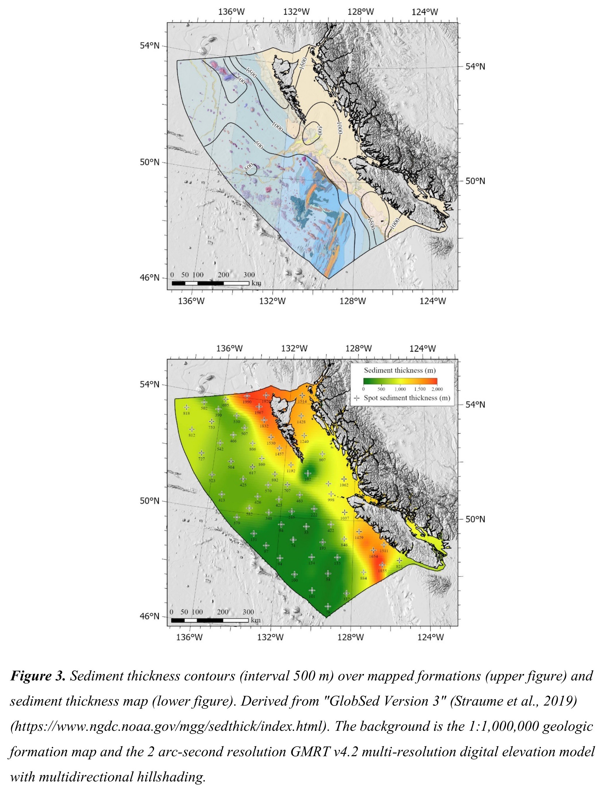
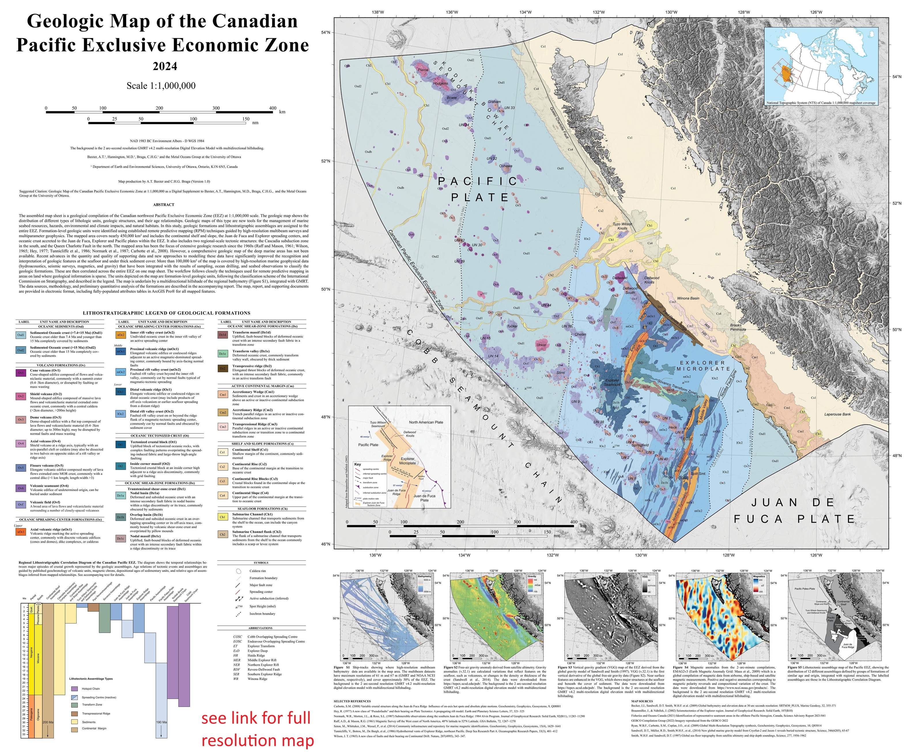
Geological Map Of The Canadian Offshore Pacific Exclusive Economic Zone
--
https://doi.org/10.4095/prfrc4j5xf <-- shared technical article / map
--
[I spent a lot of time living, working and exploring in the PNW – ski bum in Whistler, many dives, offroad motorcycling, engineering geologist, spatial data, cultural + technical + history reading, otherwise exploring, etc – and am fascinated by this area personally and professionally…]
#GIS #spatial #mapping #cartography #remotesensing #Canada #PNW #WestCoast #EEZ #marine #ocean #geology #geologicmapping #opendata #tectonics #ExclusiveEconomicZone #BritishColumbia #PacificNorthwest
@NRCAN

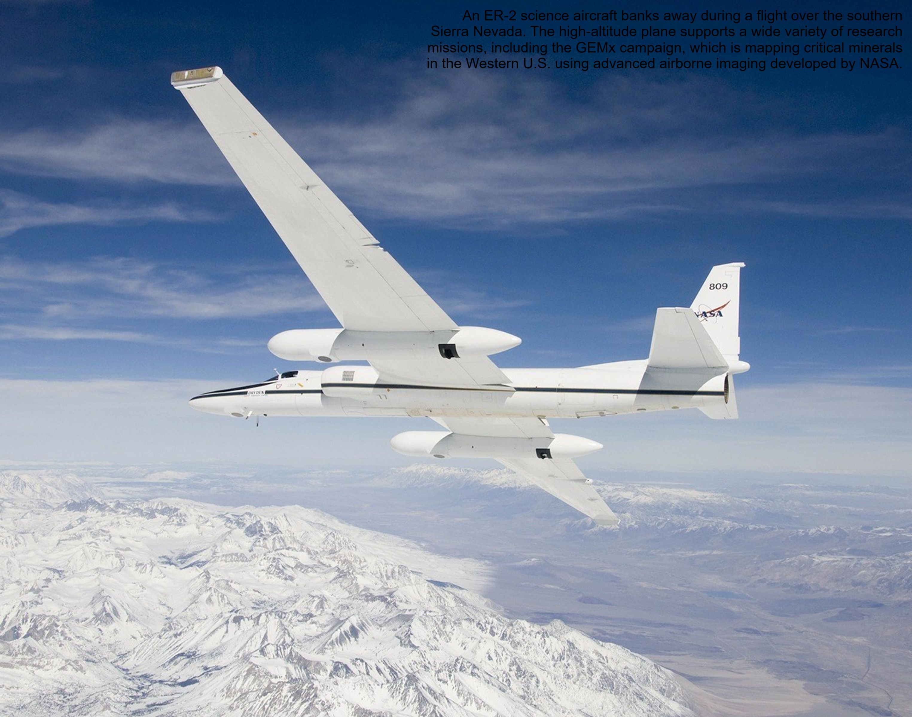
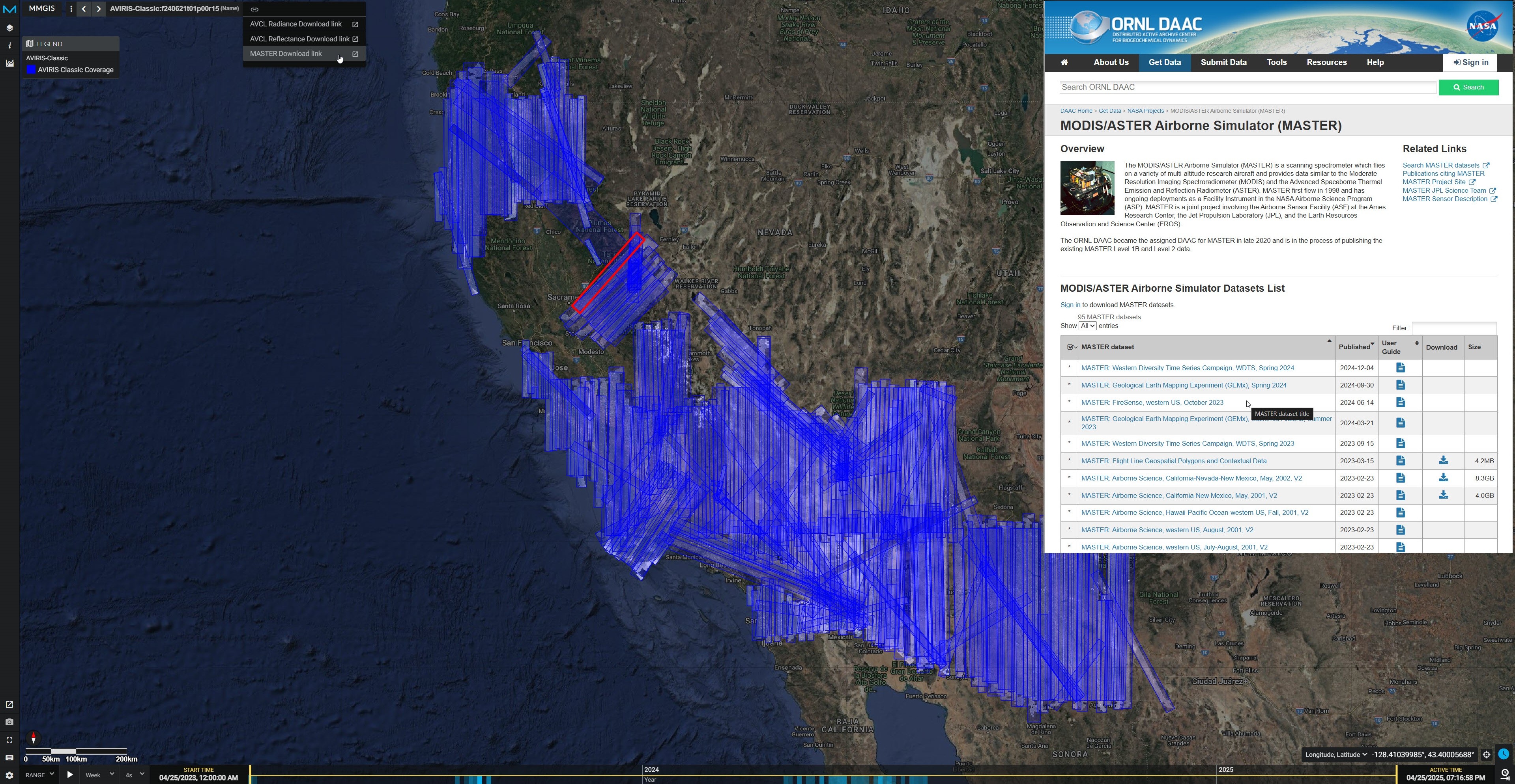
NASA Flights Map Critical Minerals From Skies Above Western US - Technology Used To Chart Other Worlds Is Revealing Minerals In The American West That Are Critical To The Country’s Renewable Energy Future.
--
https://science.nasa.gov/earth/nasa-flights-map-critical-minerals-from-skies-above-western-us/ <-- shared technical article
--
https://popo.jpl.nasa.gov/mmgis-aviris/?mission=GEMx <-- shared GEMx data collection portal
--
#GIS #spatial #mapping #remotesensing #earthobservation #mineral #mineralogy #mining #criticalminerals #USWest #renewableenergy #lithium #GEMx #fedscience #cost #economics #USGS #NASA #GeologicalEarthMappingExperiment #lithium #aluminum #rareearthelements #neodymium #cerium #nationalsecurity #cleanenergy #batteries #smartphones #cellphones #naturalresources #steel #steelmill #dependency #localsources #importing #survey #geology #geologicmapping #exploration #spectrometers #hyperspectral #EMIT #mine #extraction #EarthMRI #opendata
@USGS @nasa

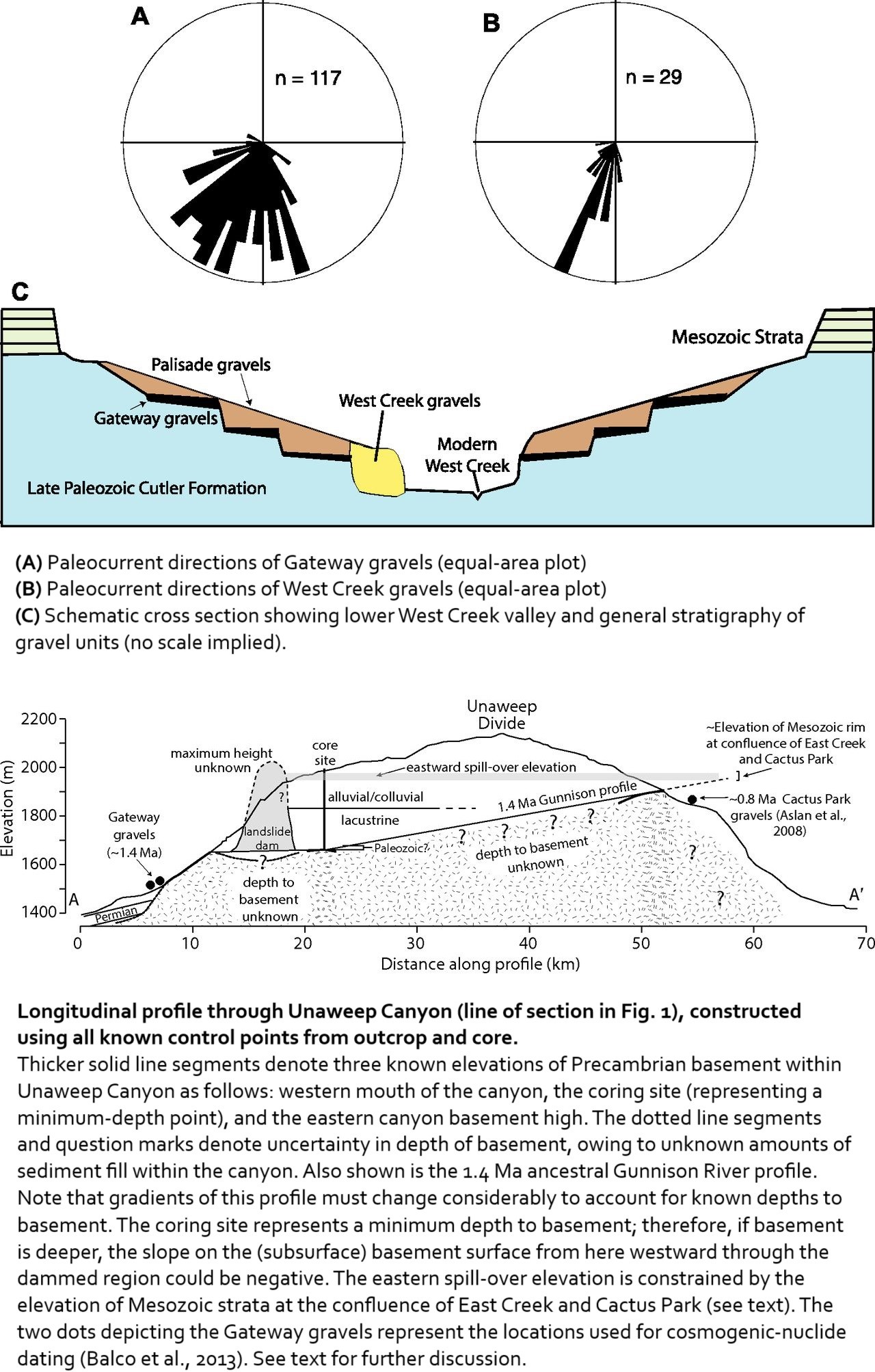
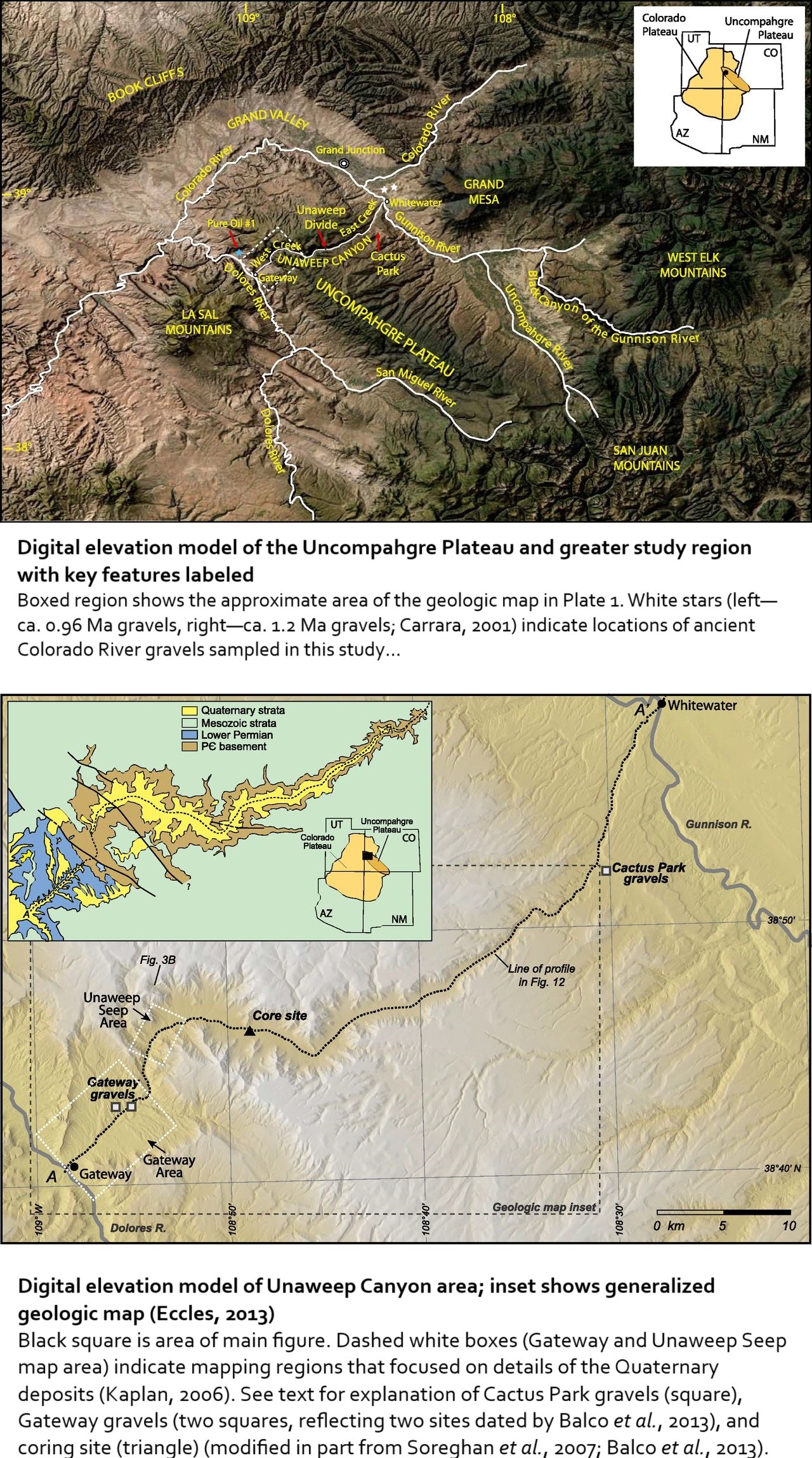
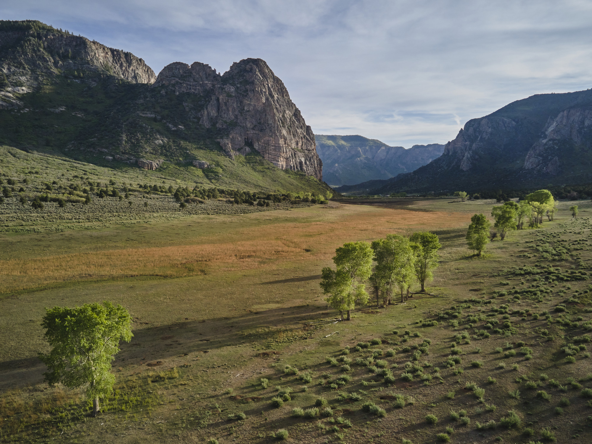
Unaweep Canyon - Two Creeks Flow Out Of Either End Of This [Colorado] Canyon In Opposite Directions
--
https://www.atlasobscura.com/places/unaweep-canyon <-- shared technical article
--
https://doi.org/10.1130/GES01112.1 <-- shared paper
--
[seems like a motorcycle road trip is in order - and happy to visit this beautiful part of the world again]
#geology #colorado #paleovalley #UnaweepCanyon #unaweep #precambrian #unique #divide #water #hydrology #underfit #drainage #EastCreek #WestCreek #Dolores #Uncompahgre #UncompahgrePlateau #erosion #Gunninson #canyon #Tabeguache #mapping #geologicmapping #fieldwork #Cenozoic #gravel #sediment #rockcore #coring #lacustrine #geomorphology #geomorphometry #dating #landform #volcanics #tectonics

Intermountain West Seamless Geologic Map Explorer - National Cooperative Geologic Mapping Program
--
https://apps.usgs.gov/intermountain_west_seamless_geologic_map_explorer/index.html <-- shared web map / app
--
https://www.sciencebase.gov/catalog/item/65cea1c8d34ec3e1801bf74f <-- shared USGS SB details
--
https://doi.org/10.3133/sir20225115 <-- shared SIGMa-GeMS
--
https://doi.org/10.3133/tm11B10 <-- shared GeMS
--
#GIS #spatial #mapping #geology #geologicmapping #USA #USWest #fedscience #usecase #GeMS #SIGMa #opendata #seamless #IntermountainWest #MapExplorer bedrock #surficial #data #NationalCooperativeGeologicMappingProgram #NCGMP #framework #resources #exploration #Strategic #Planning #ProjectDevelopment #ScientificCollaboration #Colorado #NewMexico #interactive #downloadable
@USGS


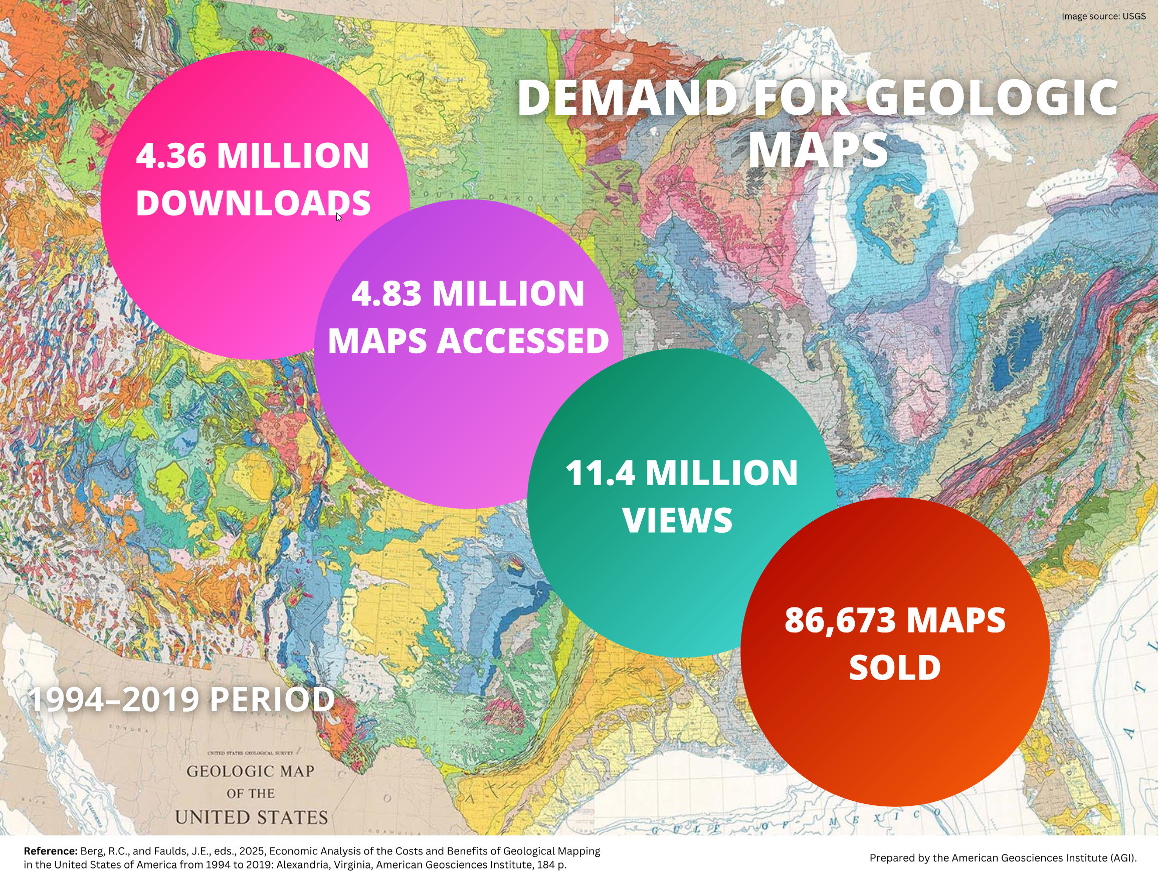
Why Geological Maps Are The Best Investment You’ve Never Heard Of - Investments In Geological Mapping Paid Off Big Time For Americans.
--
https://www.zmescience.com/science/geology/why-geological-maps-are-the-best-investment-youve-never-heard-of/ <-- shared opinion piece
--
https://profession.americangeosciences.org/reports/geological-mapping-economics/ <-- shared technical cost-benefit analysis
--
https://www.geosociety.org/GSA/gsa/positions/position3.aspx <-- shared 2003 GSA appraisal
--
[I am, of course, biased in this regard, but I also like well-presented metrics – and use cases being met are my favourite!]
#geology #value #cost #mapping #cartography #cartographic #USA #costbenefit #geologicmapping #metrics #usecase #fedscience #appliedscience #engineeringgeology #spatial #GIS #construction #resources #naturalresources #engineering #risk #hazard #naturaldisasters #payoff #investment #massmovement #groundwater #waterresources #water #hydrology #rareearth #minerals #mining #oilandgas #exploration #underground #money #economics #publicgood #publicvalue #investment

A Minute-By-Minute Account Of The Pompeii Eruption, Revealed In Agonizing Detail
--
https://www.science.org/content/article/minute-minute-account-pompeii-eruption-revealed-agonizing-detail <-- shared technical article
--
https://doi.org/10.1144/jgs2024-071 <-- shared paper
--
https://doi.org/10.1144/jgs2024-072 <-- shared paper
--
#GIS #spatial #mapping #spatialanalysis #spatiotemporal #timeline #reconstruction #model #modeling #Italy #Naples #Roman #79CE #eruption #volcanic #volcano #geology #engineeringgeology #Campanian #Pompeii #Herculaneum #ancienthistory #eyewitness #history #risk #hazard #naturalhazard #naturaldisaster #publicsafety #Vesuvius #debris #pyroclastic #gas #nueeardente #deposition #Pliny #PlinyTheYounger #geologicmapping #fieldwork #romanempire #impact #cost #economics #infrastructure #lossoflife #deaths


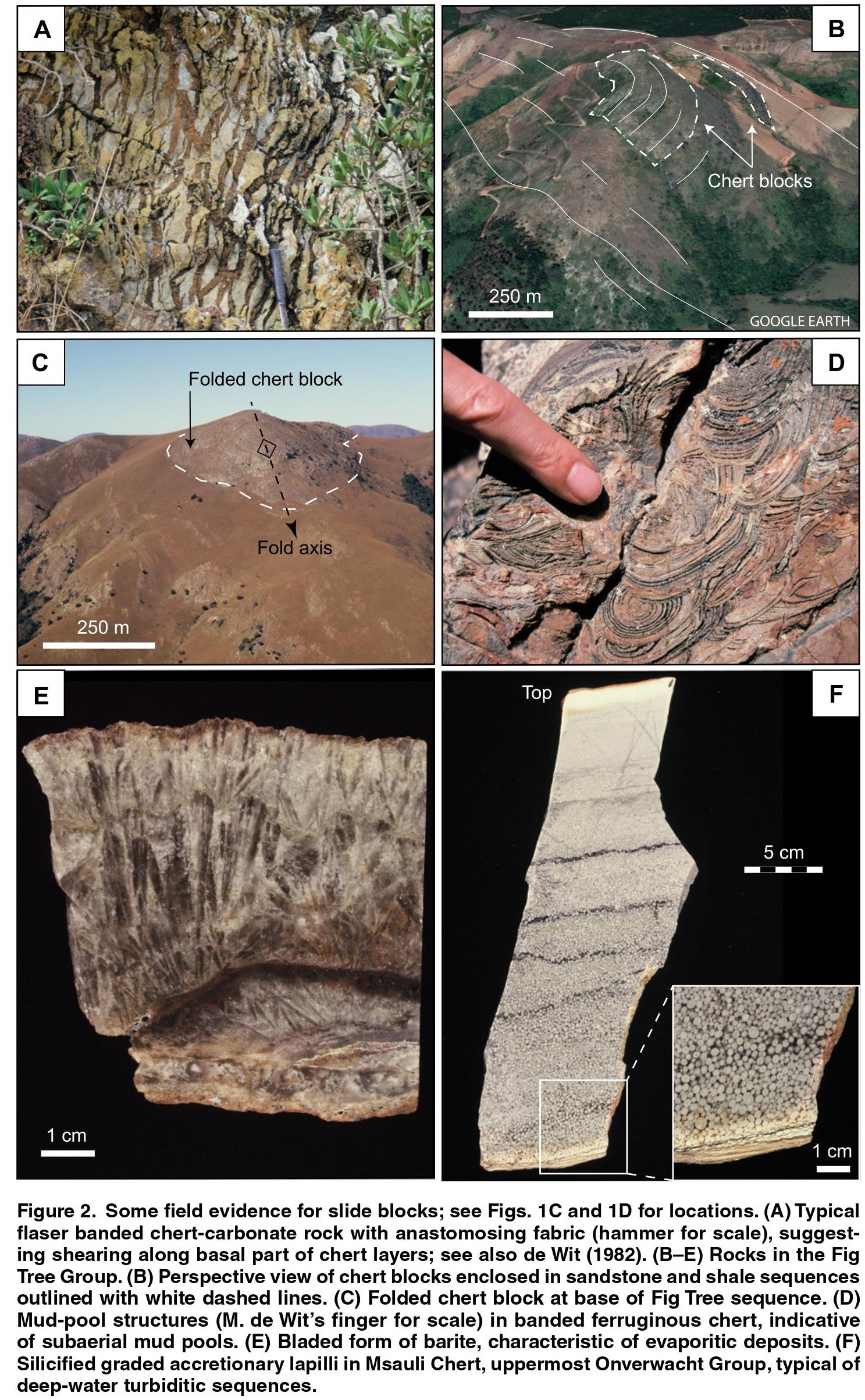
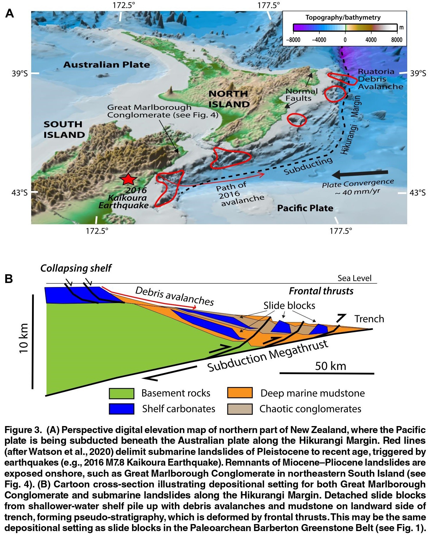
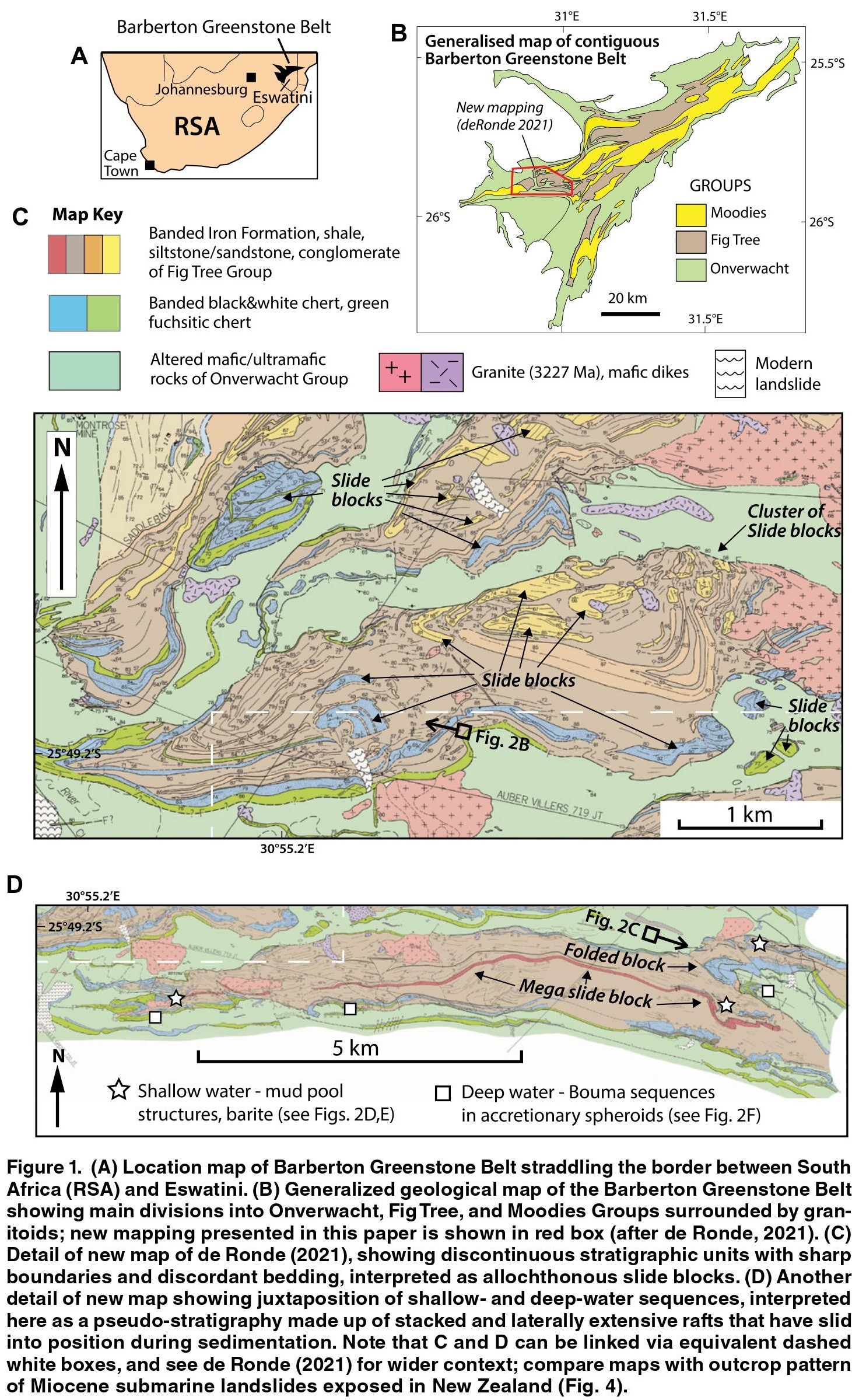
Large-Scale Submarine Landslides In The Barberton Greenstone Belt, Southern Africa—Evidence For Subduction And Great Earthquakes In The Paleoarchean
--
https://pubs.geoscienceworld.org/gsa/geology/article-abstract/doi/10.1130/G51997.1/635654/Large-scale-submarine-landslides-in-the-Barberton <-- shared paper (PDF only)
--
#GIS #spatial #mapping #structuralgeology #SouthAfrica #NewZealand #tectonics #subduction #BarbertonGreenstoneBelt #geologicmapping #geology #earthquakes #paleoarchean #stratigraphy #marine #sedimentation #submarinelandslide #hikurangi #megathrust #superposition

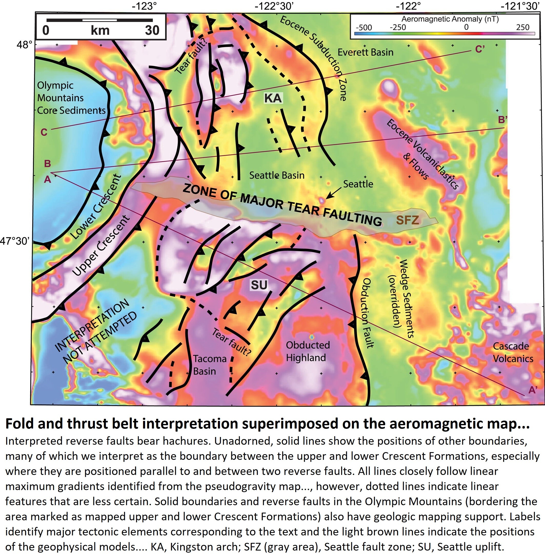
Deep Structure of Siletzia in the Puget Lowland - Imaging an Obducted Plateau and Accretionary Thrust Belt With Potential Fields
--
https://doi.org/10.1029/2022TC007720 <--shared paper
--
[I used to live, work as an engineering geologist and scuba dive in Puget Sound & beyond – including on the expressions of the Seattle Fault…]
#GIS #spatial #mapping #engineeringgeology #Seattle #pugetsound #washingtonstate #fault #faulting #earthquake #tsunami #structuralgeology #PNW #plateboundary #crustal #tectonics #cascadia #forearc #siletzia #seismic #seismichazard #geologichazard #risk #hazard #glacial #sediments #pugetlowland #model #modeling #remotesensing #magnetic #aeromagnetism #gravity #folding #thrust #geologicmapping #geology #seismology #accretionary #obduction #spatialanalysis #spatiotemporal #seattlefault #earthquakehazard #earthquakeengineering

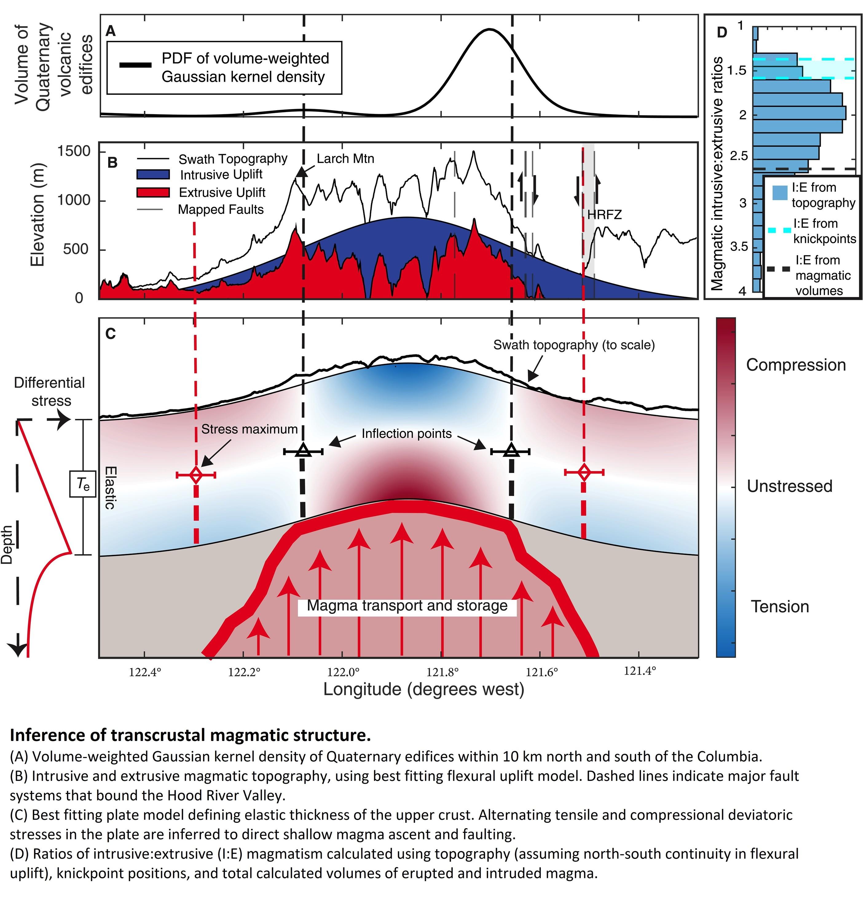
Magma And Mountain Building At The Columbia River Gorge
--
https://www.earthscope.org/news/magma-and-mountain-building-at-the-columbia-river-gorge/ <-- shared technical article
--
https://doi.org/10.1126/sciadv.adj3357 <-- shared paper
--
#GIS #spatial #mapping #remotesensing #GPS #geophysics #subductionzone #plateboundary #PNW #Oregon #columbiariver #geology #structuralgeology #model #modeling #vulcanism #volcanic #magma #fieldwork #igneous #platetectonics #uplift #compression #extension #geologicmapping #geologic #orogeny #mountains #mountainbuilding


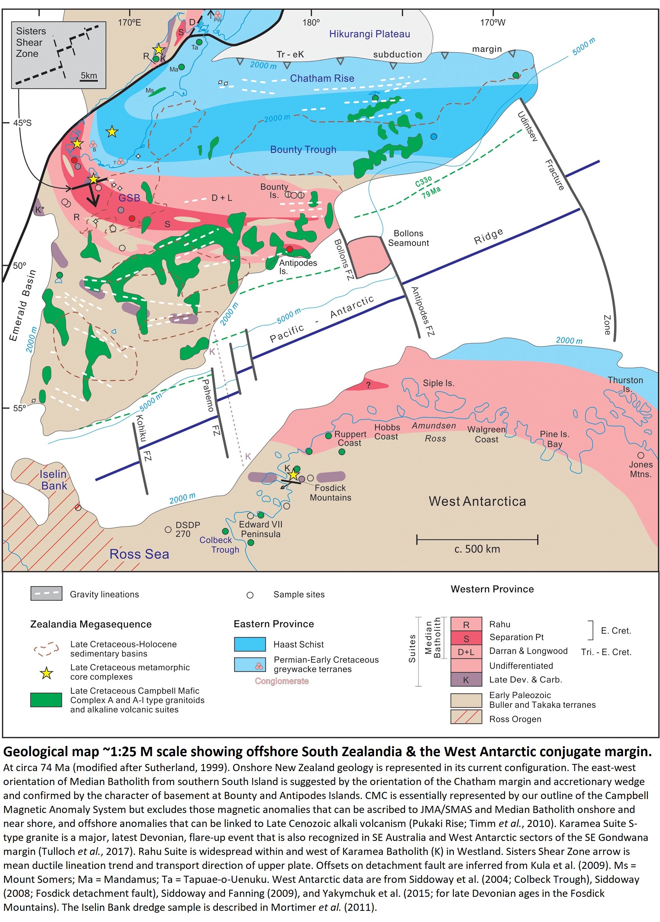
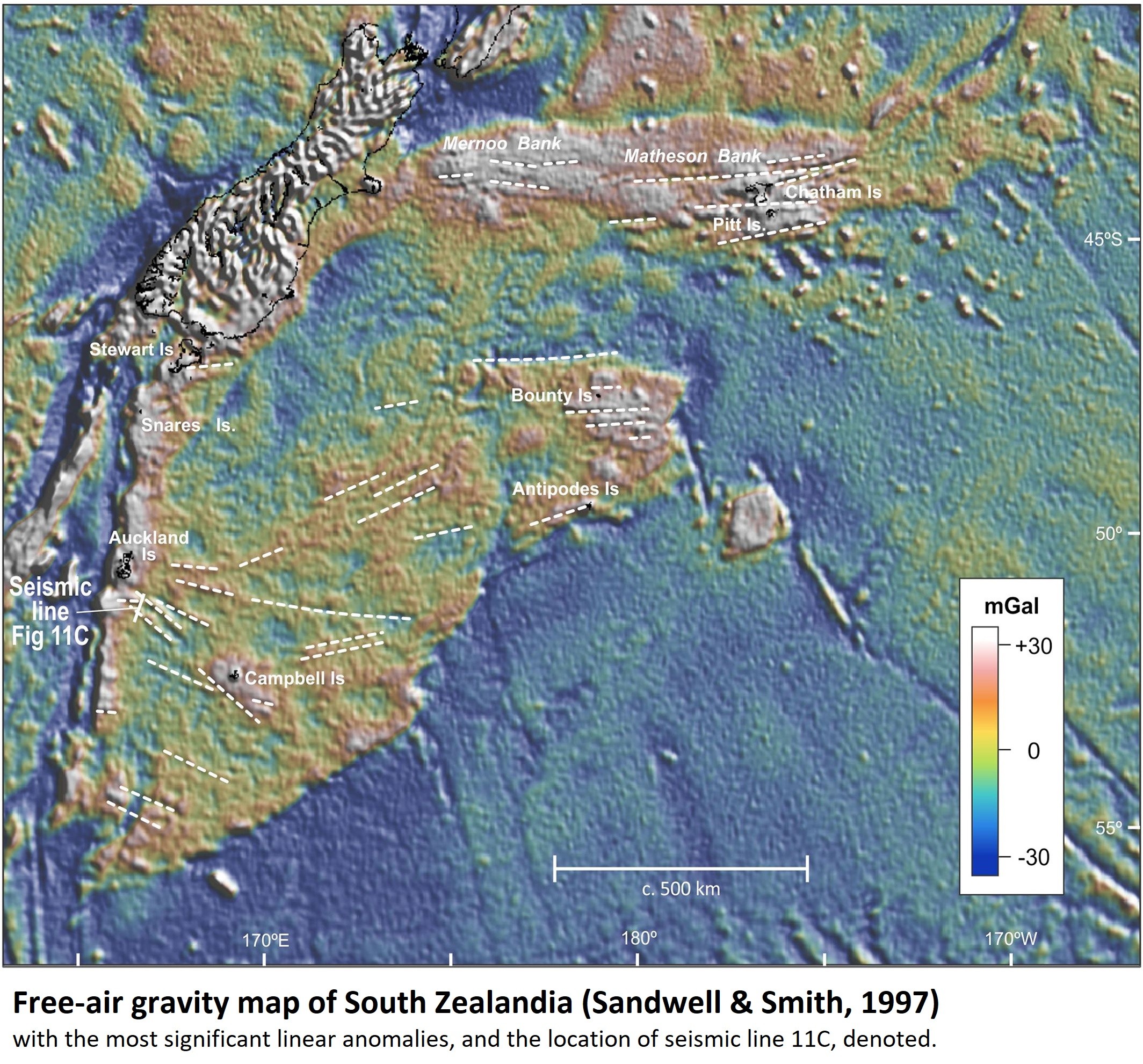
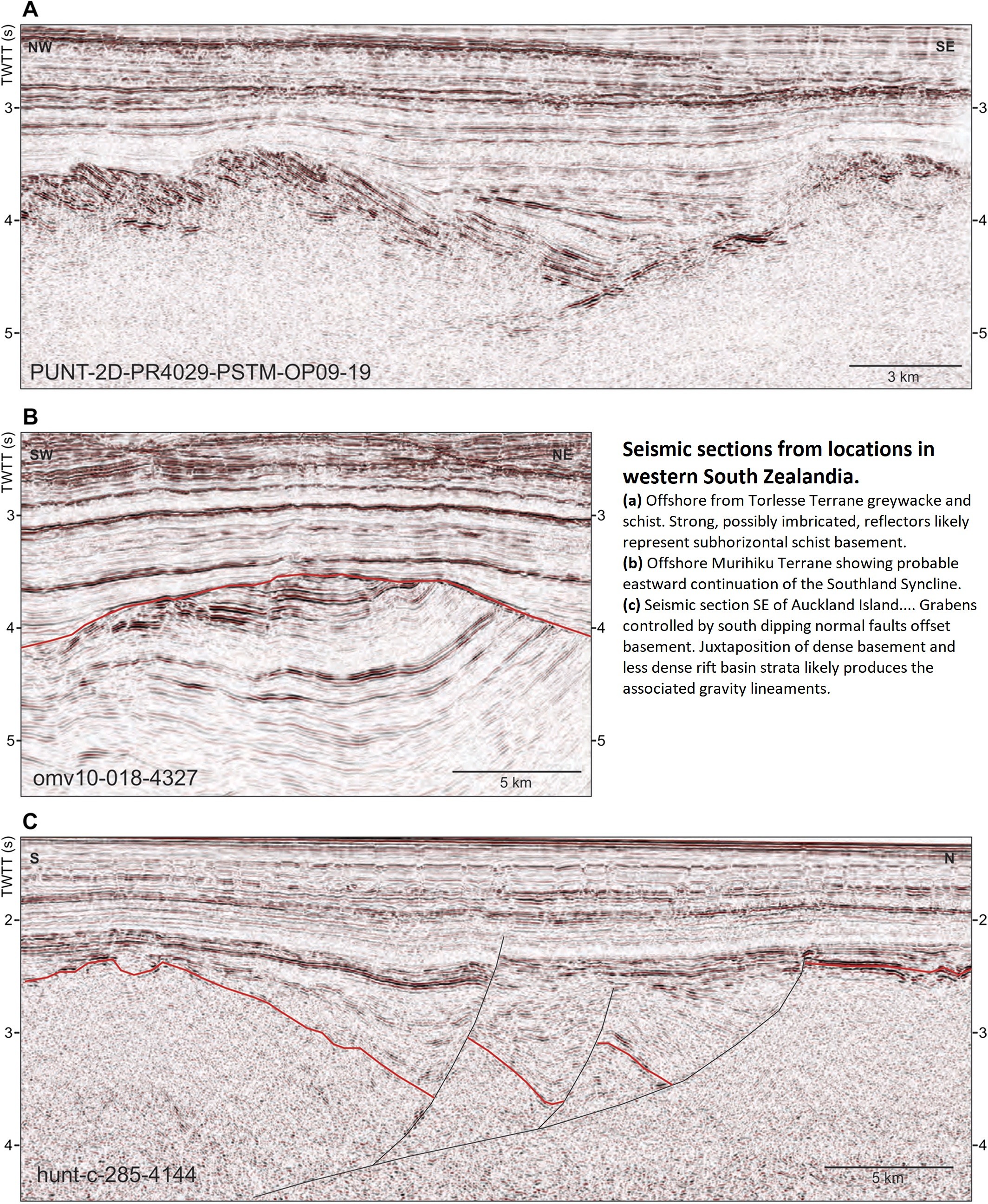
Reconnaissance Basement Geology and Tectonics of South Zealandia
--
https://doi.org/10.1029/2018TC005116 <-- shared paper
--
#GIS #spatial #mapping #geology #structuralgeology #geologicmapping #NewZealand #Zealandia #remotesensing #magnetic #reconnaissance #basement #tectonics #SouthZealandia #igneous #batholith #magneticanomaly #continent #seafloor #bathymetry #orogeny #gondwana ##gondwanaland #sampling #hikurangi #forearcbasin #forearc #boreholes #dredging #faulting #faults #gravity #seismic #seismology #renunitegondwanaland #geophysics
Fantastically Folded Rocks and the Beautiful Butte Fault - A Major Structure in the Grand Canyon
--
https://youtu.be/0yC5tc8KJoI <-- shared video
--
H/T Shawn Willsey
“Hike up scenic Carbon Canyon in the Grand Canyon with geology professor Shawn Willsey to investigate the sexy and magnificent rocks exposed along the Butte Fault. Learn how this fault formed, reversed its direction of movement, and made the East Kaibab Monocline…”
#GIS #spatial #mapping #geological #geologymapping #geologicmapping #fault #faulting #structuralgeology #fieldwork #model #modeling #CarbonCanyon #grandcanyon #USA #ButteFault #folding #rocks
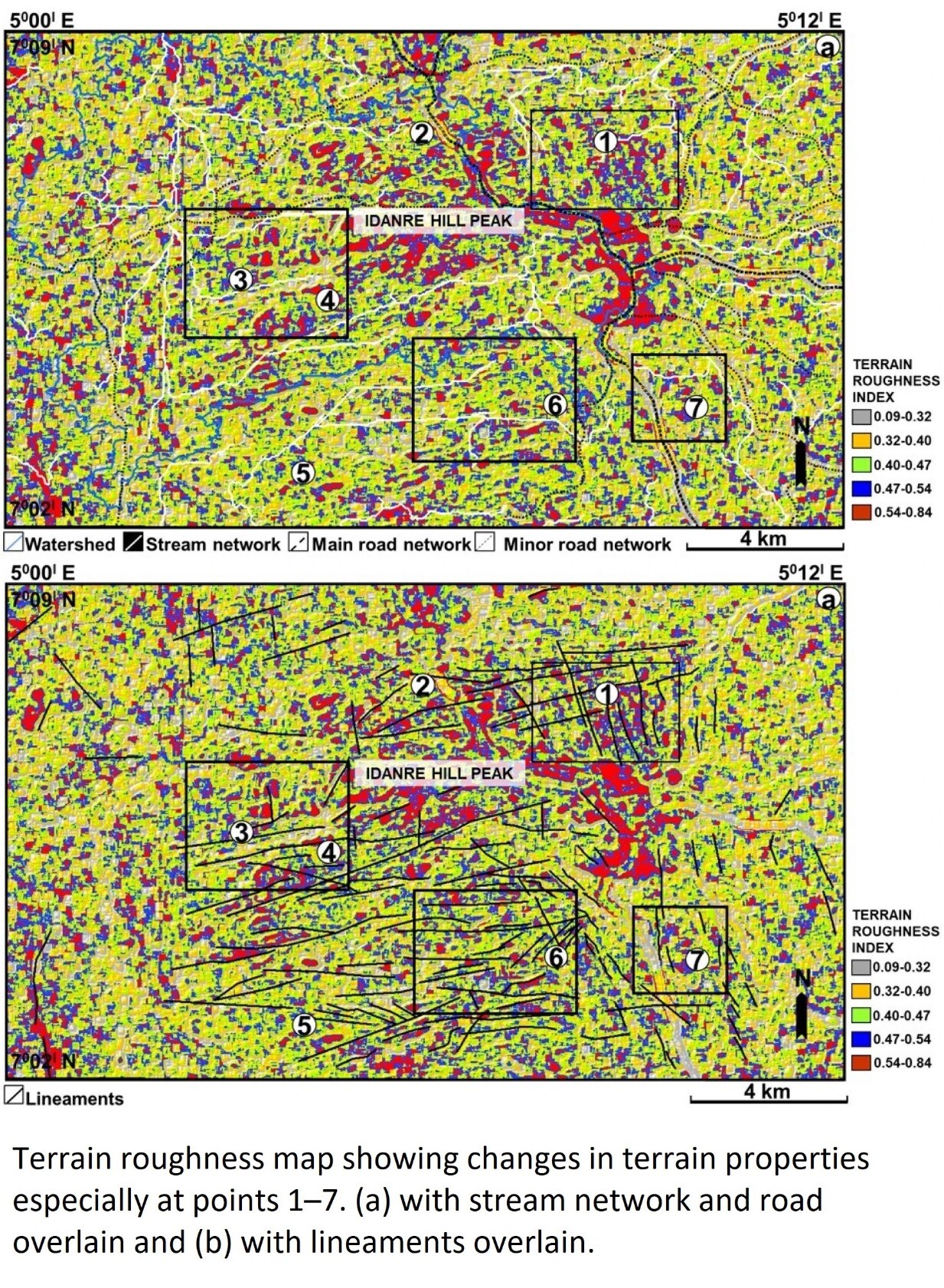
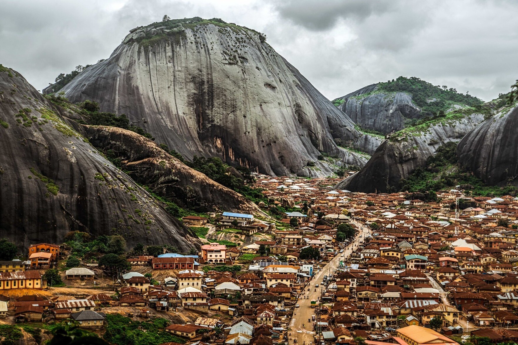
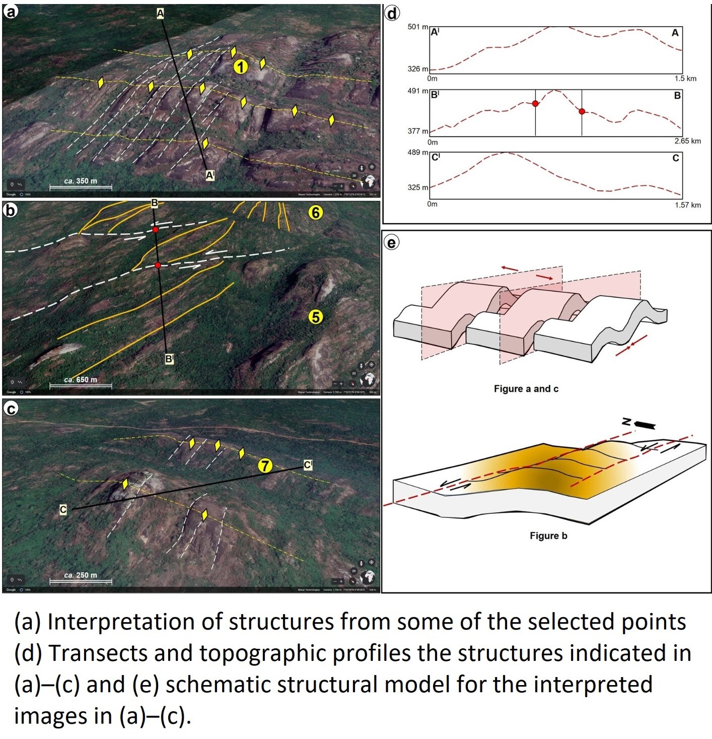
A Simplified GIS And Google-Earth-Based Approach For Lineaments And Terrain Attributes Mapping In A Basement Complex Terrain
--
https://doi.org/10.1038/s41598-022-20057-2 <-- shared paper
--
#GIS #spatial #mapping #imagery #geology #geologic #geological #geologymap #remotesensing #IdanreHills #Nigeria #Africa #spatialanalysis #structuralgeology #network #structural #imagery #lineaments #terrain #methodology #stream #hydrology #geomorphology #roughness #gischat #GoogleEarth #geologicmapping #batholith #gneiss #slope #flowlines #weathering #remotemapping #hillshade #raster

Geologic Map Of The Source Region Of Shalbatana Vallis, Mars
--
https://doi.org/10.3133/sim3492 <-- publication
--
https://pubs.usgs.gov/sim/3492/sim3492_pamphlet.pdf <-- phamplet
--
https://pubs.usgs.gov/sim/3492/sim3492_sheet.pdf <-- high resolution map
--
https://pubs.usgs.gov/sim/3492/sim3492_XantheTerra_GISFiles.zip <-- GIS files for download
--
#GIS #spatial #mapping #gischat #map #Mars #solarsystem #elevation #geology #geomorphology #XantheTerra #download #GISData #opendata #landforms #geologicmapping #geological #hydrology #water #flood #flooding #extraterrestrial #remotesensing #THEMIS #satellite #orbiter
#USGS

I am beyond thrilled to share that I've accepted the position of Hazards Geologist with the #Oregon Department of Geology and Mineral Industries (aka #DOGAMI), based in the #Portland office.
So excited to join a great team and for the opportunity to continue to grow and learn as a research scientist with a focus on furthering #seismichazard and #geologicmapping programs throughout the state.