
Historic England Asks For ‘Ghost Sign’ Photos To Create Online Map
--
https://www.theguardian.com/culture/2023/oct/27/historic-england-ghost-sign-photos-halloween-online-map <-- shared media article
--
https://historicengland.org.uk/whats-new/features/ghost-signs/ <-- Historic England Ghost Signs Overview & Online Map
--
“They are haunting reminders of a bygone age, some so faded the writing can hardly be deciphered, others still vivid reminders of the colour and variety that high streets once had.
Over [the 2023] Halloween weekend, Historic England [was] asking people to help record the “ghost signs” still to be found on buildings across England and send them in for an online map..."
#GIS #spatial #mapping #UK #Britain #England #signage #sign #onlinemapping #communityengagement #community #collaboration #highstreet #mainstreet #commercial #industrial #ghostsigns #ghostsign #advertising #handmade #handpainted #HistoricEngland #history #urban #urbanhistory #tracking
@Historic England
#onlinemapping


Soar | The New Atlas
--
https://soar.earth/maps <-- SOAR home page
--
[sharing the details of this web page / service does not constitute an endorsement]
“A digital atlas for all the world's maps and imagery ##
Soar is the world's largest online atlas, and the home of maps on the internet.
[Their] platform allows anyone in the world to view, upload, discover, and interact with an enormous library of high quality maps and images. We’re bringing together every map, satellite, and drone image that has ever existed, or will ever exist, in one place…”
#GIS #spatial #mapping #webmapping #global #resource #remotesensing #clearinghouse #online #onlinemapping #spatialdata #map #satellite #drone #imagery #spatialanalysis
@Soar_Earth


A Decade After A Disastrous Launch, Is Apple Maps Finally Good?
--
https://www.theguardian.com/travel/2023/aug/09/apple-maps-cycling-transport-google <-- shared media article
--
#GIS #spatial #mapping #cartography #onlinemapping #dataquality #AppleMaps #quality #improvement #navigation #spatialdata #datacollection #updates #realtime #gischat #Apple
@apple


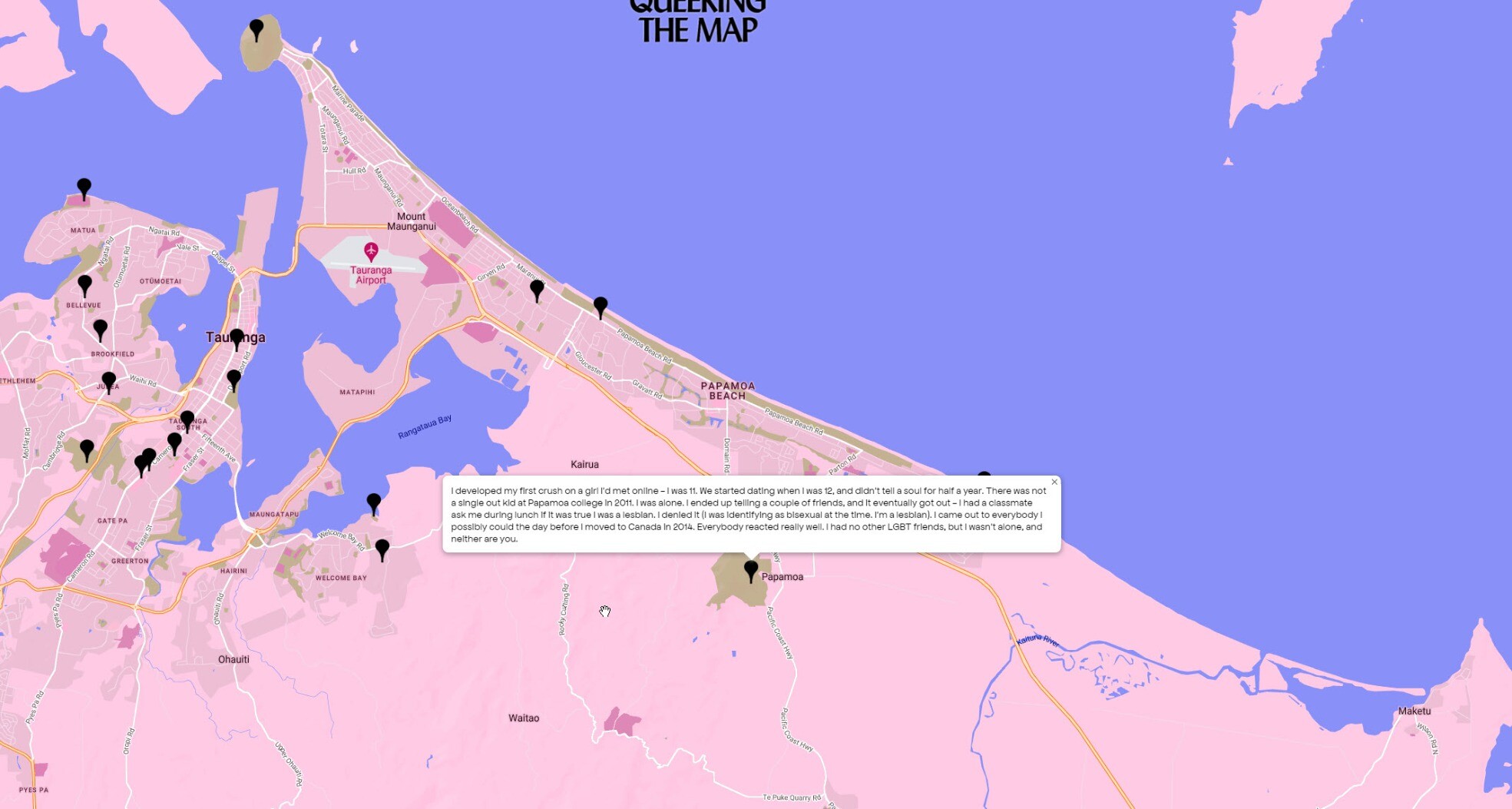
Just Made A Queer Memory? Drop A Pin [community mapping]
--
https://www.nytimes.com/2023/06/25/style/queering-the-map-lucas-larochelle.html <-- shared media article
--
https://www.queeringthemap.com/ <-- web site
--
#GIS #spatial #mapping #communitymapping #lgbtpride #lgbtq #lgbtqcommunity #lgbtqplus #pridemonth #pride2023 #pridemonth2023 #pridecommunity #anonymous #anonymity #experience #community #digital #people #project #media #QueeringTheMap #culture #experinces #memories #cartography #onlinemapping #onlinemap #gischat #archive #affinity #connections #global #world


UNVT Portable - Portable MapServers For Disaster Response
--
https://github.com/unvt/portable
--
" ‘UNVT Portable’ is a package for RaspberryPi that functions as a map hosting server and can be freely accessed from a web browser within a local network.
It is mainly intended to function in an offline environment during times of severe disaster, and is expected to play an active role... where disaster response headquarters are set up to assess the situation and respond to disasters by combining aerial drone images taken after a disaster occurs with OpenStreetMap and various open data tile data sets prepared in advance…”
#GIS #spatial #mapping #gischat #portable #mapserver #raspberrypi #raspberry #hosting #server #webbrowser #localnetwork #onsite #disasterresponse #hardware #solution #opensource #openformat #responsecenter #disasterresponsecenter #headquarters #readyresponse #mobile #mobileoffice #emergencyresponse #emergencymanagement #emergencypreparedness #risk #hazard #onlinemapping


Scientists Unveil Mass Online Mapping Tool Revealing Marine Life On Ocean Floors [Seamap Australia]
--
https://www.abc.net.au/news/2023-05-23/public-access-to-imas-marine-mapping-tool-for-sea-floor/102377580 <-- shared media article
--
https://seamapaustralia.org/map/ <-- Seamap Australia - National Marine Benthic Habitat Map
--
#GIS #spatial #mapping #Australia #Seamap #opendata #crowdsourcing #repository #marine #benthic #habitat #hydrospatial #bathymetry #data #community #research #university #science #onlinemapping #webmap #dataportal #seafloor #marinescience #oceanography #spatialanalysis #gischat
@seamap


BlueTopo – A Curated Collection Of High Resolution Seafloor Models [NOAA]
--
https://www.nauticalcharts.noaa.gov/data/bluetopo.html <-- shared article
--
https://nowcoast.noaa.gov/ <-- open data access via #NowCoast web map
--
https://registry.opendata.aws/noaa-bathymetry/ <-- NOAA National Bathymetric Source Data
--
#GIS #spatial #mapping #remotesensing #sonar #opendata #openaccess #water #marine #data #BlueTopo #bathymetry #hydrospatial #hydrography #bathymetric #onlinemapping #nautical #charting #navigation #ocean #sea #seafloor #highresolution #model #modeling #lakebeds #USWaters #oceanscience #oceanengineering #oceaneconomy #economics #forecasting
@NOAA @NOAA Office of Coast Survey


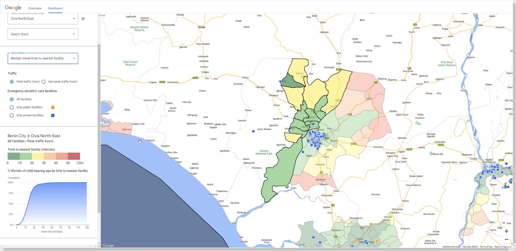
How [Google Is] Supporting Access To Emergency Maternal Care In Nigeria
--
https://blog.google/intl/en-africa/company-news/technology/supporting-access-to-emergency-maternal-care/ <-- shared blog post
--
https://emergencyobstetriccare.webapps.google.com/dashboard <-- dashboard
--
#GIS #spatial #mapping #routes #spatialanalysis #Nigeria #appliedscience #medical #maternal #emergency #obstetrics #obstetricsandgynecology #emergencyservices #health #publichealth #africa #google #travel #primarycare #onlinemapping #dashboard #gischat #maternitycare #maternity #womanshealth #maternalchildhealth
@Google


If The Ancient Romans Had Google Maps - Omnesviae Is A Modern Route Planner Based On The Roads Of The Roman Empire
--
https://bigthink.com/strange-maps/omnesviae-roman-roads-map/ <-- shared article
--
https://www.omnesviae.org/ <-- OmnesViae - Roman RoutePlanner
--
[combining professional and personal interests]
#GIS #spatial #mapping #gischat #network #webmap #romanempire #ancientrome #ancienthistory #transportation #infrastructure #roads #commerce #military #OmnesViae #routing #publicroads #TabulaPeutingeriana #history #ancientmaps #historicmaps #itinerarium #peutingermap #onlinemapping #onlinemap


Indigenous Sites In Melbourne - Interactive Map Reveals What The City Was Like Before Colonisation
--
https://www.theage.com.au/national/victoria/revealing-naarm-interactive-map-reveals-hidden-indigenous-histories-of-major-sites-20230411-p5czny.html <-- shared article
--
https://aboriginal-map.melbourne.vic.gov.au/95 <-- shared web map
--
#GIS #spatial #mapping #painting #melbourne #people #Australia #onlinemapping #Aboriginal #culture #history #sites #colonisation #indigenous #indigenouspeoples #firstnations #spatialdata #heritage #ceremonial


Robinson Projection In Tableau – Do Mo(O)Re With Data
--
https://domoorewithdata.com/2022/08/15/robinson-projection-in-tableau/ <-- shared tutorial
--
H/T Brian Moore @BMooreWasTaken
“[Their] post walks through three different techniques for creating Robinson Projections in Tableau including; using Shapefiles to map countries, using a CSV file to map countries, and using a CSV file to map cities..”
#GIS #spatial #mapping #tutorial #onlinelearning #learning #projection #robinson #RobinsonProjection #tableau #online #onlinemapping


