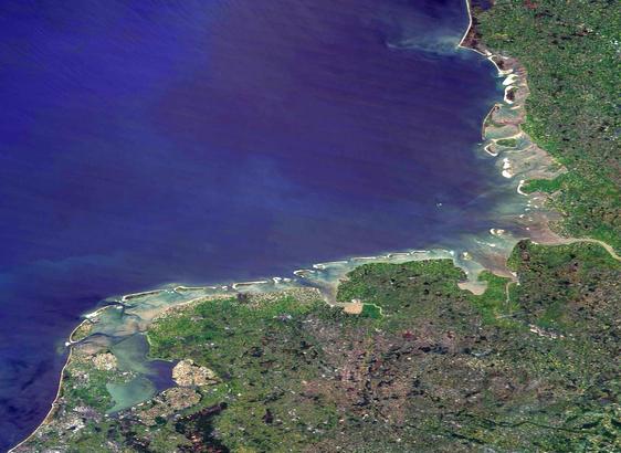
Vadehavet i hele sin udstrækning fra Blåvandshuk til Den Helder i NL i går d. 12. maj, hvor der stort set var skyfrit i hele området. Fra NASA's gode gamle Terra-satellit, hentet via #Worldview #Earthdata og farve-justeret i IrfanView.
Fordi det lige passede ind, og vi trænger til noget pænt at kigge på.
Og så er det for resten #UNESCO Verdensarv, så vi er forpligtet til at passe godt på det!
#earthdata
Free earth science/GIS tools from NASA:
https://www.earthdata.nasa.gov/data/tools
#GIS #search #earthScience #Worldview #Vertex #Giovanni #SAR #FIRMS #Earthdata
Pumping of ground water has tilted the earth and affected its rotation.
#EarthData
https://www.yahoo.com/news/earth-tilted-31-5-inches-164500379.html
Do you work for a U.S. State, Tribe, or Territory and use or want to use NASA Earth observation data for decision-making? NASA is looking for feedback on the impact, gaps, challenges, and future priorities! Click the link below to take the survey and provide your feedback. https://cfigroupfed.gov1.qualtrics.com/jfe/form/SV_2mWT4UVbZr4qnpI
Hydrology Data Products from the SWOT Mission [vodcast]
--
https://podaac.jpl.nasa.gov/animations/Hydrology-Data-Products-from-the-SWOT-Mission <-- shared technical resource / podcast / video
--
https://swot.jpl.nasa.gov/ <-- NASA SWOT homepage
--
https://swot.jpl.nasa.gov/science/publications/ <-- shared papers related to SWOT
--
#GIS #spatial #mapping #remotesensing #SWOTsatellite #Hydrology #RemoteSensing #GoSWOT #NASA #CNES #Rivers #Lakes #PixelCloud #Raster #podcast #opendata #SWOT #earthdata #earthobservation #water #hydrology #oceans #wateresources #watermanagement #marine #oceangraphy
@nasa
Articlehighlight Baltimore and Maryland contributions on the Plankton, Aerosol, Cloud, ocean Ecosystem (PACE) missiom that launched in February.
It will uses colors to study vegetation in the oceans and on land; and polarimeters to study aerosols to track the ocean-atmosphere interaction
Four new proposals for Earth Science missions have been selected for the next step!
The proposals study gases in the troposphere and mesosphere, measure ocean surface currents and winds, observe the structure of ecosystems and glaciers, and monitor greenhouse gases.
Of these, two will be selected after further design work with an aim to launch in 2030 or 2032 - this is one of the first steps in a long process!
NASA’s Science Discovey Engine is increasing access to environmental justice data
#earthday #earthdata #OpenScience
https://www.earthdata.nasa.gov/news/new-resource-speeds-access-environmental-justice-data
Rest in Peace Paul. Pål Wessel - #EarthData #DataLeader. https://groups.google.com/g/AGU-Informatics/c/WaymBLEAbxc/m/4B1ovao0AwAJ
"An Open Information Platform on Greenhouse Gases for the United States" concluded our year with a focus on environmental transparency. #ghg #greenhousegas #emissions #satellites #earthdata #nasa
🔗 https://developmentseed.org/blog/2023-12-14-ghg-center
The new Science Explorer (SciX) launches today! This provides search over publications related to Earth and Space Science. It builds on the Astrophysics Data Service to expand similar services of discovery to Earth, Planetary, Heliophysics and Space-based biological and physics sciences.
#OpenScience #Astrodon #EarthData #PlanetaryScience #climatechange #Heliophysics #AGU
Welcome to the team Zac!
Learn more about product manager Zac Deziel (@zacdezgeo) who is leading out our work on eoAPI: https://developmentseed.org/blog/2023-11-01-welcome-zac
UAH computer scientists are contributing to global efforts in earth data management and computing collaboration. Learn about their role in advancing environmental data use and sharing. #EarthData @NASAEarthData @UAHuntsville
🛬 Touchdown in Lima!
Lilly Thomas & Ryan Avery meet up with Ruben Mendoza & Junior Flores Martinez to teach a TensorFlow for Earth Science training with SERVIR-Amazonia and Conservación Amazónica – ACCA
#machinelearning #tensorflow #earthscience #earthdata #remotesensing
Working together with IBM, NASA has released an open-source geospatial artificial intelligence (AI) foundation model for Earth observation data. This is based on Landsat Sentinel-2 data set and has a range of potential applications.
If you want to see what is potentially possible, I would suggest checking out some of the demos at the end of the article.
#NASA #IBM #OpenScience #AI #EarthData
Article: https://www.earthdata.nasa.gov/news/impact-ibm-hls-foundation-model
Hugging Face Community: https://huggingface.co/ibm-nasa-geospatial
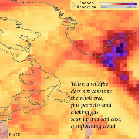
Canadian wildfires export carbon monoxide, day and night, sending this deadly cloud East past Greenland. Carbon monoxide pollutes the atmosphere for roughly one month/ #climate #wildfires #CO #carbon #choking #NASA #EarthData #AIRS3STM museumzero.art
How simple the hurricane seems, seen from a satellite, but how wet it is, down below, drifting toward Baja--
Hurricane Adrian, moving north toward Baja California, July 2, 2023. #truecolor #precipitation #worldview #earthdata #NASA #ModisAqua #visualpoem #UI #EOSDIS
We are launching #SpatiaFi!
SpatiaFia collects, processes, and merges massive amounts #EarthData and #asset #location data, like a farmer’s field or a highway, conditions can be monitored and analysed in near-real time to understand the risks and impacts of #climate events like #floods or #wildfires before, during, and after they occur.
More information to come!
https://youtu.be/k4S2G7Er3gA
Really excited to see the awardees for the Data, Equity, Equity, and Access program. The awards to 8 Histoically Black Colleges and Universities will enable innovative data science research that will contribute to NASA missions.
https://www.nasa.gov/press-release/nasa-awards-millions-to-historically-black-colleges-universities


