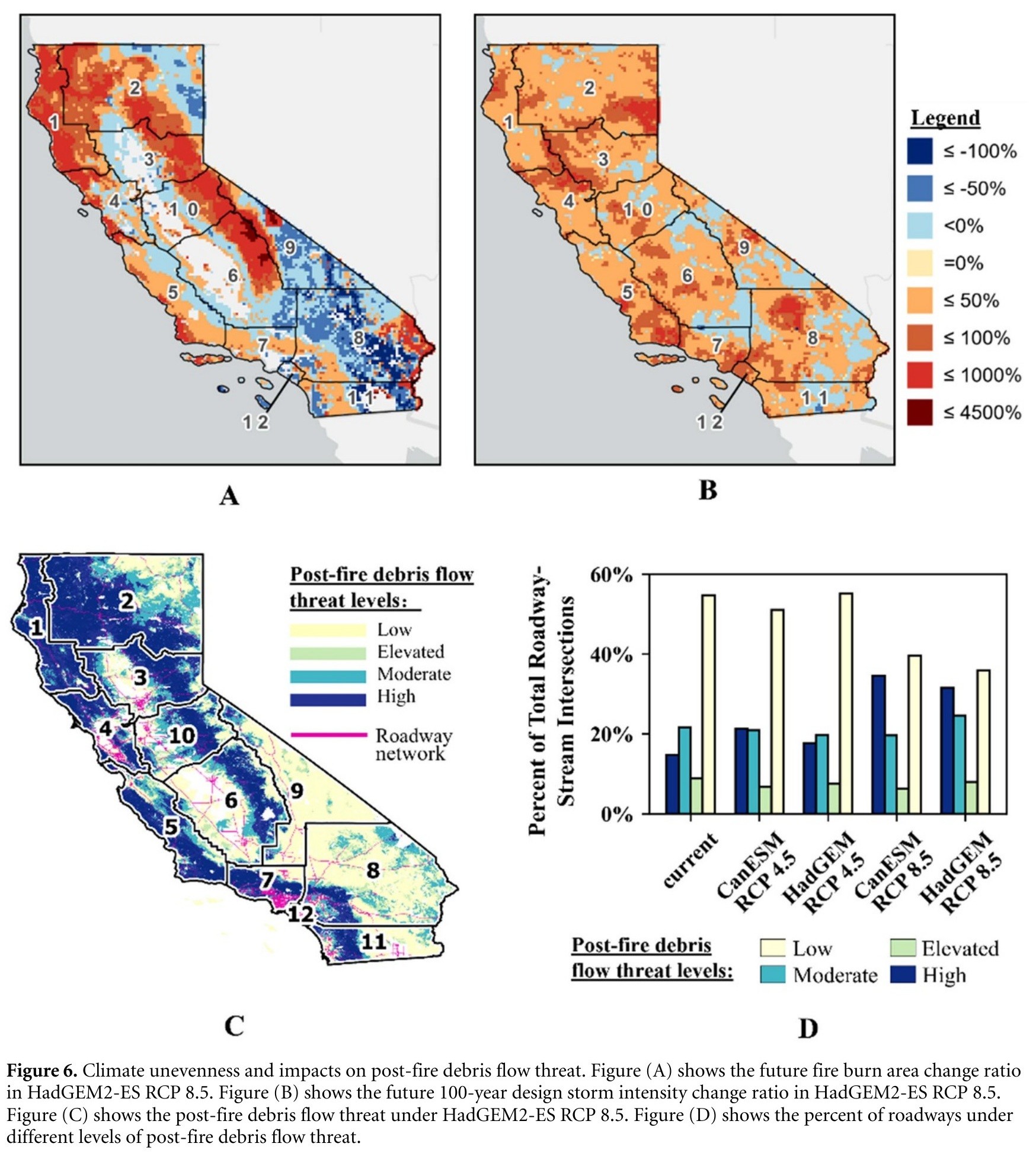
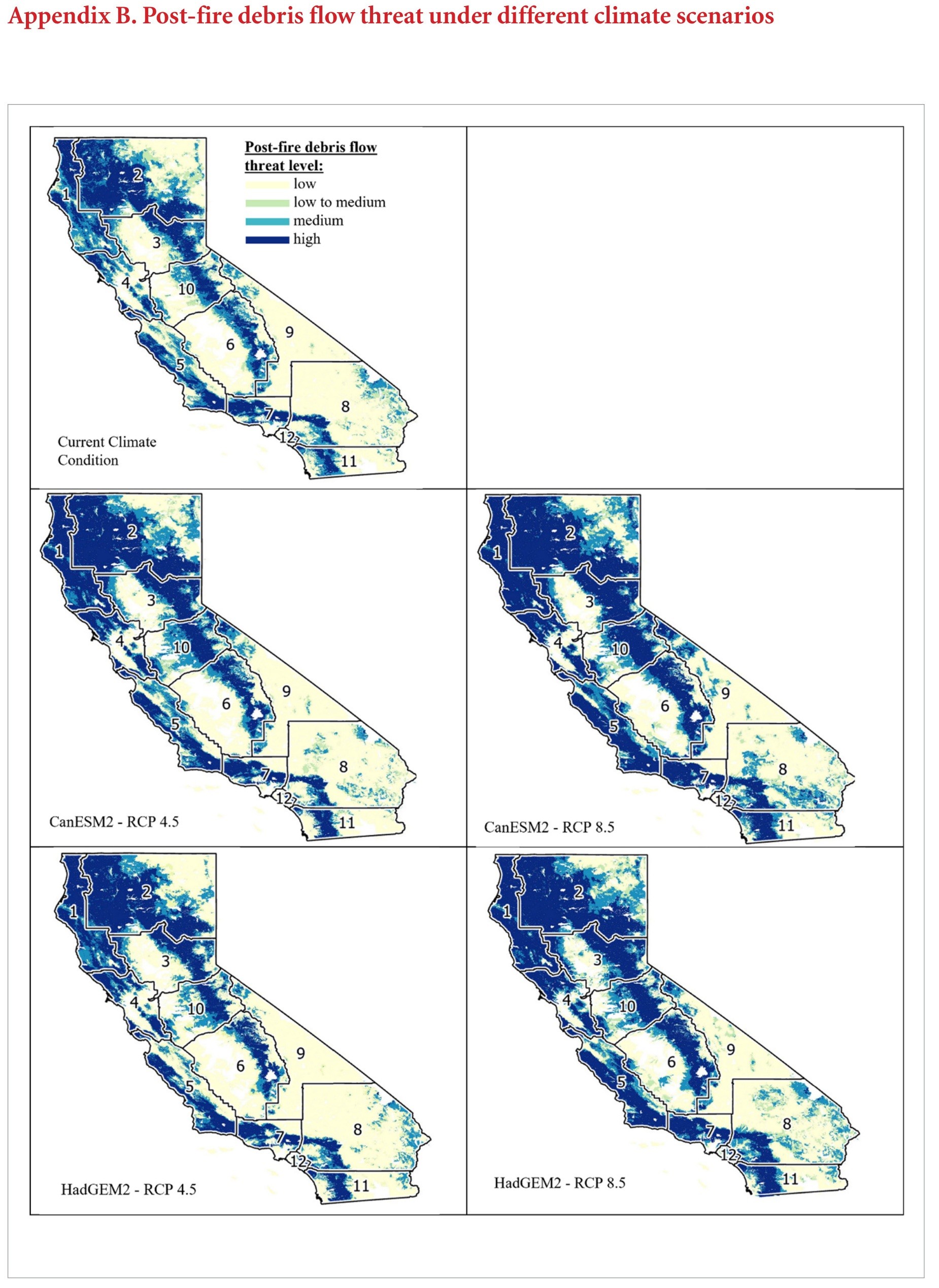
Vulnerability Of California Roadways To Post-Wildfire Debris Flows
--
https://doi.org/10.1088/2634-4505/acb3f5 <-- shared paper
--
#GIS #spatial #mapping #California #geology #engineeringgeology #geomorphology #risk #hazard #water #hydrology #massmovement #landslide #debrisflow #roadway #road #highway #CalTrans #infrastructure #cost #damage #economics #fire #wildfire #postwildfire #transportation #watersheds #climatechange #extremeweather #rainfall #precipitation #naturalhazards #vegetation #spatialanalysis #vulnerability #assessment #soil
#debrisFlow

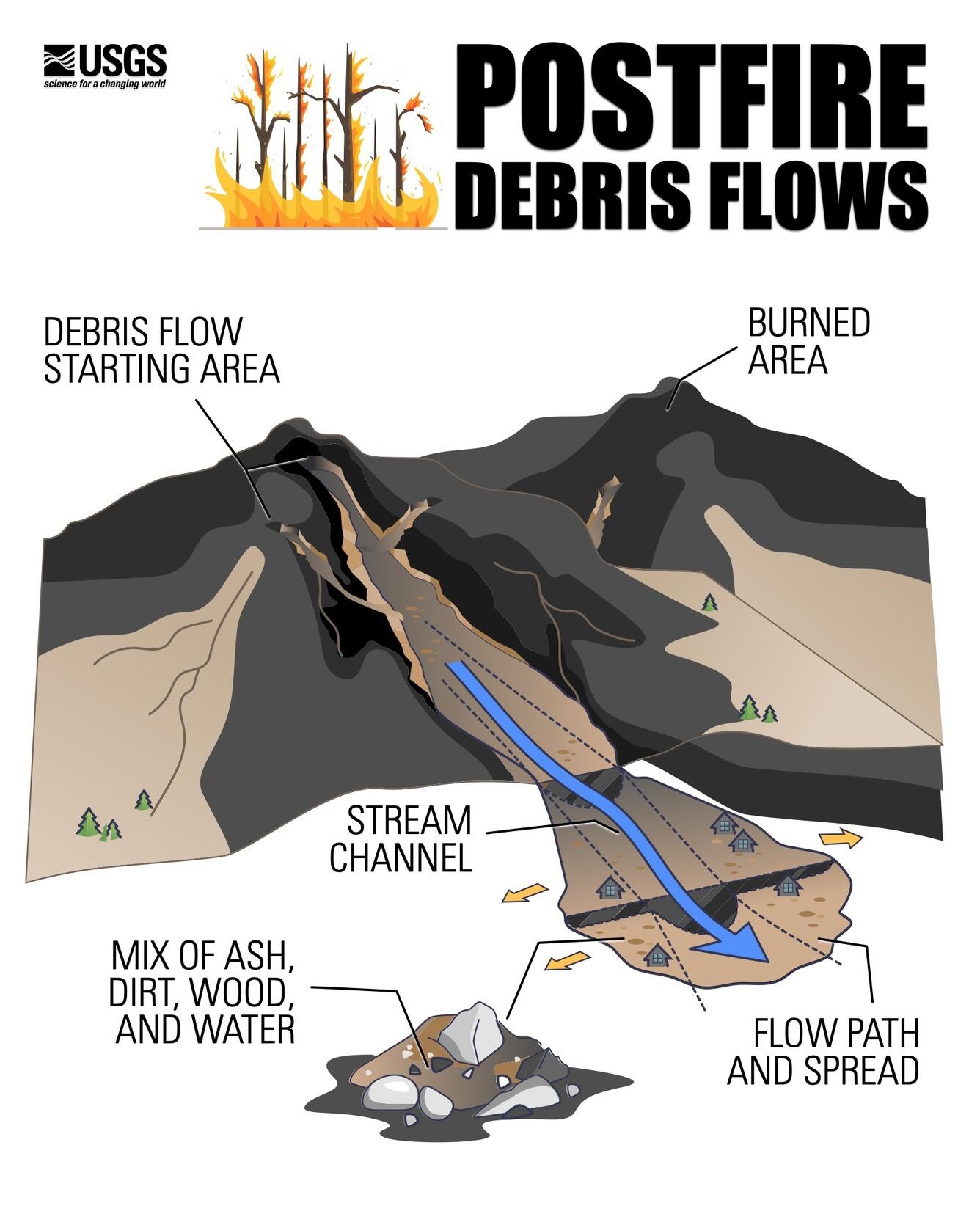
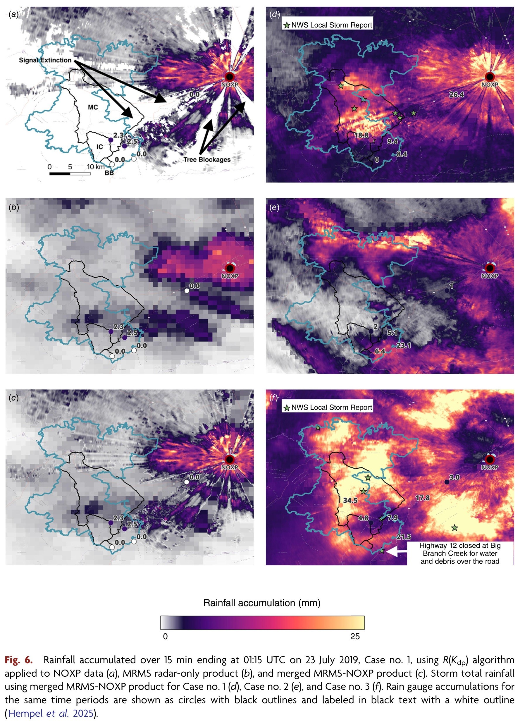
Mobile Radar Provides Insights Into Hydrologic Responses In Burn Areas
--
https://doi.org/10.1071/WF24163 <-- shared paper
--
#GIS #spatial #mapping #remotesensing #radar #water #hydrology #engineeringgeology #risk #hazard #massmovement #landslide #debrisflow #mobileobservatory #postfire #rainfall #precipitation #estimation #RockyMountains #streamradar #weatherradar #extremeweather # metrology #wildfire #fire #impacts #monitoring #hydrometeorological #instrumentation #burnarea #burnt #soil #basin #runoff #spatialanalysis #spatiotemporal #remoteareas #planning #management #mitigation

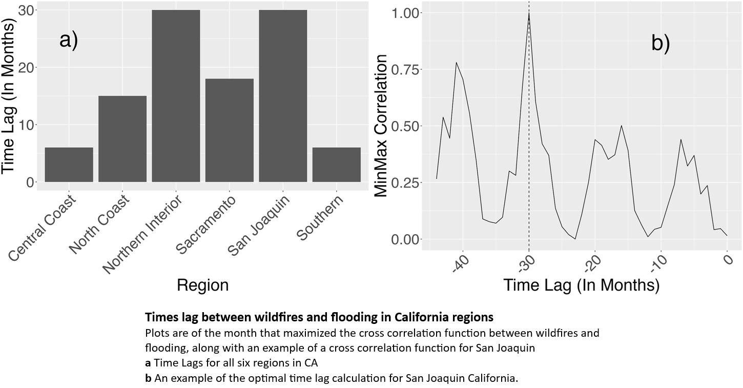
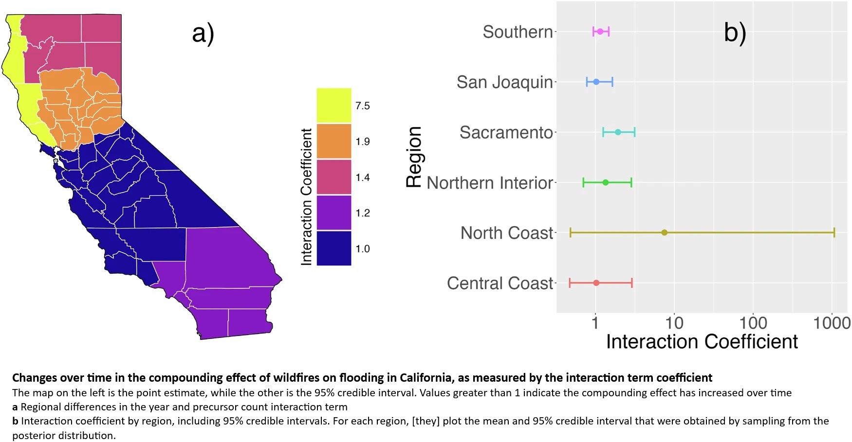
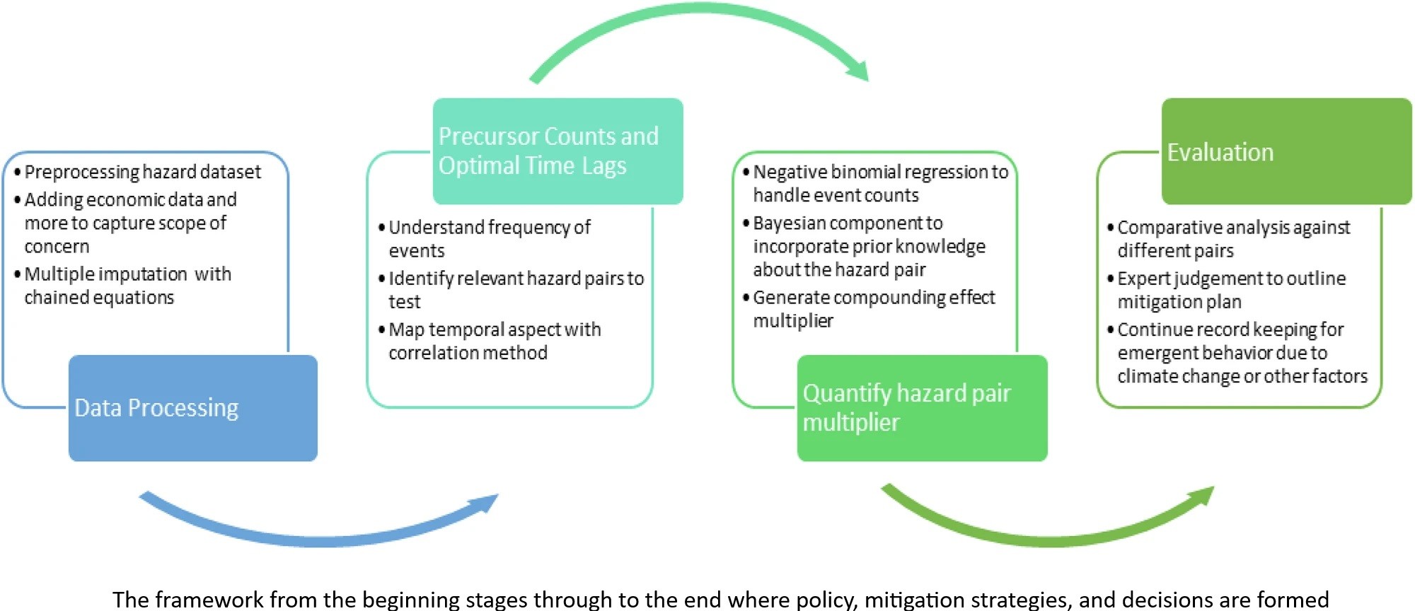
Quantifying The Compounding Effects Of Natural Hazard Events - A Case Study On Wildfires And Floods In California
--
https://doi.org/10.1038/s44304-025-00090-7 <-- shared paper
--
#GIS #spatial #mapping #spatialanalysis #spatiotemporal #casestudy #California #wildfire #fire #flood #flooding #climatechange #weather #extremeweather #risk #hazard #debrisflow #massmovement #impacts #damage #infrastructure #cost #economics #quantification #compoundinghazards #compound #compounding #framework #naturalhazard #naturaldisaster #recovery #temporal #regional #planning #policy #management #mitigation #geology #soils #engineeringgeology #geomorphology #resilience #preparation
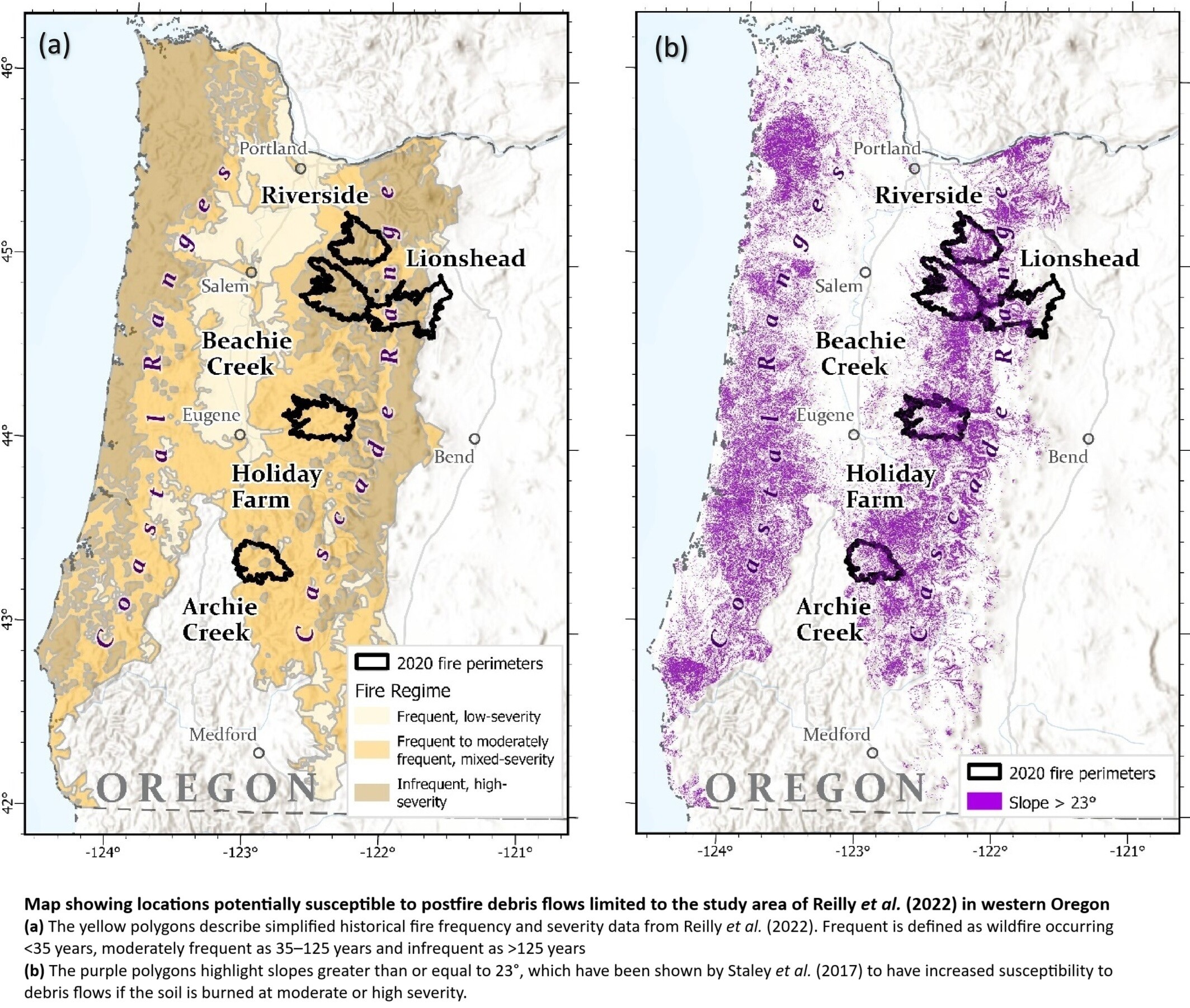
Assessment Of Western Oregon Debris-Flow Hazards In Burned And Unburned Environments
--
https://doi.org/10.1002/esp.70045 <-- shared paper
--
[with more and more catastrophic wildfires, the engineering geology awareness and possible mapping of post-fire debris flow risk is important]
#GIS #spatial #mapping #wildfire #fire #oregon #risk #hazard #geology #geomorphology #risk #hazard #landslide #massmovement #landslide #postfire #soil #spatialanalysis #spatiotemporal #engineeringgeology #extremeweather #naturaldisaster #debrisflow #mechasisms #property #infrastrure #publicsafety #lossoflife #model #modeling #calibration #water #hydrology #inventory #hazardassessment #geomorphometry


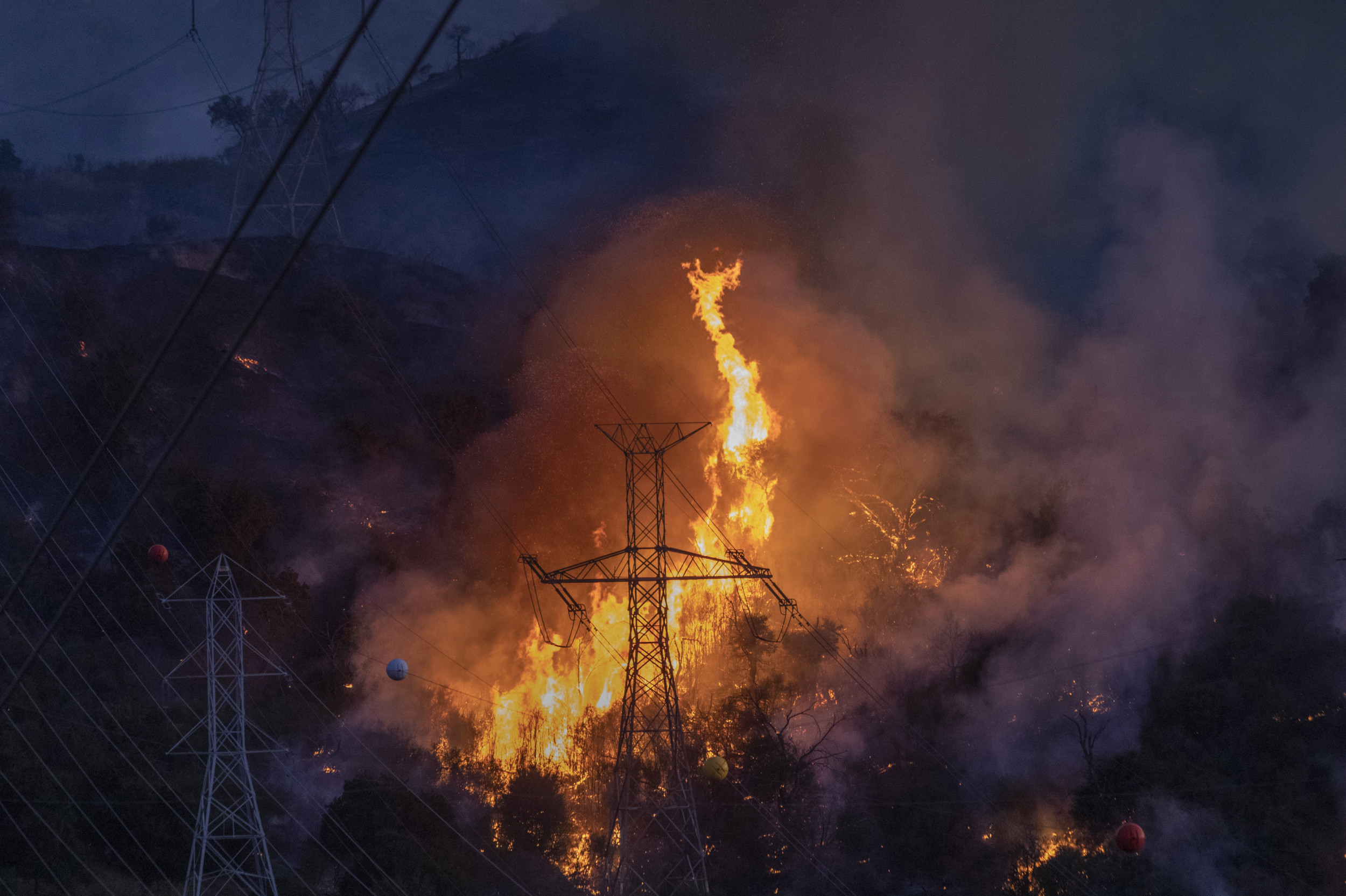
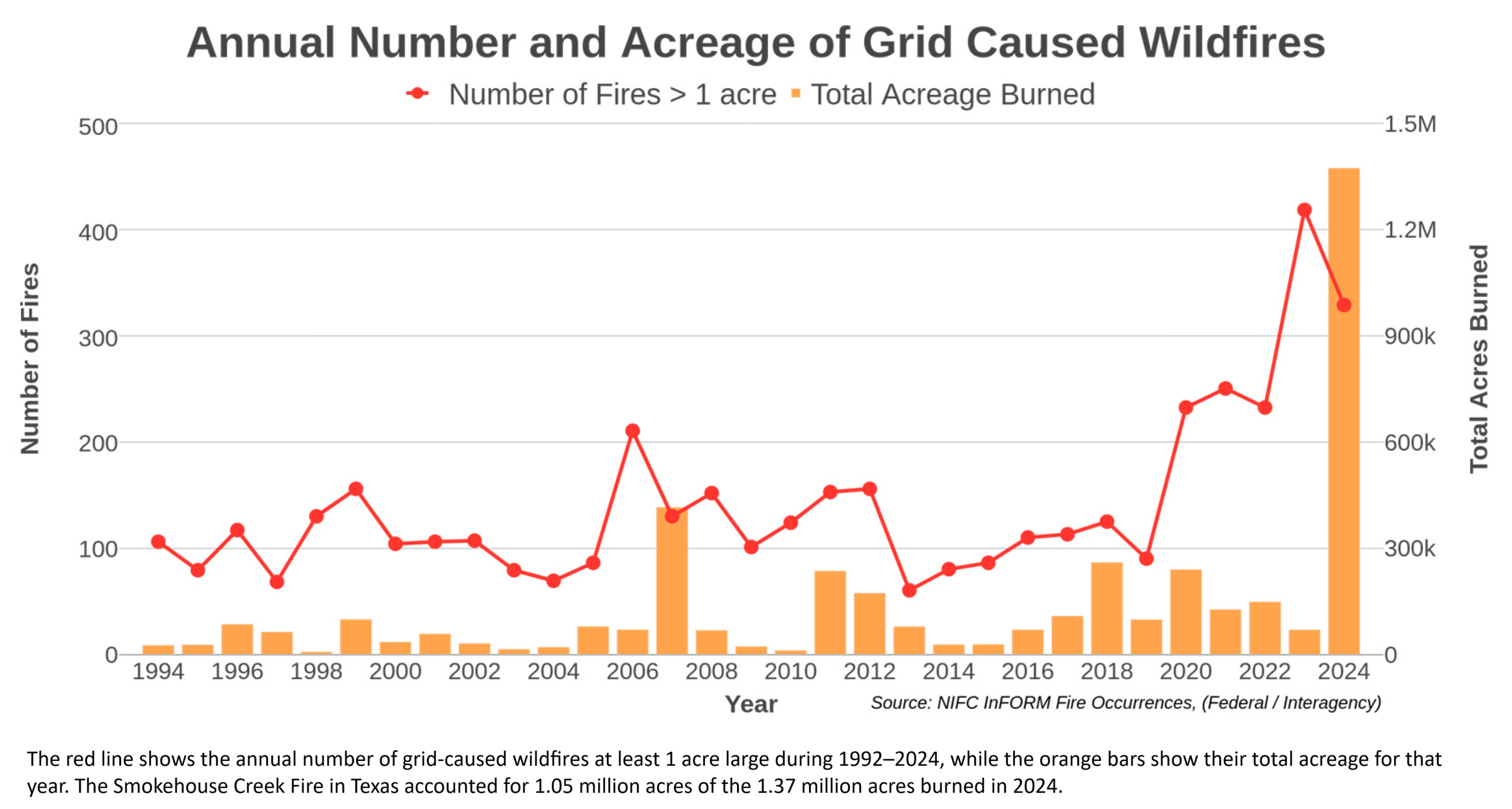
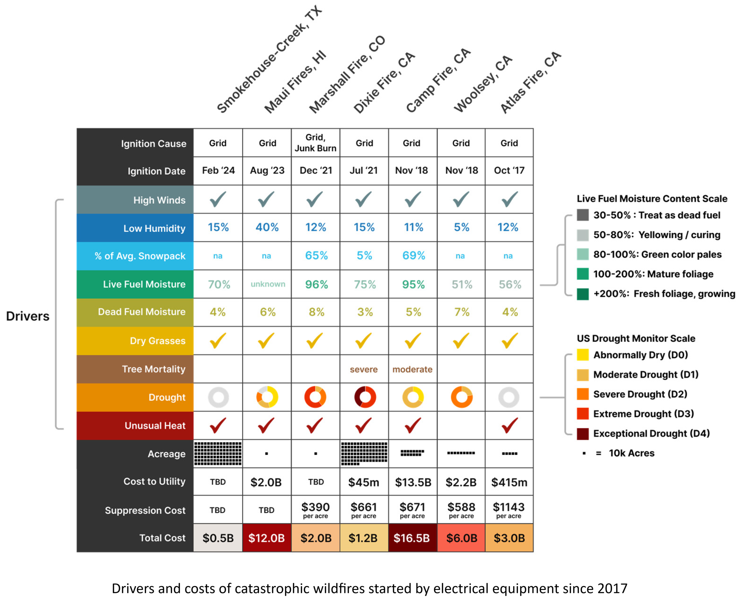
Systemic Drivers of Electric-Grid-Caused Catastrophic Wildfires - Implications for Resilience in the United States
--
https://doi.org/10.3390/challe16010013 <-- shared paper
--
#wildfire #electricgrid #ignitioncauses #wildfireprevention #mapping #spatial #spatialanalysis #risk #hazard #fire #wildfire #climatechange #Anthropocene #humanimpacts #infrastructure #massmovement #debrisflow #engineeringgeology #denudation #environment #ecosystems #ecology #loss #cost #economics #residential #waterquality #water #hydrology #electricty #energy #LahainaFire #CampFire #MarshallFire #SmokehouseCreek #fires #bushfire #vegetation #wind #weather #landuse #humanimpacts #utilitycompanies #utilities #resiliency
LAFD has info and maps for the various #Evacuation warnings they've issued for the coming rains and #DebrisFlow risks.
They've sent deputies into the field because while there are warnings for general areas, specific addresses will have mandatory evacuation orders. This is pretty smart really, and deputies can inform non-ordered addresses of risks, so educational.
https://lafd.org/news/evacuation-warnings-march-1213-due-high-mudslidedebris-flow-risk
Due to the forecasted high rains which have the potential to trigger mudslides and debris flows on March 12-13, the City of Los Angeles is issuing EVACUATION WARNINGS for several areas and limited, address specific Evacuation Orders which will go into effect from 7AM Wednesday (3/12/2025) to 6pm Thursday (3/13/2025)
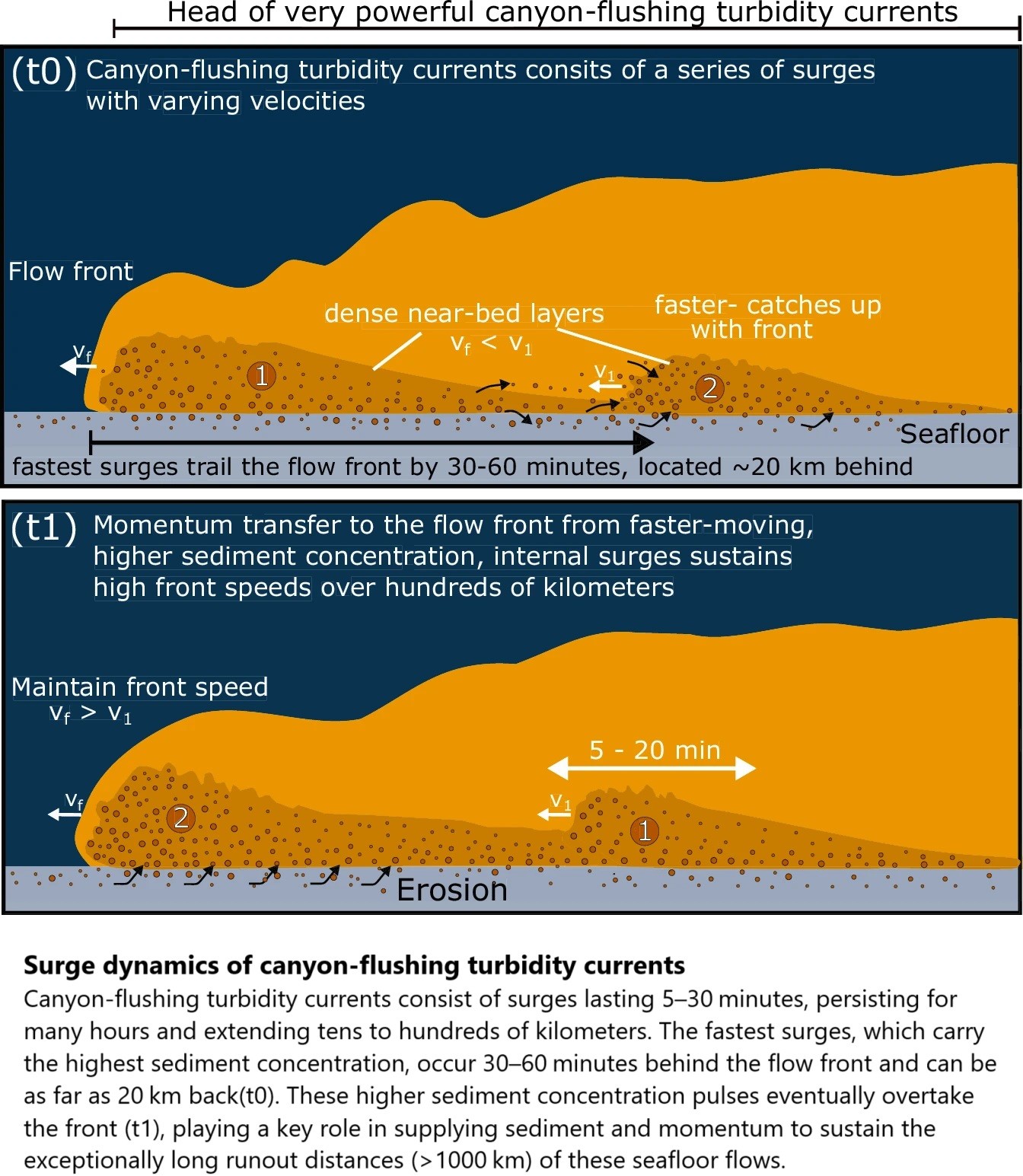
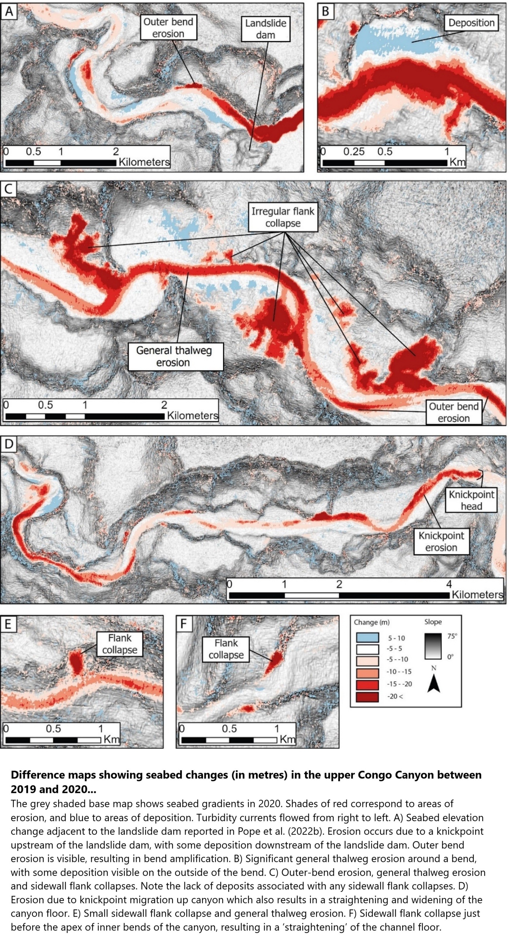
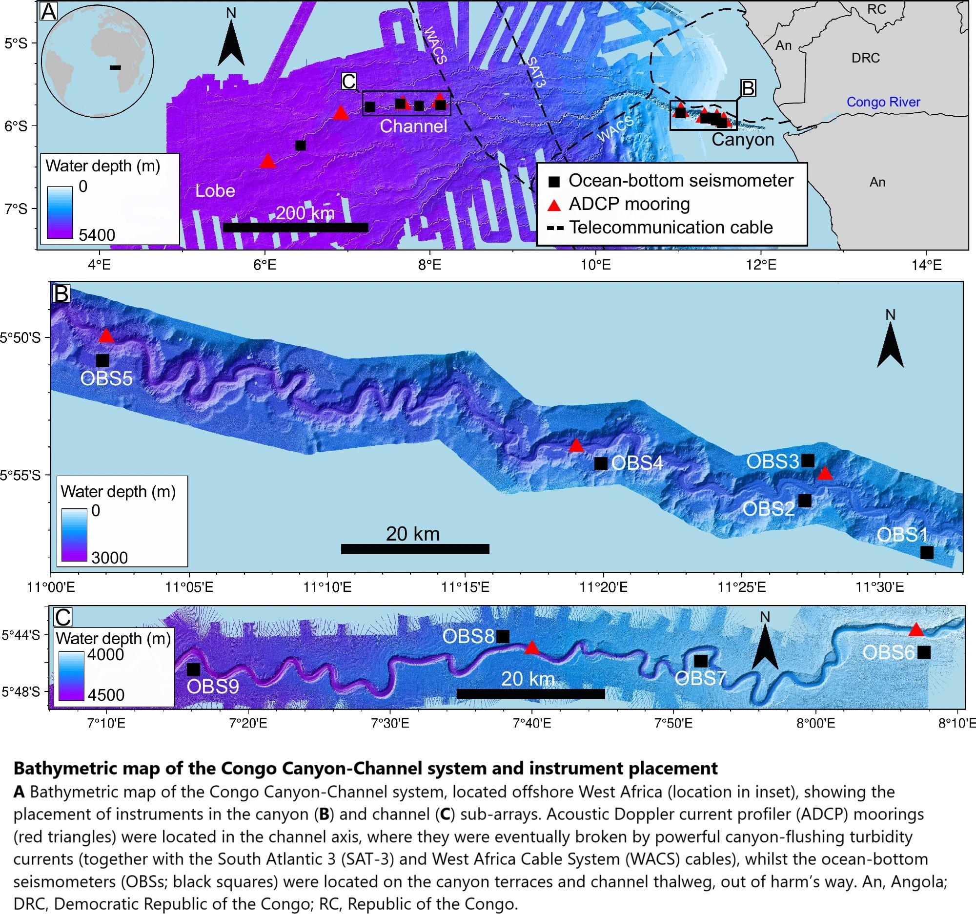
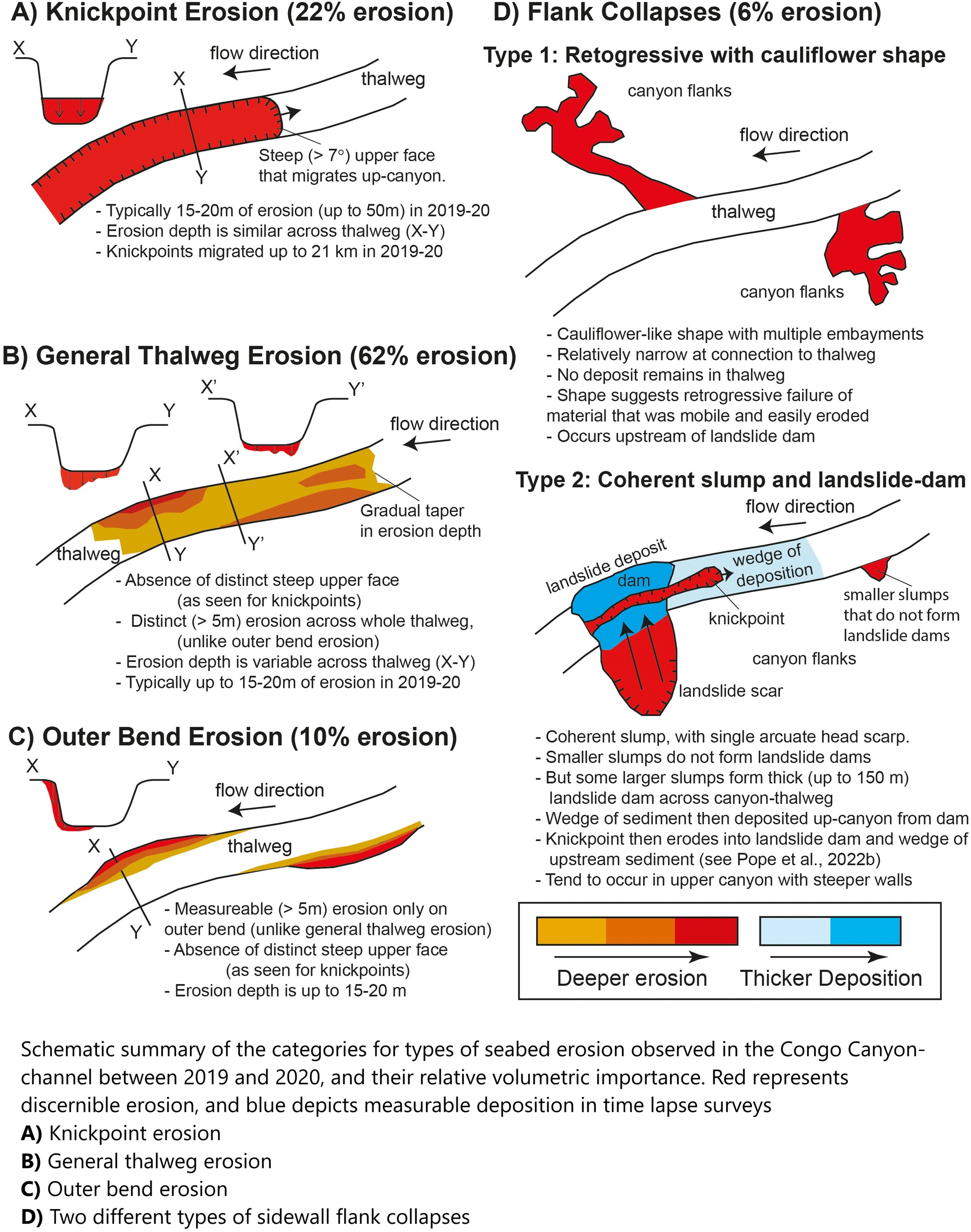
Seismometers Reveal Earth's Longest-Runout Undersea Sediment Flows In Unprecedented Detail
--
https://phys.org/news/2025-02-seismometers-reveal-earth-longest-runout.html <-- shared technical article
--
https://doi.org/10.1038/s43247-025-02137-z <-- shared paper
--
https://doi.org/10.1016/j.geomorph.2024.109350 <-- shared paper
--
https://doi.org/10.1038/s41561-022-01017-x <-- shared paper
--
#GIS #spatial #mapping #remotesensing #Congo #CongoChannel #bathymetry #seismometers #monitoring #sediment #flow #submarine #massmovement #canyon #infrastructure #pipes #cables #engineeringgeology #geology #model #current #debrisflow #bathymetric #Africa #offshore #coast #coastal #river #WestAfrica #instrumentation #acoustic #doppler #moorings #turbidity #thalweg #morphology #landslides #stratigraphy #seismic #turbiditycurrent #flow #gradient #slope #erosion #risk #hazard #spatialanalysis #spatiotemporal #seabed
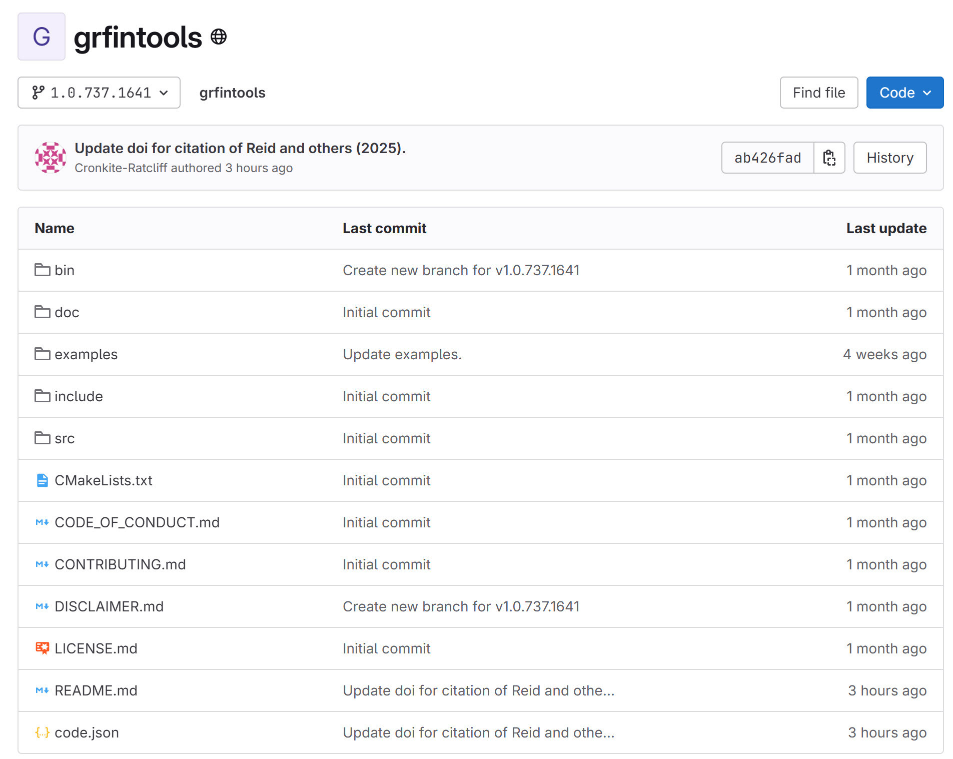
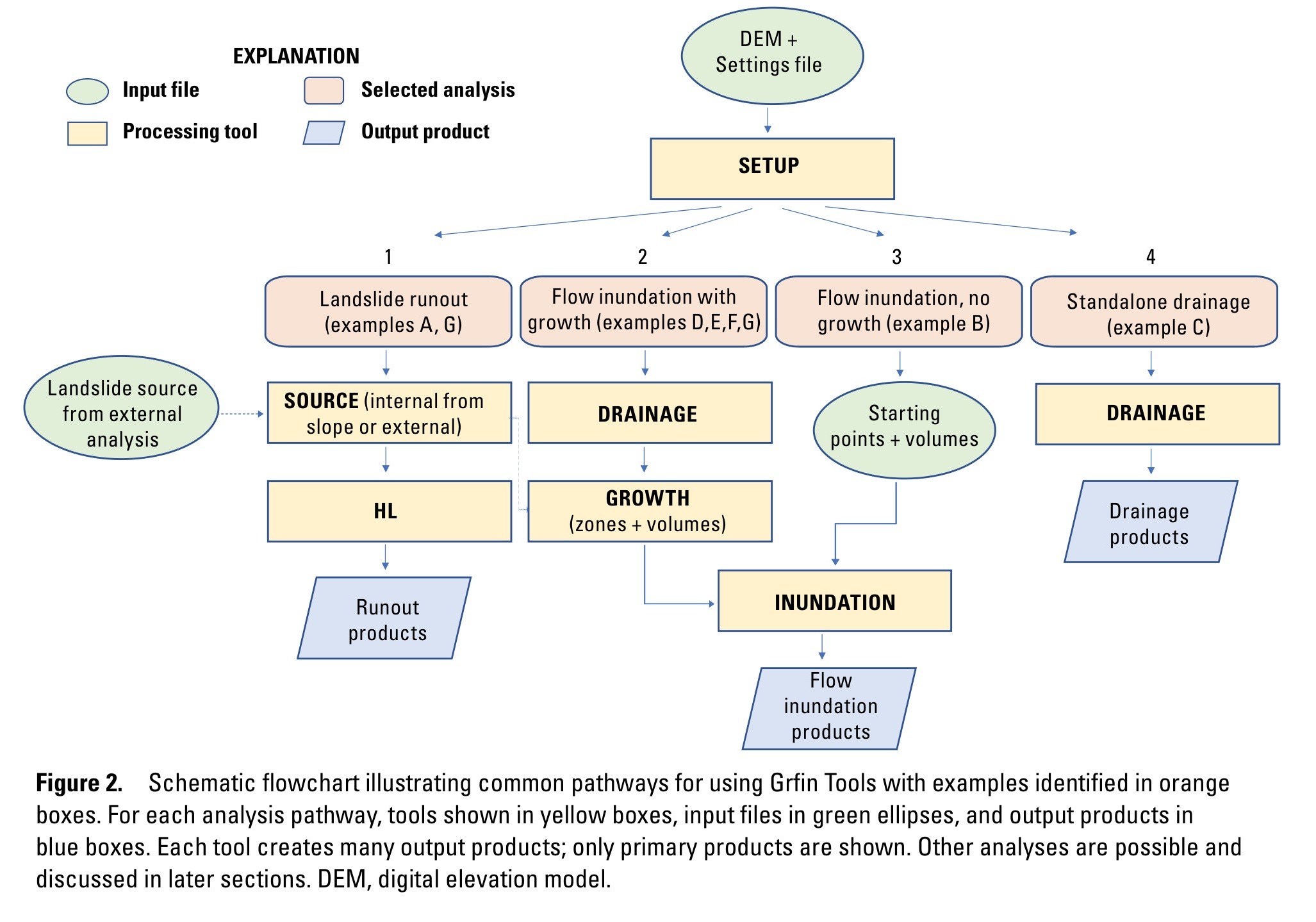
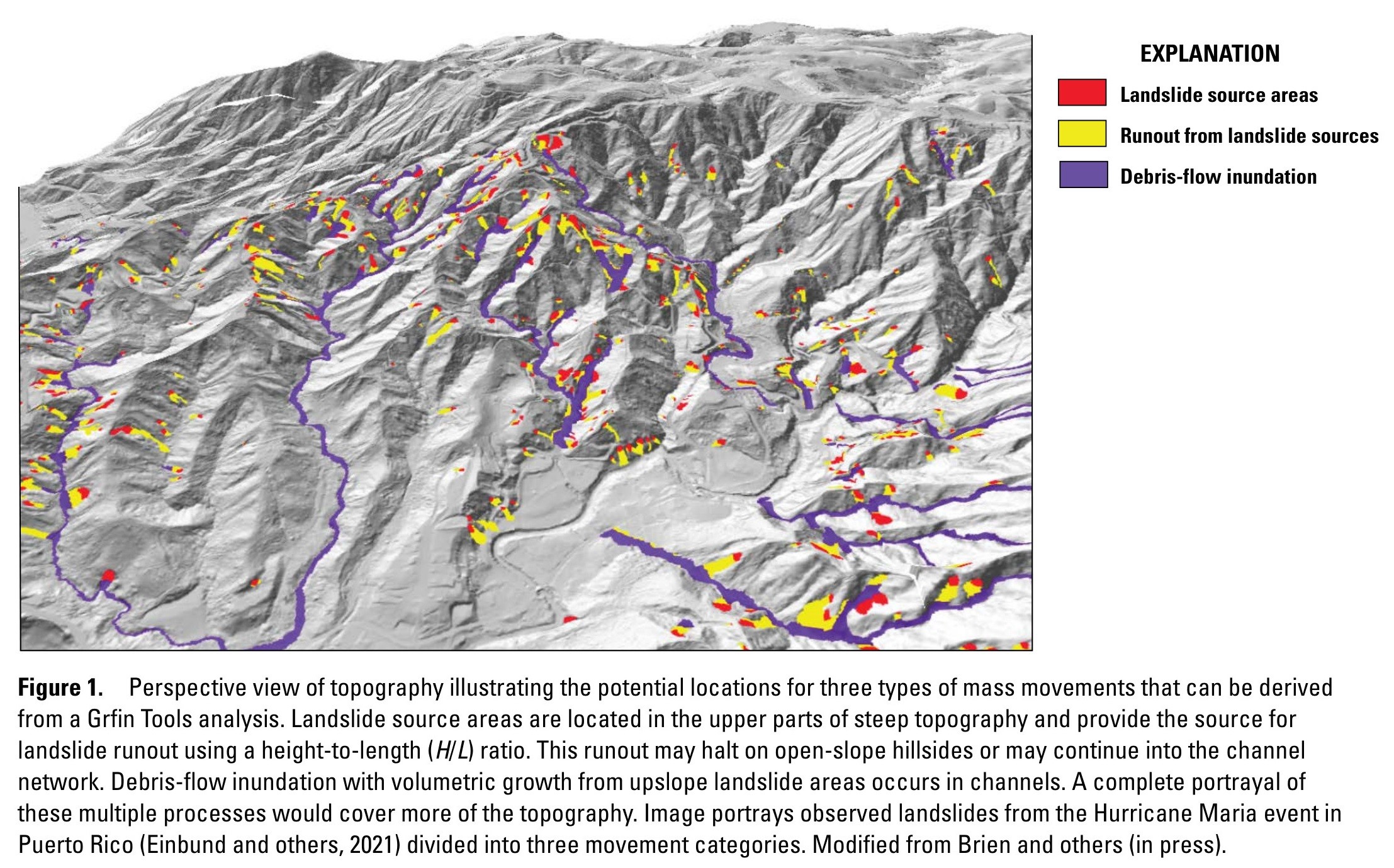
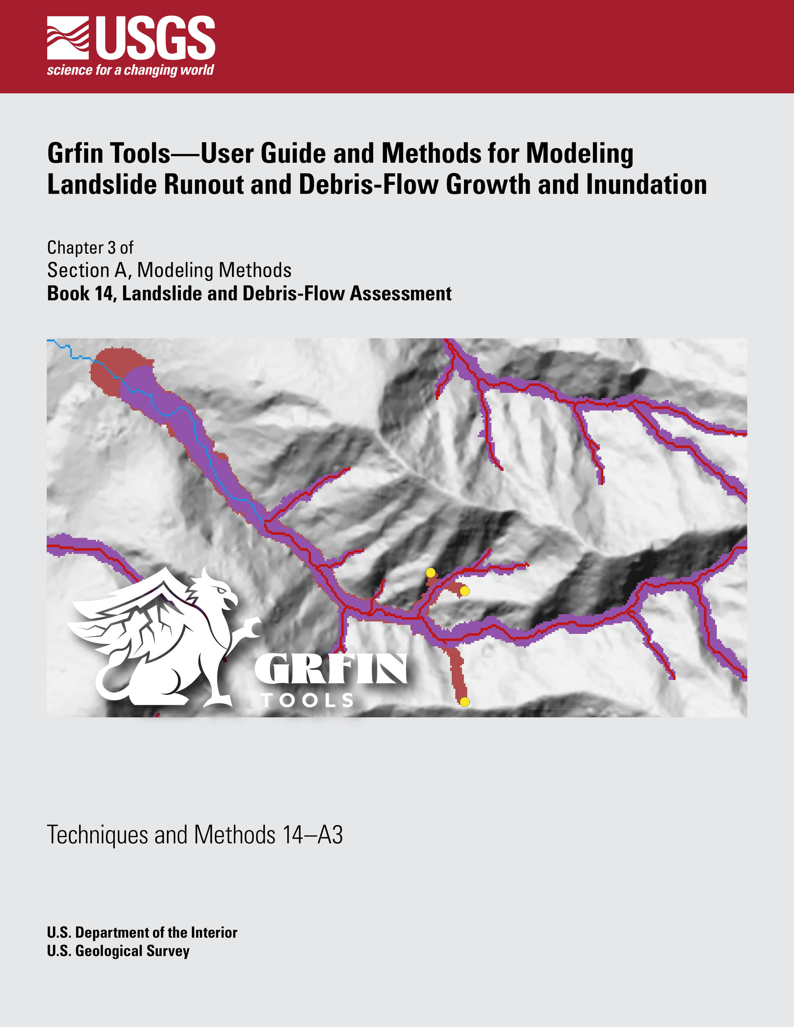
Grfin Tools—User Guide And Methods For Modeling Landslide Runout And Debris-Flow Growth And Inundation
--
https://pubs.usgs.gov/publication/tm14A3 <-- shared USGS publication
--
https://code.usgs.gov/grfintools/grfintools <-- shared USGS software release
--
H/T Jonathan Perkins USGS
[ another open source resource for everyone from the USGS ~smile~ ]
#GIS #spatial #mapping #opensource #openlibrary #Grfin #software #package #regional #debrisflow #engineeringgeology #geology #inundation #spatialanalysis #spatiotemporal #geophysics #geophysical #massmovement #landslide #lahar #volcano #rock #avalanche #model #modeling #statistical #geostatistics #water #hydrology #downstream #elevation #remotesensing #DEM #flow #runout #risk #hazard #tools #slope #erosion #drainage #network #channel #channelisation #userguide
@USGS
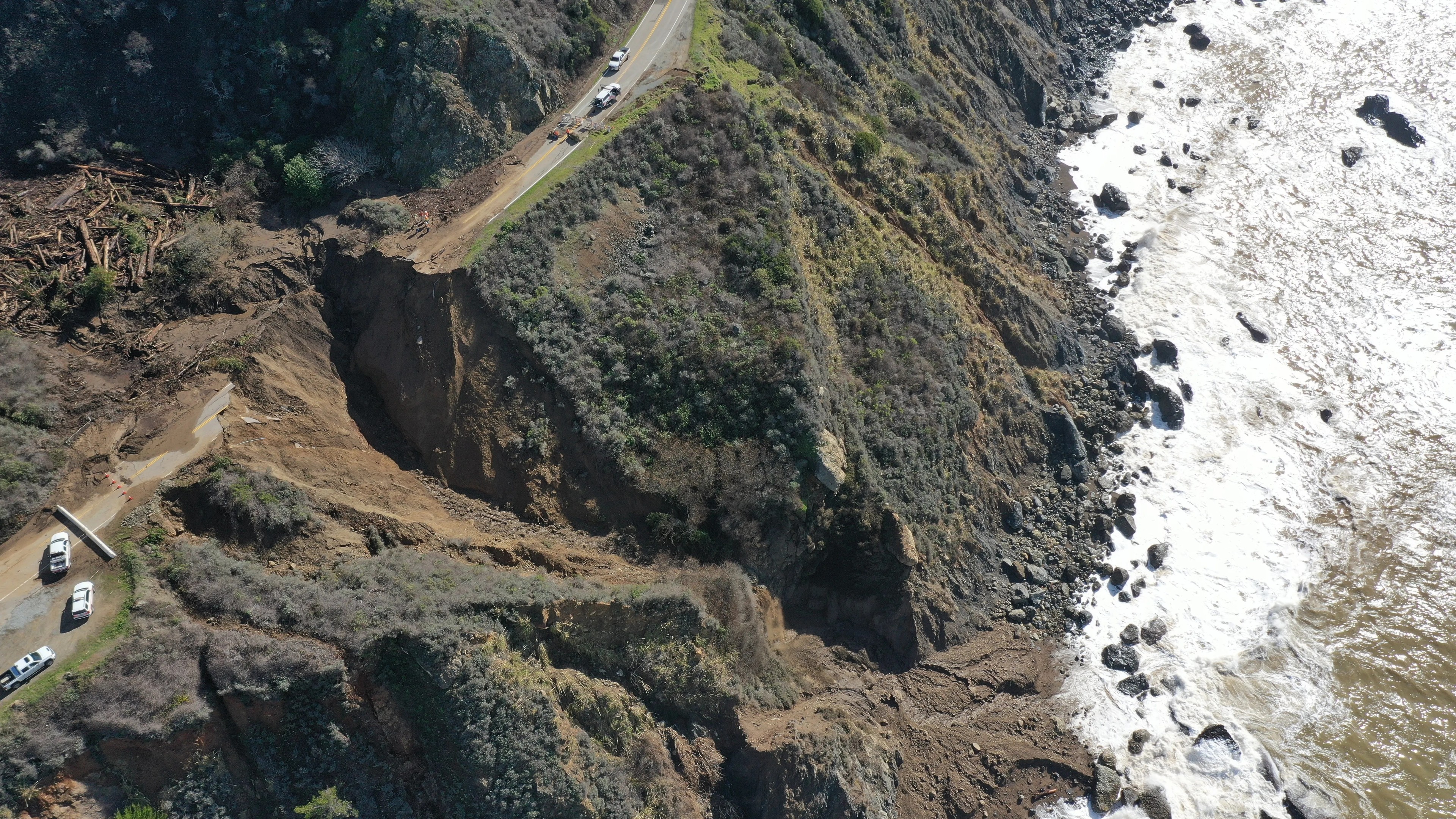
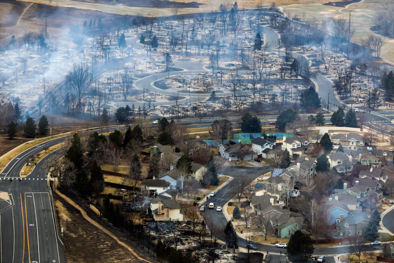
Cities turn into torrents of debris flows after bushfires and rain
All that is solid melts into air...
>>
https://www.sciencenews.org/article/danger-after-la-fires-debris-flows
#FossilFuels #petrotopia #climate #infrastructure #fires #erosion #soil #sprawl #DebrisFlow
Flash Flood Warning issued February 13 at 5:30PM PST until February 13 at 8:00PM PST by NWS Los Angeles/Oxnard CA
At 530 PM PST, local law enforcement reported dangerous debris flows in Altadena as a result of extremely heavy rainfall that is moving over the area. THIS IS A VERY DANGEROUS SITUATION!
HAZARD...Life threatening debris flows in and around the Eaton
Burn Scar.
SOURCE...Law enforcement reported.
IMPACT...Mud, rock, and debris flows are impacting drainages,
roads, and residences in and directly below the burn
area.
Info on #DebrisFlow cameras. Snipped from FB. #AtmosphericRiver #CAwx
"Update: all seven new cameras are now online
With a major atmospheric river projected to hit Southern California this week, ALERTCalifornia's field team has been working hard to install seven new cameras around Los Angeles to help emergency managers monitor potential debris flows from the Eaton and Palisades burn scars. The Bailey Canyon 1 & 2, Sierra Madre Canyon 1 & 2, and Sierra Madre Bridge cameras are already online for the the Eaton Fire scar. Cloudcroft 1 & 2 cameras will be online soon for the Palisades Fire scar. Search camera names at cameras.alertcalifornia.org to see their locations."
AlertLACounty: Emergency message from LASD: 02/12/25 6:10pm: Deputies are in the field notifying residents of local mud/debris flow risk from PALISADES AND FRANKLIN FIRE burn scars. PARTS OF MALIBU, TOPANGA AND ALL OF SUNSET MESA are under EVACUATION WARNING until at least 2/14/25 2pm due to risk to of losing access. PREPARE NOW. More info at alertla.org. #wildfires #PalisadesFire #FranklinFire #flooding #debrisflow #warning
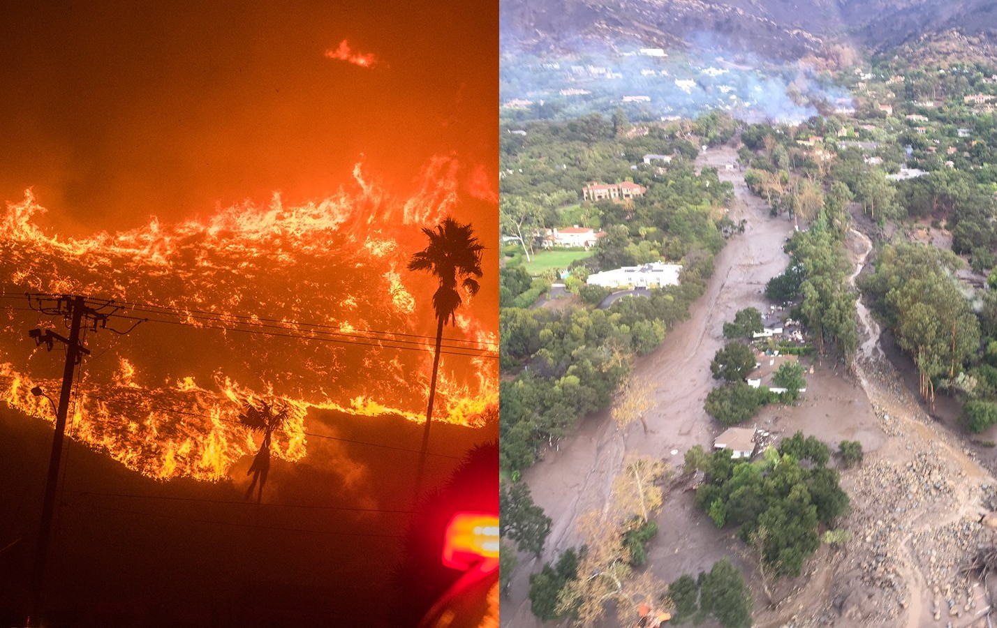
@exador23 @ai6yr One thing that was learned from the 2018 Montecito #DebrisFlow was that at bends in the channel the material sometimes tends to pile up and then overshoot the bank on the downward side. The debris flow then continues *outside* the channel by finding a new path of least resistance which could very well be right down streets, through yards, etc.
When this map opens it is centered on the #EatonFire area and shows the drainage ways with a black dot at the low end of each one. The map also shows the weather radar with yellow areas indicating heavier rain than green areas.
There is concern that heavy rains may cause #DebrisFlow
You can drag the map over to the area of the #PalisadesFire and see the same thing.
#AtmosphericRiver #CAwx
The colors on this map always show an estimate from NOAA of the rainfall expected over the next 5 days. As is typical, south facing slopes are expected to receive increased rain.
The map also shows pink shading for recent fire perimeters including for the #EatonFire and #PalisadesFire where there is at least some #DebrisFlow risk.
#AtmosphericRiver #CAwx
#California #AtmosphericRiver #DebrisFlow
From Los Angeles Times: Powerful new rainstorm brings risk of debris flows to L.A. fire zones this week
#DebrisFlow possible for #EatonFire and #PalisadesFire
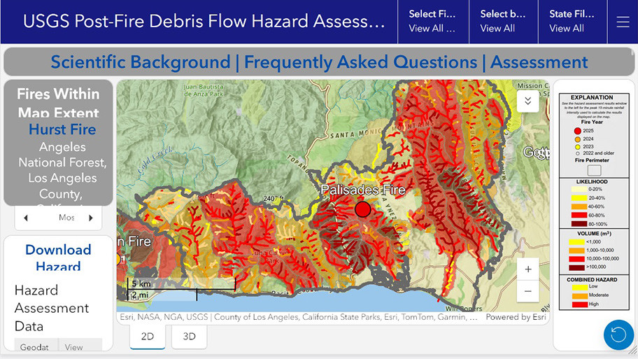
Open interactive map with lots of links for more information. It will automatically zoom in on the Eaton fire. You can pan the map to the Palisades fire.
https://usgs.maps.arcgis.com/apps/dashboards/c09fa874362e48a9afe79432f2efe6fe#fire_id=eat2025

Client Info
Server: https://mastodon.social
Version: 2025.04
Repository: https://github.com/cyevgeniy/lmst