
Where the rising river met the bank in Launceston.
Launceston, Tasmania, Australia.
© 𝓐𝓵𝓵 𝓡𝓲𝓰𝓱𝓽𝓼 𝓡𝓮𝓼𝓮𝓻𝓿𝓮𝓭 𝓫𝔂 𝓚𝓮𝓿 𝓟𝓮𝓲𝓻𝓬𝓮.
#photo #photography #australia #tasmania #TamarRiver #OvercastSky #Launceston #FloodPlain
#floodplain


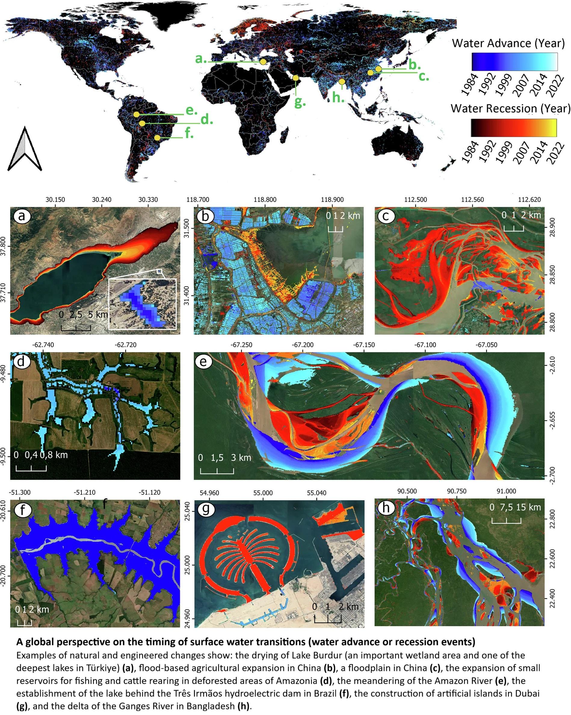
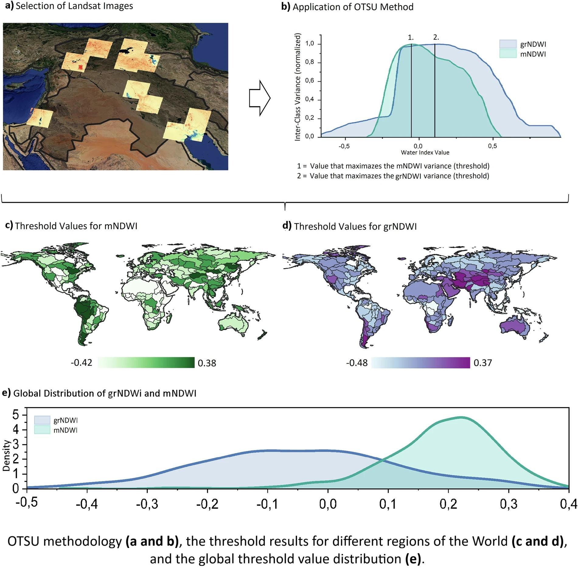
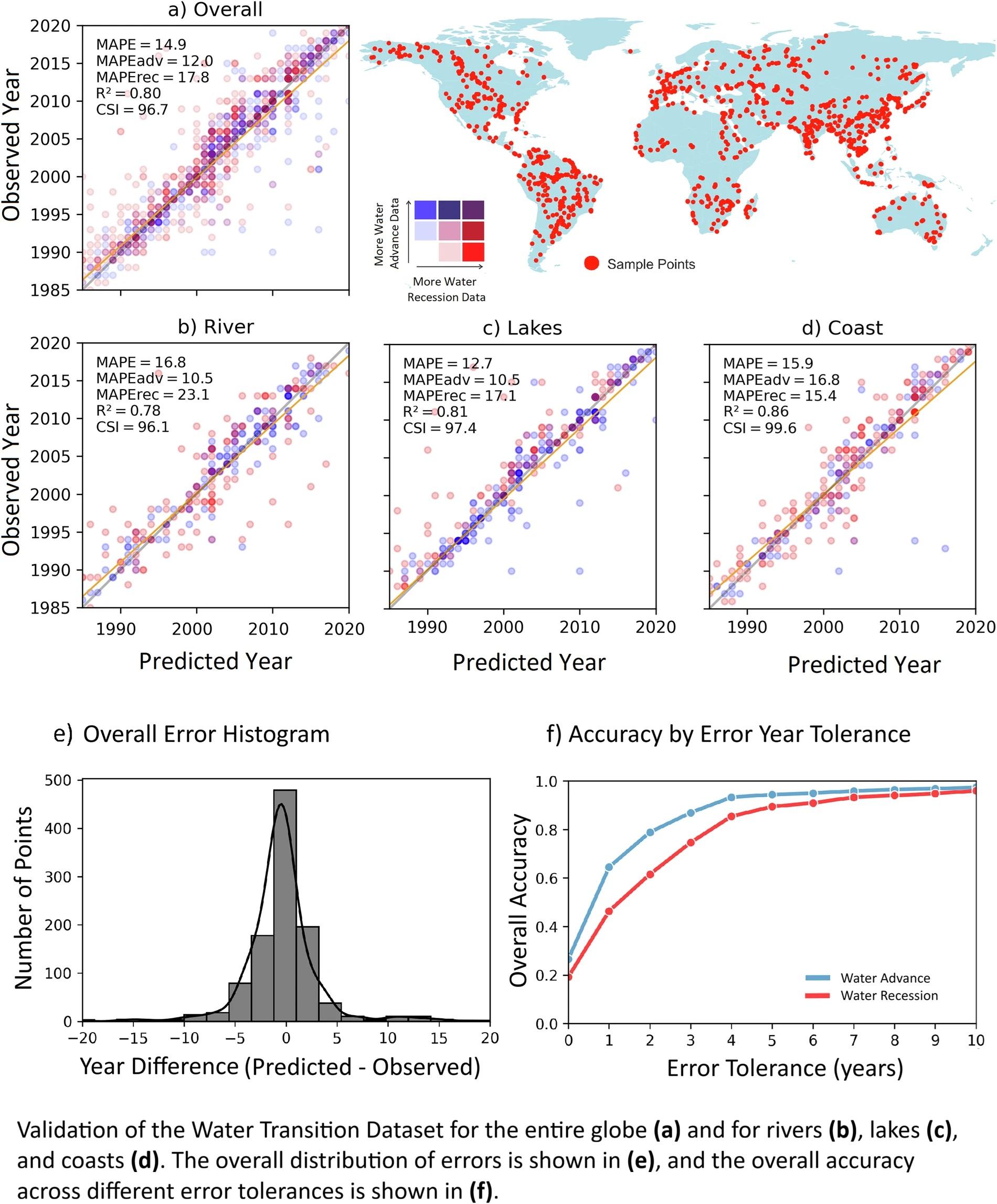
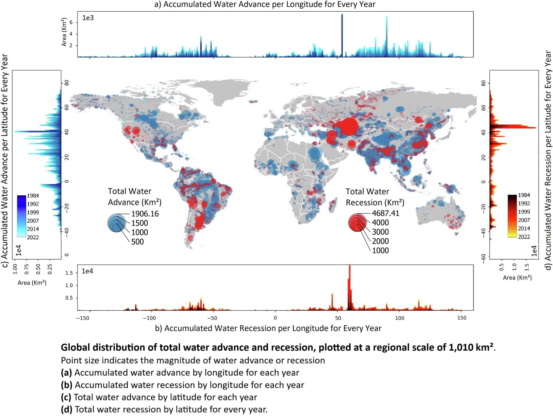
Surface Water Transitions 1984–2022 - A Global Dataset at Annual Resolution
--
https://doi.org/10.1038/s41597-025-06013-5 <-- shared paper
--
#water #hydrology #hydrospatial #globe #global #remotesensing #spatialanalysis #spatiotemporal #GIS #spatial #mapping #watertransition #river #stream #lake #coast #coastal #landsat #timeseries #WCD #WTTD #OTSU #NDWI #landuse #landcover #NLDI #soil #vegetation #forest #urban #industrial #advance #recession #wetland #engineered #agriculture #floodplain #deforestration #reservior #delta #model #modeling #surfacewater #change #seasonal #climate #annual #historic #recenthistory #waterresources #watermanagement #watersecurity
Diversion Channels vs. Climate Change: Will Five Cities’ Flood Protection Strategy Be Enough?
Many of those reading this post may recall scenes from the disastrous floods that took place along the Red River of the North in 1997, 2009, and 2011. Cities like Fargo and Grand Forks, North Dakota were severely impacted by floodwaters due to snowmelt and ice jams along that northward flowing river. Further north along the same river, in Manitoba, Winnipeg has dealt with significant flooding on multiple occasions.
Fargo flooding in 2011 – Source: wsj.comPart of the problem along this particular river valley is there is very little topographical change in this area, so when river levels run high, the floodwaters spread out far and wide across the northern prairie landscape. The limited grade change also tends to slow the speed of the river’s flow, which can add to the backup.
Tragic water and fire damage to downtown Grand Forks from 1997 flood – Source: grandforksherald.comTo address these costly and dangerous flooding problems along the Red River of the North, both Winnipeg and Grand Forks have developed enormous flood diversion channels around their urban area. Meanwhile, Fargo is close to completing its diversion channel. These three diversion systems are discussed below followed by other diversion channel programs established in Wichita, Kansas and Albuquerque, New Mexico.
Red River Floodway – Winnipeg, Manitoba, Canada = 29 mile diversion channel
- Completed in 1968 for $63 million and enlargement completed in 2010 for $665 million
- Designated a National Historic Site in 2000
- Capacity of 140,000 cubic feet per second
- 2.7 billion cubic feet of Earth moved (more than the Suez Canal)
——-
English Coulee Diversion Channel – Grand Forks, ND, USA = 13 mile diversion channel for English Coulee and 8 miles of flood walls/levees along the Red River of the North
- The diversion channel for English Coulee bypassing Grand Forks was completed in 1990. Unfortunately, increasing the height of flood walls and levees was not completed until 2007.
- Total project cost was $409 million including the flood walls and levees on the Red River of the North.
- Flood protection was raised from 50 feet to 60 feet.
- Flood/stormwaters can be also pumped to the diversion channel from the city — up to 112,000 gallons per minute (= 250 cubic feet per second).
- Twenty miles of greenways trails
——-
Fargo-Moorhead Area Diversion Project – Fargo, ND/Moorhead, MN, USA = 30 mile diversion channel and 22 mile earthen embankment at the southern end of the complex
- To be completed in 2027 for $3.2 billion
- The Red River has reached flood stage in Fargo 60 times since 1902, including every single year between 1993 and 2011.
- Designed to withstand a 100-year flood and provide fightable protection against a 500-year flood.
- Capacity of 20,000 cubic feet per second.
- Other features will include levees, flood walls, stormwater lift stations, road improvements including raising grades, upstream mitigation, wetland mitigation, river restoration, a bike/walking trail, and related flood control projects in outer communities and in nearby Minnesota.
——-
Further to the south, Wichita, Kansas has faced similar issues with flooding from the Arkansas and Little Arkansas Rivers. To limit future damage to life and property in the city, an enormous flood diversion project was completed here in 1959. This diversion channel is very visible to drivers along Interstate 235 around the west side of the city.
Wichita-Valley Center Floodway – Wichita, KS, USA = 18 mile diversion channel
- Completed in 1959 for $20 million
- Includes 50 miles of connecting channels, 100 miles of levees, and 150 control structures.
- The diversion channel has a flood carrying capacity twice that of the Arkansas River itself, while the Little Arkansas River portion around the town of Valley Center has a capacity of 55,000 cubic feet per second.
——–
In an altogether different context, Albuquerque, New Mexico can also face quick and devastating floods, but not from a flat terrain. Instead, the threat here is threefold – rapid snowmelt from the abutting Sandia Mountains flowing down into the city and the valley combined with urban stormwater runoff and heavy summer monsoon-season rains (yes, we have a monsoon season here) overwhelming the natural arroyos and dry stream beds. In Albuquerque, a network of diversion channels has been developed, with two primary ones (the North and South Diversion Channels) being the largest collectors and distributors of stormwater and floodwaters from natural arroyos and human made/enhanced channels.
Monsoon season storm over Albuquerque – Source: flickr.comNorth Diversion Channel – Albuquerque, NM, USA = 8.7 miles
- Completed in 1969 at a cost of $20.3 million
- Capacity of 44,000 cubic feet per second ~ equivalent to a 500-year flood event
- Collects flood/storm waters from 50 square miles and discharges it into the Rio Grande
- A bicycle/pedestrian trail runs along the top of the channel for its entire length.
- Passes through the heart of the city instead of around it.
South Diversion Channel – Albuquerque, NM, USA ~ 5.5 miles
- Completed in 1972 at a cost of $8.3 million and discharges into the Rio Grande
- A bicycle/pedestrian trail runs along the top of the channel for much of its length.
——-
As these five examples show, there are viable options for protecting life, limb, and property from devastating floods in urban areas. That being said, as the Earth’s climate continues to become warmer, bringing with it heavier rainfalls and stronger storms, even these diversion channels and their associated infrastructure may become overwhelmed by future weather events.
Source: climateactiontracker.orgTherefore, addressing only the after-the-fact results of storms will not protect our communities as long as climate change is allowed to continue on its current trajectory. Humankind must also address the root causes of climate change, including the impacts we create by our individual and collective actions and activities. This includes making hard choices…frankly choices that highly-developed First World countries like the United States too often avoid making.
Furthermore, when nations ignore climate reality, these five cities, let alone many others across the planet, will need to upgrade their flood defenses over and over again. In this era of climate change, such efforts will not and cannot solve the problem alone. Humanity must find the “sustainable willpower” to effectively address climate change for the long term. In the end, future generations will be grateful that we did.
Peace!
#albuquerque #cities #climateChange #diversionChannels #environment #fargo #flooding #floodplain #floods #geography #grandForks #history #infrastructure #landUse #monsoonSeason #planning #rivers #stormwater #wichita #winnipeg


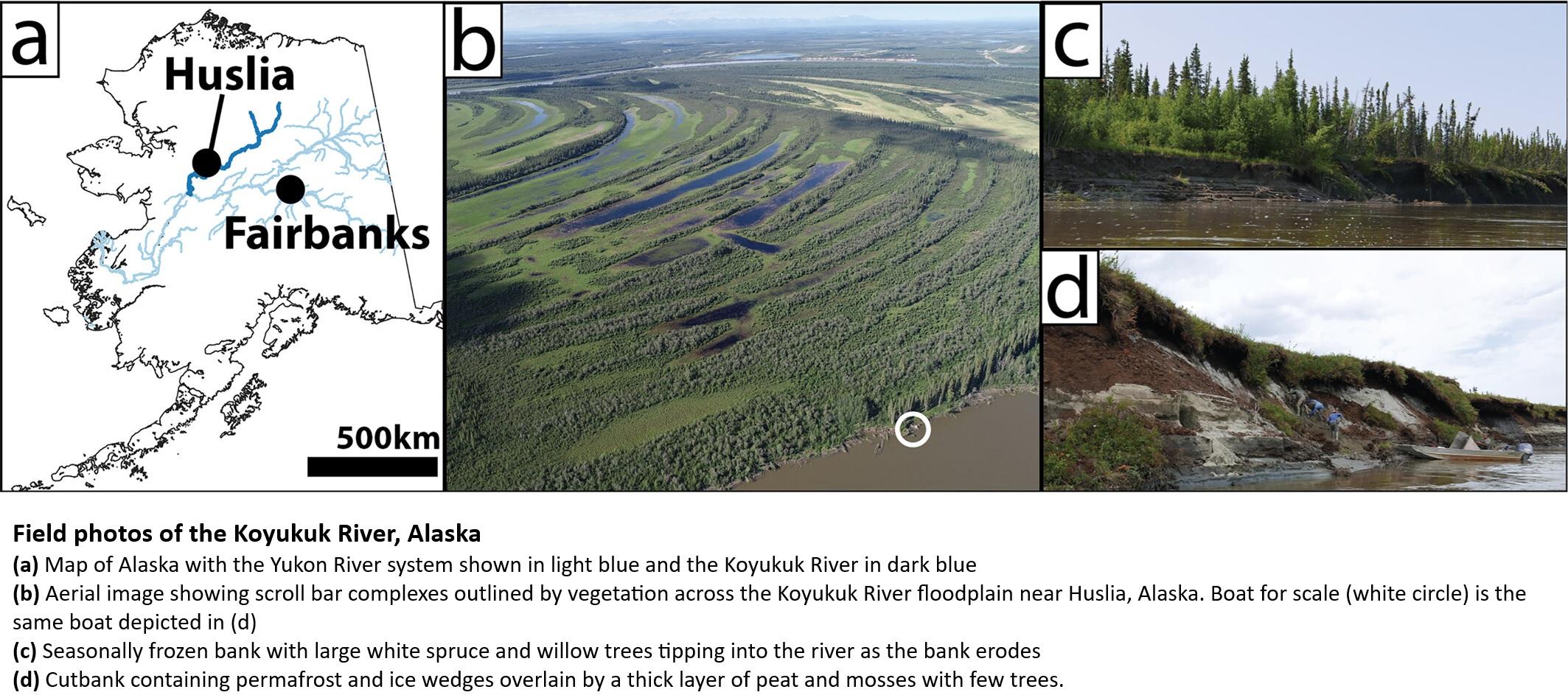
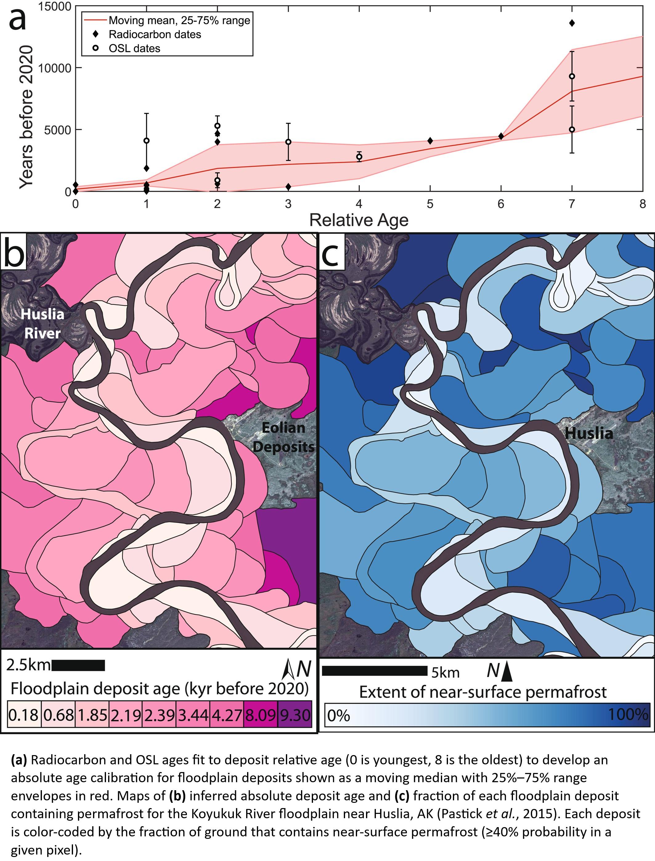
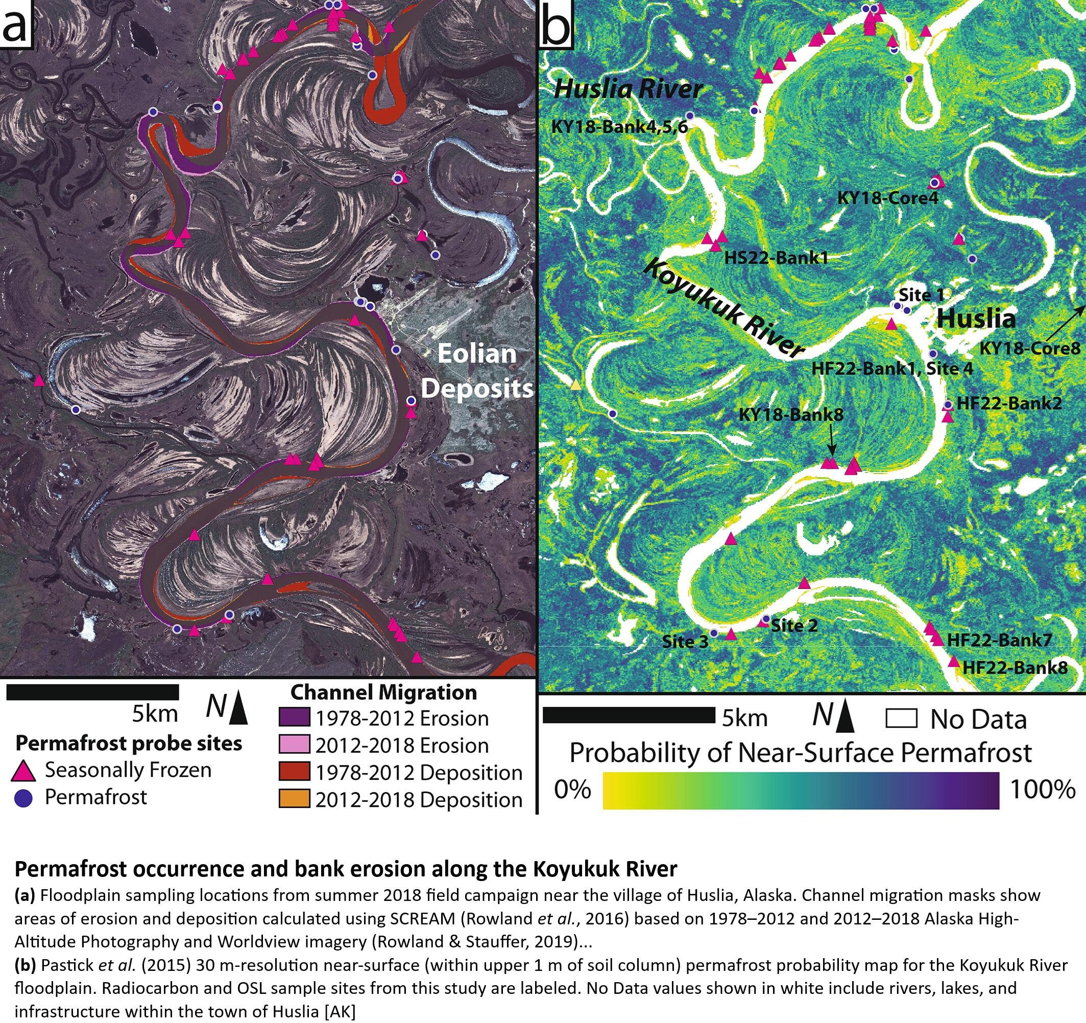
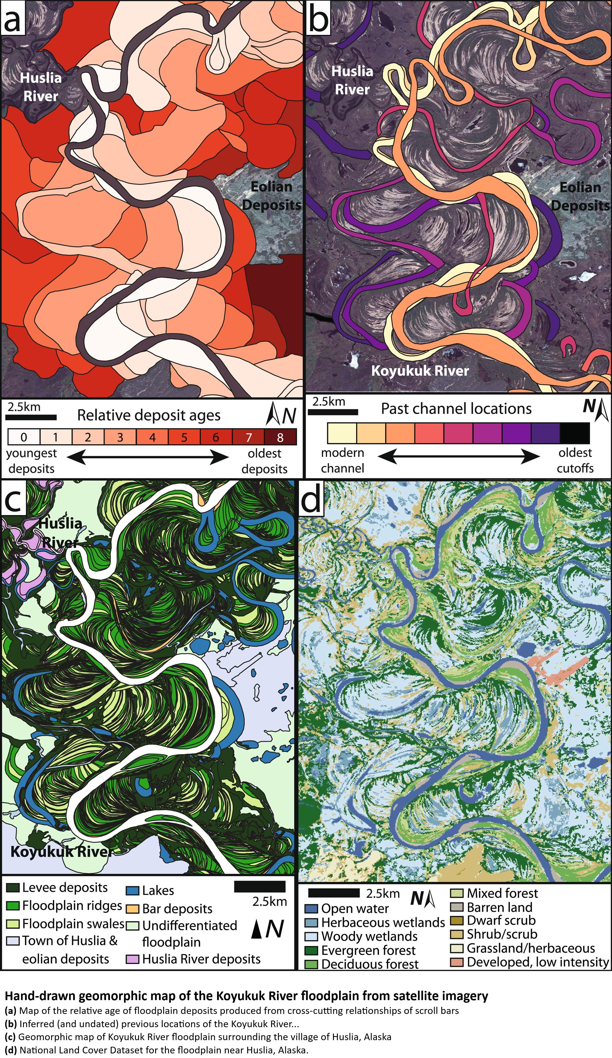
Permafrost Formation In A Meandering River Floodplain
--
https://doi.org/10.1029/2024AV001175 <-- shared paper
--
“... KEY POINTS:
• River meandering resets permafrost development and vegetation succession by eroding old floodplain areas and depositing new land
• On the Koyukuk River, permafrost rapidly forms in new deposits, but it takes over 4 Kyr to develop to its full areal extent of 85%
• The rate of permafrost formation is likely linked to vegetation succession on younger and overbank deposition on older floodplain areas…”
#water #hydrology #permafrost #development #research #Alaska #river #stream #watercourse #channel #meandering #vegetation #spatialanalysis #erosion #floodplain #overbank #deposition #sedimentation #KoyukukRiver #riverdynamics #climate #climatechange #Arctic #environment #landform #geomorphology #dating #spatiotemporal #model #modeling #network #GIS #spatial #mapping

Agree: no more #boondoggle #Borg - like "#affordable" #housing in #toxic #Gowanus #floodplain

And yet, the #building boom continues in #Gowanus, a #floodplain which will be inundated with #toxic #sludge it's called SHORT - TERMISM
https://www.sciencealert.com/millions-of-buildings-threatened-by-rising-seas-this-century-study-warns #realestate #climate #construction

Crepuscular scene, Fredericton. 2025
#SilentSunday #Photography #NashwaakRiver #Floodplain

Floodplain Mapping - An Age-Old Practice Updated For Today's Flooding Events
--
https://woolpert.com/news/blogs/floodplain-mapping-an-age-old-practice-updated-for-todays-flooding-events/ <-- shared technical blog post
--
[this post should not be considered an endorsement of this specific vendor, rather sharing an informative technical article]
#GIS #spatial #mapping #opendata #model #modeling #flood #floodplain #flooding #3DHP #NHD #remotesensing #LiDAR #risk #hazard #water #hydrology #geohazard #river #terrace #elevation #climatechange #extremeweather #photogrammetry #property #infrastructure #mitigation #engineering #event #agriculture #storm #rainfall #precipitation #regulations #design #construction #seasonal #damage #cost #economics #cropland #lowlands #data #topography #geomorphology #geomorphometry
@USGS @NOAA @nws

Happy #FootpathFriday from #Biederitz!
The #floodplain here is a very popular spot for walking, and it's also abundant with wildlife. The #bridge in the background is the B1 highway that leads to Magdeburg in a few minutes.
In December 2023 there was another Elbe flood and this floodplain was actually used to keep the water away from Magdeburg, by opening a nearby barrage. The area was under water for a few weeks, but recovered quickly.
#footpath #path #Weg #Wanderweg #landscape #landscapePhotography #nature #Natur #SilentSunday #stillerSonntag #Auenlandschaft #countryside #Brücke #bridge #bridgeObsession #Heyrothsberge #Umflutkanal
Floodplain Mapping - An Age-Old Practice Updated For Today's Flooding Events
--
https://woolpert.com/news/blogs/floodplain-mapping-an-age-old-practice-updated-for-todays-flooding-events/ <-- shared technical blog post
--
[this post should not be considered an endorsement of this specific vendor, rather sharing an informative technical article]
#GIS #spatial #mapping #opendata #model #modeling #flood #floodplain #flooding #3DHP #NHD #remotesensing #LiDAR #risk #hazard #water #hydrology #geohazard #river #terrace #elevation #climatechange #extremeweather #photogrammetry #property #infrastructure #mitigation #engineering #event #agriculture #storm #rainfall #precipitation #regulations #design #construction #seasonal #damage #cost #economics #cropland #lowlands #data #topography #geomorphology #geomorphometry
#USGS #NOAA #NWS


Hmm, I didn't know what else to post today, so here's another #SilentSunday from a recent walk around my village #Biederitz. And no, the only hobbit I saw was myself. Enjoy the rest of your day!
#stillerSonntag #trees #Bäume #Auenlandschaft #floodplain #landscape #landscapePhotography #countryside #summer #Sommer #Umflutkanal #Ehle
#stillerSonntag #trees #Bäume #Auenlandschaft #floodplain #landscape #landscapePhotography #countryside #summer #Sommer #Umflutkanal #Ehle


>https://www.texastribune.org/2025/07/09/texas-floods-growth-kerr-county-camp-mystic/
>Some people don’t have a choice but to live in flood-prone areas, where land is typically cheaper. **Often, cities and towns only allow cheaper housing like mobile and manufactured homes to go in places that carry a higher risk of flooding**, said Andrew Rumbach, a senior fellow at the Urban Institute who studies climate risk. When a weather disaster destroys a mobile home park, often it gets rebuilt right where it was, Rumbach said.
Well that's stupid and backwards.

Looking for some #Positivity to end the week? I have recapped 46 notable #Positive #Environmental and #ClimateChange articles from past month including: how many #ElectricVehicle chargers have been installed in the #UnitedKingdom, #Bangladesh working to bring back five plant species deemed critically endangered, restoring restoring #Floodplain #Wetlands cuts #Carbon #Emissions by 39% and nearly 47% of #Singapore being considered a green space.
https://primonatura.co.uk/positive-environmental-stories-016/

Despite the landmines and toxic sediment, this is an amazing example of the hidden potential of natural regeneration.
#Rewilding #Floodplain #Nature https://www.theguardian.com/environment/2025/jul/22/in-a-bombed-out-reservoir-ukraine-huge-forest-grown-a-return-to-life-or-toxic-timebomb?CMP=Share_iOSApp_Other

So much for those once in one hundred years, or once in a generation storms...
#rain #floodplain #rainyday #torrentialrain #montreal #polMTL #MTLpoli


"'It’s like pitching a tent in the highway,' Ms. Serra-Llobet said. 'It’s going to happen, sooner or later — a car is going to come, or a big flood is going to come.'”
"Around the country, construction is highly discouraged in river floodways, where deep and fast-moving waters are expected to travel during flood events, said Anna Serra-Llobet, a researcher at the University of California, Berkeley, who specializes in flood risk management.
She said it was particularly problematic to build a camp that houses children in an area so susceptible to flooding, & that efforts should have been made to relocate the cabins."
"Six years ago, when Camp Mystic pursued a $5 million construction project to overhaul and expand its private, for-profit Christian camp, no effort was made to relocate the most at-risk cabins away from the river. Instead, local officials authorized the construction of new cabins in another part of the camp — including some that also lie in a designated flood-risk area. The older ones along the river remained in use."
"The New York Times analyzed federal data to identify 19 cabins at Camp Mystic that were located in designated flood zones, including some in an area the county had deemed 'extremely hazardous.' The camp pursued an expansion project six years ago. Instead of relocating cabins to higher ground, it put new ones in the flood zone."
#Texas #floods #floodplain #CampMystic
/1
https://www.nytimes.com/interactive/2025/07/09/us/camp-mystic-texas-cabins.html

Client Info
Server: https://mastodon.social
Version: 2025.07
Repository: https://github.com/cyevgeniy/lmst