Lakers center Deandre Ayton to miss game tonight against Clippers https://www.rawchili.com/nba/435400/ #assist #Basketball #BasketballOperation #clipper #Clippers #CollegeBasketball #GLeagueTeam #GameTonight #LA #LAClippers #LAClippers #LakerCenterDeandreAyton #Lakers #LosAngeles #LosAngelesClippers #LosAngelesTimes #LosAngeles #LosAngelesClippers #NBA #pelinka #place #Point #rebound #rob #timme
#place
... General strike which is going to take place on 28-29 November 2025 under the slogan: “Say NO to the Meloni government's budget law – stand with ...
WFTU Solidarity Statement with the Strike in Italy 25 Nov 2025by central wftu The World Federation of Trade Unions, the militant voice of more that 105 million workers who live, work and struggle in 134 countries of the 5 continents, expresses its u…#wftu #solidarity #statement #strike #italy #nov #central #world #federation #trade #unions #militant #voice #million #workers #live #work #struggle #countries #continents #expresses #undivided #working #class #general #going #take #place #- #november #slogan #say #meloni #government #s #budget #law #stand #palestinian #people #stop #genocide #conscious #dignified #reaction #popular #strata #war #economy #preparations #reduce #resources #health #education #services #increase #precariousness #undermining #interests #pensioners #students #unemployed #international #class-oriented #union #movement #struggles #peace #immediate #end #wars #imperialist #intervention #affiliates #globe #fight #society #wealth #producers #will #allocated #produce #labor #toil #join #worker #just #demands #wage #permanent #stable #living #conditions #--- #dear #comrades #unione #sindacale #base #usb #salute #including #palestine #call #national #also #deeply #appreciate #long-lasting #unwavering #facing #resisting #israel #ongoing #years #settler-colonialism #apartheid #strikes #shed #bright #light #shameful #complicity #italian #corporations #enabling #illegal #occupation #palestinians #shown #power #inspired #many #across #dockworkers #called #september #october #recent #announced #well #disruptive #actions #preventing #stopping #military #cargo #ports #directed #genocidal #can #play #key #role #escalating #peacefully #disrupting #crimes #civil #large #response #meaningful #global #weekend #action #bds #welcomed #news #ceasefire #agreement #reached #however #continues #killing #starving #maiming #albeit #different #form #even #real #important #first #step #livestreamed #illegally #occupied #besieged #gaza #strip #without #massive #pressure #combined #trump-netanyahu #plan #constitutes #continuation #less #visible #us #hope #provoke #regional #outrage #boycotts #sanctions #repercussions #planned #annihilation #denial #refugees #rights #yet #won #needed #ever #begins #ending #serious #accountability #moral #legal #obligations #see #know #tide #turned #must #back #precisely #brought #wave #targeted #spain #t #rkyie #malaysia #colombia #slovenia #antigua #barbuda #governments #globally #isolated #internationally-wanted #prime #minister #recently #admitted #understood #desperate #attempt #relieve #isolation #save #-year-old #regime #settler-colonial #oppression #reasons #professional #urgently #renew #around #escalate #effort #colonial #calls #movements #put #center #adopt #highest #priority #mobilisations #express #liberation #self-determination #return #reparations #uphold #following #icj #rulings #starting #imposing #comprehensive #embargo #halting #sale #purchase #transfer #transit #parts #dual-use #items #ensuring #user #compliance #eni #halt #oil #petrol #launch #broad #intersectional #campaigns #compel #institutions #city #councils #universities #hospitals #etc #ethical #procurement #investment #policies #applicable #exclude #companies #knowingly #persistently #involved #grave #human #violations #particularly #humanity #forces #broader #economic #academic #cultural #sports #mahmoud #nawajaa #coordinator #committee #bnc #tras #el #anuncio #sindicato #syndicale #de #convocatoria #huelga #horas #para #pr #ximo #d #noviembre #frente #sindical #obrero #canarias #saluda #clase #obrera #italiana #sus #organizaciones #y #especialmente #organizaci #n #hermana #camaradas #fieles #nuestros #principios #manifestamos #todo #nuestro #apoyo #lucha #anticapitalista #apoyamos #esta #las #movilizaciones #que #dar #lugar #abrazo #fraternal #los #piquetes #autentica #vanguardia #saludo #asambleas #comit #muy #especial #juventud #trabajadora #convocada #abre #camino #toda #en #contra #presupuestos #guerra #militarizaci #econom #diferentes #pa #ses #sin #reservas #reivindicaci #inmediata #ruptura #concreci #palestina #libre #desde #rio #hasta #mar #les #deseamos #todas #suertes #fuerzas #todos #xitos #alguna #forma #sentimos #tambi #nuestra #viva #secretario #pol #tico #daniel #casal
Messaggi di solidarietà internazionale ad USB per lo sciopero generale del 28 novembre
Dodgers’ Shohei Ohtani to play for Japan in WBC, but will he pitch? https://www.rawchili.com/mlb/448173/ #Angels #Baseball #decision #Dodgers #Event #InternationalTournament #JAPAN #La #LAAngels #LAAngels #LosAngeles #LosAngelesAngels #LosAngeles #LosAngelesAngels #MLB #NextYear #ohtani #place #PlayoffOuting #RokiSasaki #season #SecondTime #SecondConsecutiveWorldSeriesTitle #wbc #YoshinobuYamamoto
How do #languages mix & new languages emerge as people #migrate from one #place to another? How did this process unfold in #SouthAsia? Join our panel of experts as we discuss this fascinating question.
📆 Mon, 1 Dec -- ONLINE only
🕒 3pm🇬🇧
For 🗣️ & 🆓 reg. details > https://tinyurl.com/2e7rcjdj
Free youth baseball clinic with former MLB players in Prunedale https://www.rawchili.com/mlb/444021/ #A.M. #at #Baseball #CastrovilleBoulevard #FormerMlbPlayer #FreeEvent #FreeYouthBaseballClinic #fundamental #game #legends #LifeSkill #ManzanitaPark #noon #place #prunedale #saturday
I went for my favorite burrito in FiDi and it was closed! Had to go to Los Tacos instead (no burritos, but yummy nonetheless).
#WTC #7WTC #financial #district #town #hall #NYC #district #courts #BigLaw #downtown #NewYorkCity #WorldTradeCenter #burrito #place #closed #tostada #quesadilla #salsa #yum
Teaching About Community and Place with Library of Congress Maps – Teaching with the Library
Teaching with the Library Primary Sources & Ideas for Educators
ISSN 2691-6916, Share & Subscribe to this blog
- Home
- Teaching About Community and Place with Library of Congress Maps
Teaching About Community and Place with Library of Congress Maps
November 18, 2025, Posted by: Colleen Smith, Share this post…
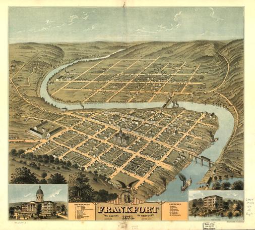
Teaching the concept of community to elementary students often emphasizes a local community that students are members of, such as a school, neighborhood, town, or city. Maps from the Library’s collections offer teachers a range of tools for helping students see, think about, and form questions to develop a sense of place.
For example, in the primary source set, Community: People and Places, a panoramic map gives students a particular perspective of a city.
Sometimes referred to as “bird’s-eye views,” panoramic maps are great for helping students see different landscapes, street patterns, and prominent buildings. These engaging visual maps can be especially meaningful to young learners. Browse maps by state to locate panoramic maps closest to where your students live.
How teachers use panoramic maps will vary depending what aspect of community they want to explore; however, a few ideas might include:
- Identify and trace waterways shown on a map. What do students notice about the waterway? What do they see on the map that is close to the waterway? Why might it be located there?
- Encourage students to look at street patterns. What clues can students find that tell them which streets have homes or buildings? Where are these streets located on the map?
- Project a contemporary map of the same city or town that the panoramic map shows. Ask: What do they notice about how the place has changed over time? What is different and what is similar?
- Older elementary students might spend time with the map key. Encourage students to look for patterns and ask questions about what types of institutions are included in the key, what surprises them, and why.
The “Additional Resources” section of the Community: People and Places primary source set includes Sanborn Maps, another type of map that could be helpful for exploring different aspects of community and place.
The Sanborn map collection includes large-scale maps of commercial, industrial, and residential sections of thousands of cities and towns in the United States, Canada, and Mexico. The maps show the shape and construction of homes, commercial buildings, and factories as well as names of streets and property boundaries. You can search the collection by state and then by city or county. A fascinating use of the Sanborn maps is to explore change over time. This essay details several examples and might inspire ideas to modify for elementary-age students.
Detail from a series of Sanborn Maps of Santa Fe, New MexicoIf you are looking for maps that go beyond a local orientation of community, the Cities and Towns Collection features maps that detail places throughout the world. These maps might be helpful as students start to orient to community in a state, national, or even global context.
If you use maps from these collections with your students, we would love to hear about it! Please share your experiences and teaching recommendations in the comments.
Continue/Read Original Article Here: Teaching About Community and Place with Library of Congress Maps | Teaching with the Library
#community #frankfortMap1871 #issn26916916 #kentucky #libraryOfCongress #libraryOfCongressBlog #maps #newMexico #place #sanbornMaps #santaFe #teachingWithMaps
Auckland woman stole $1.4m to buy house after alleged crypto savings vanished
“The theft committed by the employee … has had a profound effect,” the judge said before citing the…
#NewsBeep #News #Headlines #14m #after #alleged #auckland #bitcoin #buy #cash #couple #crypto #felt #Finally #home #house #immense #investing #NewZealand #NZ #parents #partner #place #pressure #READY #Savings #sharing #stole #their #they #to #under #vanished #were #with #woman #years
https://www.newsbeep.com/253015/
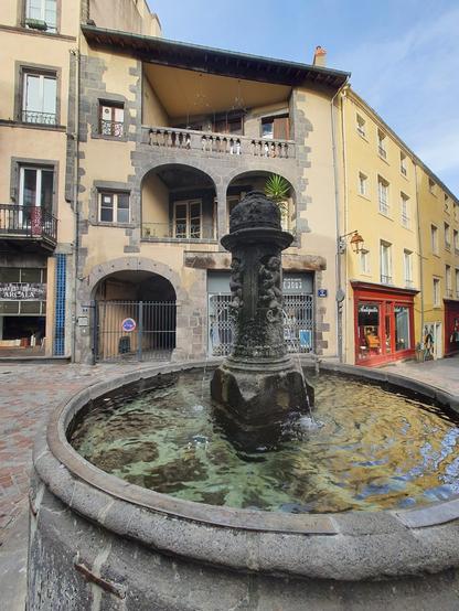
Clermont-Ferrand, place du Terrail.
#Auvergne #puydedome #ClermontFerrand #place #fontaine #fountain #ville #city #architecture #patrimoine #heritage
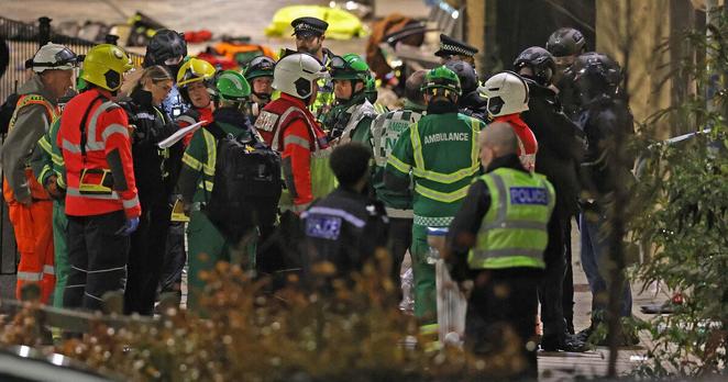
Three dead and 15 injured in Tenerife tidal surge
Strong waves have killed three people on Spain’s Canary Islands by pulling them into the Atlantic Ocean during…
#NewsBeep #News #Headlines #canaries #IE #Ireland #Place:International
https://www.newsbeep.com/239070/
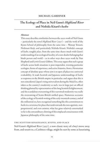
The Ecology of Place in Neil Gunn’s Highland River & Nishida Kitarō’s basho
Michael Gardiner, Scottish Literary Review 16.2, 2024 – reading Scottish & Japanese understandings of basho (place) as responses to the British empire in particular
3/5
https://muse.jhu.edu/pub/243/article/945000
#Scottish #literature #modernism #20thcentury #Japan #place #philosophy
Tauranga City Council closes Mauao, involves police after fireworks repeatedly used on sacred maunga
Thomson-Bache said the council had four Māori wardens on-site from 7pm to 11pm last night. “Despite their p…
#NewsBeep #News #Headlines #after #city #closes #closure #council #fireworks #full #involves #mauao #maunga #multiple #NewZealand #next #nights #NZ #on #over #overnight #place #police #repeatedly #sacred #says #tauranga #this #three #used #week #were #will
https://www.newsbeep.com/234383/
https://www.fogolf.com/1092288/chasing-the-fox-why-nz-holds-a-special-place-for-golfs-sling-king-mac-boucher/ Chasing the Fox: Why NZ holds a special place for golf’s sling king Mac Boucher #almost #Asked #Boucher #chasing #consider #Courses #FAVOURITE #for #fox #Golf #GolfNews #Golfs #holds #Instantaneously #King #Mac #NZ #Place #Responds #Sling #SPECIAL #The #why #Zealand
"This fight for political autonomy fostered a sense of local pride and a desire to express a distinct DC identity, one undeniably Black. The Blackbyrds’ music embodied that desire."
Charlotte Taylor Fryar for Orion: https://orionmagazine.org/article/the-rhythms-of-rock-creek-park/
#Longreads #Music #Sound #Ecology #Place #HipHop #WashingtonDC
Two British nationals confirmed as suspects in train stabbings
Two men born in Britain are suspected of carrying out the Huntingdon train knife attack, which is not…
#NewsBeep #News #Headlines #IE #Ireland #Place:EastAnglia #Place:UK
https://www.newsbeep.com/225203/
Ardmore fatal: One person dies after single-vehicle crash, cordons in place
Tom Rose Journalist·NZ Herald· 2 Nov, 2025 09:29 PMQuick Read Subscribe to listenAccess to Herald Premium articles require…
#NewsBeep #News #Headlines #after #ardmore #cordons #crash #died #dies #fatal #in #NewZealand #NZ #one #person #place #singlevehicle
https://www.newsbeep.com/225159/
#place : a court or short part of a street open only at one end
- French: Endroit
- German: der Ort
- Italian: luogo/posto
- Portuguese: lugar
- Spanish: lugar
------------
Word of The Hour's Annual Survey @ https://wordofthehour.org/r/form
Sfântul Ioan Gură de Aur: Să-i învățăm pe copii noștri să pună virtutea mai presus de orice Lucrul acesta să-l urmărim cu toţii. Să-i învăţăm pe copii noştri să pună virtutea mai presus de orice şi să socotească bogăţia – nimic. Nimic nu-i egal cu virtutea, nimic nu-i mai puternic decât ea 👉 https://c.aparatorul.md/cjcha 👈 #învăţare #avere #binecuvântarealuiDumnezeu #Bogăţie #copii #copil #CreştereaCopiilor #Dumnezeu #Lume #Moștenire #păcat #ParinteDeCopil #Plăce...
https://c.aparatorul.md/cjcha
Brad Marchand steps away to help friend whose daughter died https://www.rawchili.com/nhl/276007/ #BostonBruins #BradMarchand #Cancer #Daughter #Florida #FloridaPanthers #FloridaPanthers #friend #FriendJpMaccallum #Fundraiser #game #GameTuesdayNight #Halifax #Hockey #JPMacCallum #LastWeek #MarchAndMillCo.Hunters #MillCo.Hunter #NHL #NovaScotia #Panthers #place #SelahPanacciMacCallum #StanleyCupChampion #team #WCVB
Brad Marchand steps away to help friend whose daughter died https://www.rawchili.com/nhl/275193/ #Boston #BostonBruins #BostonBruins #BradMarchand #Bruins #Cancer #Daughter #FloridaPanthers #friend #FriendJpMaccallum #Fundraiser #game #GameTuesdayNight #Halifax #Hockey #JPMacCallum #LastWeek #MarchAndMillCo.Hunters #MillCo.Hunter #NHL #NovaScotia #place #SelahPanacciMacCallum #StanleyCupChampion #team #WCVB


