#seaLevelRise

2025-05-02

CA #wildfires: a warning to #NRC on #ClimateChange

January 16, 2025

"The NRC’s actions to address the risks from natural hazards do not fully consider potential climate change effects on severe nuclear accident risks. 'For example, NRC primarily uses historical data in its licensing and oversight processes rather than climate projections data,' the GAO report said.

"Beyond Nuclear has uncovered similar findings during our challenges to the NRC’s extreme relicensing process for extending reactor operating licenses, now out to the extreme of 60 to 80 years and talk of 100 years. We found that the agency’s staff believes and stubbornly insists that an #environmental review for climate change impacts (#SeaLevelRise, increasingly severe #hurricanes, extreme #flooding, etc.) on reactor safety and reliability is 'out of scope' for the license extensions hearing process.

"The GAO report points out to the NRC that wildfires, specifically, can dangerously impact US nuclear power stations operations and public safety with potential consequences that extend far beyond the initiating natural disaster. These consequences can include loss of life, large scale and indefinite population dislocation and uninsurable economic damage from the radiological
consequences:

" 'Wildfire. According to the NCA (National Climate Assessment), increased heat and drought contribute to increases in wildfire frequency, and climate change has contributed to unprecedented wildfire events in the Southwest. The NCA projects increased heatwaves, drought risk, and more frequent and larger wildfires. Wildfires pose several risks to nuclear power plants, including increasing the potential for onsite fires that could damage plant infrastructure, damaging transmission lines that deliver electricity to plants, and causing a loss of power that could require plants to shut down. Wildfires and the smoke they produce could also hinder or prevent nuclear power plant personnel and supplies from getting to a plant.'

"Loss of offsite electrical power (#LOOP) to nuclear power stations is a leading contributor to increasing the risk of a severe nuclear power accident. The availability of alternating current (AC) power is essential for safe operation and accident recovery at commercial nuclear power plants. Offsite fires destroying electrical power transmission lines to commercial reactors therefore increase the probability and severity of nuclear accidents.

"For US nuclear power plants, 100% of the electrical power supply to all reactor safety systems is initially provided through the offsite power grid. If the offsite electrical grid is disturbed or destroyed, the reactors are designed to automatically shut down or 'SCRAM'. Onsite emergency backup power generators are then expected to automatically or manually start up to provide power to designated high priority reactor safety systems needed to safely shut the reactors down and provide continuous reactor cooling, pressure monitoring, but to a diminished number of the reactors’ credited safety systems. Reliable offsite power is therefore a key factor to minimizing the probability of severe nuclear accidents.

"The GAO identifies a number of US nuclear power plant sites that are vulnerable to the possible outbreak of wildfires where they are located. 'According to our analysis of U.S. Forest Service and NRC data, about 20 percent of nuclear power plants (16 of 75) are located in areas with a high or very high potential for wildfire,' the GAO report states. 'More specifically, more than
one-third of nuclear power plants in the South (nine of 25) and West (three of eight) are located in areas with a high or very high potential for wildfire.' The GAO goes on to identify 'Of the 16 plants with high or very high potential for wildfire, 12 are operating and four are shutdown.'

"To analyze exposure to the wildfire hazard potential, the GAO used 2023 data from the U.S. Forest Service’s Wildfire Hazard Potential Map. 'High/very high' refers to plants in areas with high or very high wildfire hazard potential. Those #NuclearPower stations described by GAO as 'high / very high' exposure to wildfires and their locations are excerpted from GAO Appendix III: Nuclear Power Plant Exposure to Selected Natural Hazards.

Table 1: Potential High Exposure to “Wildfires” at Operating Nuclear Power Plants

–AZ / #SAFER, one of two mobile nuclear emergency equipment supply units in the nation, “HIGH / VERY HIGH”
–CA / #DiabloCanyon Units 1 & 2 nuclear power station, “HIGH / VERY HIGH”
–FL / #TurkeyPoint Units 3 & 4 nuclear power station, “HIGH / VERY HIGH”
–GA / #EdwinI. Hatch Units 1 & 2 nuclear power station, “HIGH / VERY HIGH”
–GA / $Vogtle Units Units 1, 2, 3 & 4, nuclear power station, “HIGH / VERY HIGH”
–NC / #BrunswickNPP Units 1 & 2 nuclear power station, “HIGH / VERY HIGH”
–NC / #McGuire Units 1 & 2 nuclear power station, “HIGH / VERY HIGH”
–NC / #ShearonHarris Units 1 & 2 nuclear power station, “HIGH /VERY HIGH”
–NB / #Cooper nuclear power station, “HIGH / VERY HIGH”
–SC / #Catawba Units 1 & 2 nuclear power station, “HIGH / VERY HIGH”
–SC / #HBRobinson Units 1 & 2 nuclear power station, “HIGH / VERY HIGH”
–WA / #ColumbiaNuclearPower station, “HIGH / VERY HIGH”

Table 2: Potential High Exposure to “Wildfires” at Shutdown Nuclear Power Plants

–CA / #SanOnofre Units 1 & 2, “HIGH / VERY HIGH”

–FL / #CrystalRiver, “HIGH / VERY HIGH”

–NJ / #OysterCreek, “HIGH / VERY HIGH”

–NY / #IndianPoint Units 1, 2 & 3, “HIGH / VERY HIGH”

"Wildfires can transport radioactive contamination from nuclear facilities

"A historical review of wildfires that occur around nuclear facilities (research, military and commercial power) identifies that these events are also a very effective transport mechanism of radioactivity previously generated at these sites and subsequently released into the environment by accident, spills and leaks, and careless dumping. The radioactivity is resuspended by wildfires that occur years, even decades later. The fires carry the radioactivity on smoke particles downwind, thus expanding the zone of contamination further and further with each succeeding fire. The dispersed radionuclides can have very long half-lives meaning they remain biologically hazardous in the environment for decades, centuries and longer."

cc: @Cyclist @stfn @collectifission

Read more:
beyondnuclear.org/ca-wildfires

#NoNukes #NoNukesForAI #RethinkNotRestart #NuclearPlants #NuclearPowerPlants #ClimateCrisis #Radiation
Geekoogeekoo
2025-04-27

Ghost forests are growing as sea levels rise, killing coastal woodlands and reshaping ecosystems. Climate change’s impact has never looked more haunting.

geekoo.news/ghost-forests-are-

2025-04-26

Atmospheric shifts accelerate Patagonian glacier loss, contributing to sea-level rise phys.org/news/2025-04-atmosphe Why are Patagonian glaciers rapidly losing mass? sciencedaily.com/releases/2025

#environment #glaciers #sea #SeaLevel #SeaLevelRise

2025-04-24

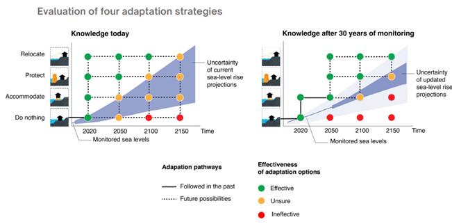
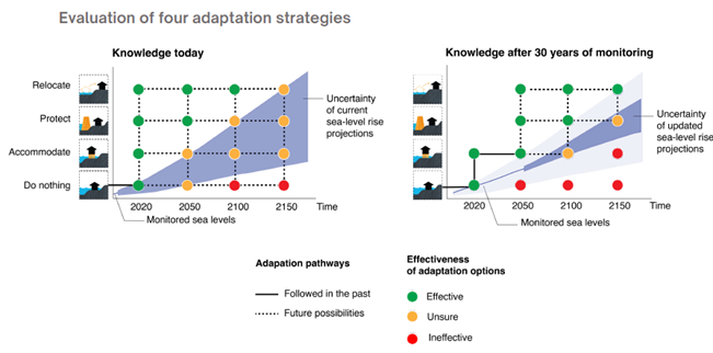
Preparing a talk + I'm struck again by this adaptation strategies by Voelz et al., 2024.

I think as ice sheet scientists we are sometimes too caught up in processes. Smart engineers + social scientists FTW - they have developed the kind of adaptation frameworks that can be used to modulate the effects of sea level rise on communities - Would still be cheaper and easier to reduce fossil fuel emissions though...

#SeaLevelRise

agupubs.onlinelibrary.wiley.co

Figure showing how adaptation to Sea level rise can evolve through time with monitoring to assess the likley level of sea level rise given 4 different adaptation strategies: Relocate, Protect, Accomodate and Do Nothing

Preparing a talk + I'm struck again by this adaptation strategies by Voelz et al., 2024. I think as ice sheet scientists we are sometimes too caught up in processes. Smart engineers + social scientists FTW #SeaLevelRise @h2020protect.bsky.social agupubs.onlinelibrary.wiley.com/doi/10.1029/...

Figure showing how adaptation to Sea level rise can evolve through time with monitoring
Ryan Hitereligiousryan
2025-04-20

🌍 Some nations may vanish by 2100
🌊 Rising seas are erasing countries like Kiribati, Tuvalu, and the Maldives
⚖️ They emit the least but suffer the most
A global injustice. A future at stake.
Full story👇
ryanjhite.com/2025/04/18/drown

2025-04-19

Global sea levels rose a whopping 125 feet after the last ice age | Live Science…

Melting ice caps in North America, Antarctica and Europe caused sea levels to rise quickly as temperatures warmed after the last ice age. But researchers have lacked robust... #sealevelrise #climate #icecaps

formuchdeliberation.wordpress.

Conspiracy of CartographersConspiracyOfCartographers
2025-04-17

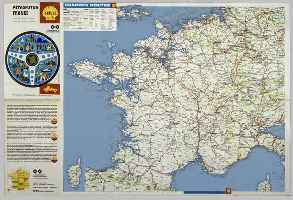
And finally, the of France 🇫🇷. The last of this series. 

66m sea level rise on a 1969 Shell Oil gas station map—when the world.s ice caps have melted. 

More:
 conspiracyofcartographers.com/


Petrofuture France—66m sea level rise on a 1969 Shell Oil road map of France
Conspiracy of CartographersConspiracyOfCartographers
2025-04-16

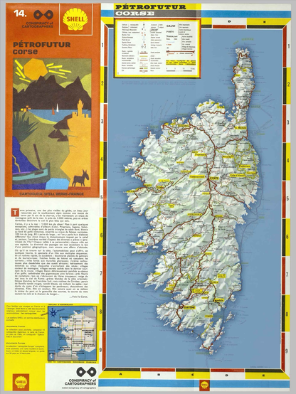
Across the water to the Corsica .

When the cryosphere has melted—66m sea level rise on a 1969 Shell Oil gas station map.

More:
 conspiracyofcartographers.com/

Petrofuture Corsica—a colorful 1969 Shell Oil roadmap with 66m sea level rise
2025-04-16

15-Apr-2025
Coastal threatened by climate change

Humans have always lived by and , and thus these locations are rich with sites. Natural and cultural resource management are conducted separately, despite the fact that climate change, , and threaten them both.

eurekalert.org/news-releases/1

2025-04-15

Senator #AngusKing fumes at #ClimateChange being nixed from annual threat assessment

Chris D’Angelo for The Maine Monitor April 8, 2025

"#Maine has been described as a 'climate haven,' [the same for #Vermont] a place expected to remain relatively sheltered from the most extreme and dangerous impacts of global climate change. But the #PineTreeState is far from immune.

"Fossil fuel-driven climate change is intensifying #HeatWaves, #flooding and other #ExtremeWeather events. Waters in the #GulfOfMaine are warming faster than nearly every other swath of ocean on the planet, threatening the future of the state’s signature #lobster industry and other #fisheries.

"Sea levels here are forecast to rise approximately 4 feet by the end of the century, forcing coastal communities, shipyards and military installations to prepare and adapt.

" 'This is a guaranteed threat,' said #AmyEshoo, director of #MaineClimateActionNow. 'It’s not one we can negotiate with. It’s not one that we can put #tariffs on. It’s not one we can go to the table with. We unleashed it. It’s here. We’re feeling its effects. Maine is definitely feeling them.' "

Read more:
mainebeacon.com/sen-king-fumes

#MaineWx #ClimateCatastrophe #SeaLevelRise #SenatorAngusKing

Conspiracy of CartographersConspiracyOfCartographers
2025-04-14

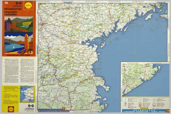
Skipping over Iberia from the Cote Basque, over to the Costa Brava & Languedoc.

The water gets up to Girona! Barcelona is almost entirely underwater!

Sous la mer, d'Avignon....

More:
 conspiracyofcartographers.com/

Petrofuture Langeudoc Costa Brava--66m sea level rise on a 1969 Shell Oil gas station map

The water gets up to Girona, Barcelona is almost entirely underwater, Avignon is underwater
Conspiracy of CartographersConspiracyOfCartographers
2025-04-14

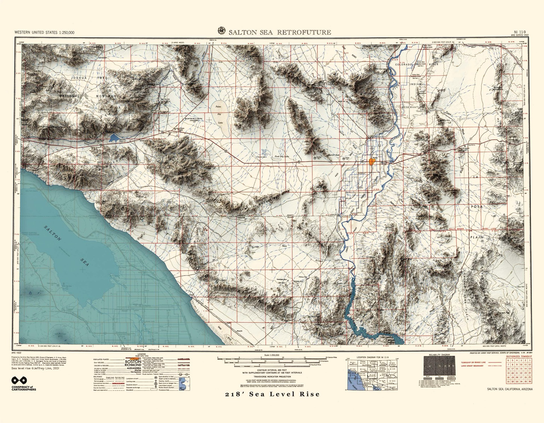
Another Valley map from the Retrofuture series…
The town of Coachella is to the northwest, this is the 1:250000 USGS quad of the Salton Sea, 1950, with 66m sea level rise. Also, check out Joshua Tree National Monument in the upper left.

More maps…conspiracyofcartographers.com/

A retrofuture map of Salton Sea—a 1950 USGS quad with 66m sea level rise.
Mix Mistress Alice💄MixMistressAlice@todon.eu
2025-04-13

"Due to rising temperatures, the Organization of Ibero-American States (EOI) has warned of new threats. The tiger mosquito, from Southeast Asia, has begun to colonize much of Catalonia and the Valencian Community. Tropical diseases such as malaria, Zika virus, Crimean-Congo hemorrhagic fever, West Nile virus, and others are re-emerging in Spain in areas where they were previously eradicated or never occurred, as high temperatures allow the vectors (mainly mosquitoes) that transmit them to persist."—Juanjo Santos

Spain Ranks First Among European Countries in Terms of Heat-Related Mortality >

climatescorecard.org/2024/08/s

#Spain #GlobalWarming #viruses #ExtremeHeat #IncreasedMortality #drought #TropicalDiseases #Cáceres #CiudadReal #Catalonia #Valencia #HeatRelatedDeath #biodiversity #TemperatureIncrease #SeaLevelRise #FoodInsecurity #water ##agriculture

Conspiracy of CartographersConspiracyOfCartographers
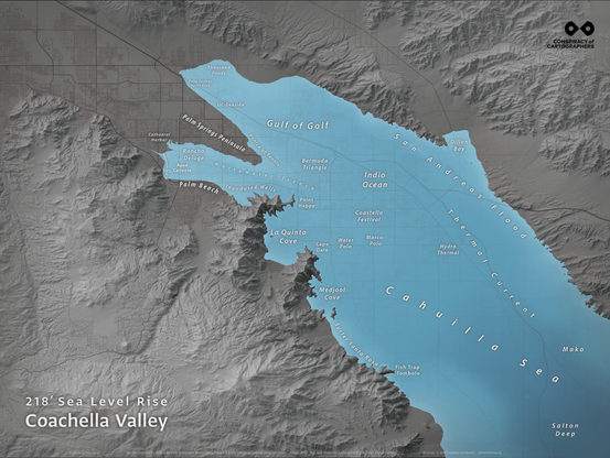
2025-04-13
Gray and blue map of the Coachella Valley with 66m sea level rise—most of the valley is flooded
Conspiracy of CartographersConspiracyOfCartographers
2025-04-12

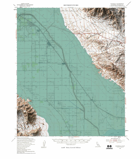
I hear is happening. Well, there’s a Retrofuture map for that…

Based on the 1941 USGS quad for Coachella, with 66m sea level rise.

This is a 1941 usgs map of Coachella. 66m sea level rise has been added—sea green water fills most of the valley.
Eric Benderebender00
2025-04-12

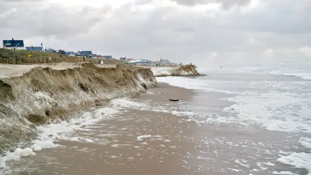
FEMA quietly removes access to New England coastal erosion hazard tool

Planners and resilience experts say long-term erosion maps had been critical

commonwealthbeacon.org/environ

The Coastal Erosion Hazard viewer on the Federal Emergency Management Agency website "predicted erosion risk across the coast for the years 2030, 2050, and 2100, and until recently was publicly accessible."

Photo of sandy coast being deeply eroded. Posted without credit with Commonwealth Beacon story.

Client Info

Server: https://mastodon.social
Version: 2025.04
Repository: https://github.com/cyevgeniy/lmst