
Arnis Brings the World to Minecraft: Bedrock Edition https://hackaday.com/2026/01/17/arnis-brings-the-world-to-minecraft-bedrock-edition/
#Games #SoftwareHacks #3Dmapping #Elevation #Generation #Minecraft
#3Dmapping

Arnis Brings the World to Minecraft: Bedrock Edition
![<div><img alt="" class="attachment-large size-large wp-post-image" height="224" src="https://hackaday.com/wp-content/uploads/2026/01/logo.png?w=800" style="margin: 0 auto; margin-bottom: 15px;" width="800" /></div><p>A couple of years ago, we covered a project called Arnis, created by [Louis Erbkamm], which allowed you to generate any portion of Earth into <em>Minecraft</em> blocks and maps. It was already impressive, but since we last checked in the open source project <a href="https://arnismc.com/" target="_blank">has made some incredible progress</a>.</p>
<p><a href="https://hackaday.com/2024/12/30/bringing-openstreetmap-data-into-minecraft/">When we first covered Arnis</a>, it was stuck on the Java edition of Minecraft. But now the project has been updated to support the more modern Bedrock Edition, meaning you can put your home into any device’s version of Minecraft!</p>
<p><img alt="" class="size-medium wp-image-904983 alignright" height="212" src="https://hackaday.com/wp-content/uploads/2026/01/preview.jpg?w=400" width="400" /></p>
<p>Beyond Bedrock version support, the actual tool has improved with proper elevation generation using data provided from NASA. This allows you to view the Alps or the Himalayas in all their voxel glory, or explore an entire map of the Moon. Perhaps what’s even more impressive is that the generation is accurate enough to be used in an <a href="https://www.researchgate.net/publication/384644535_Floodcraft_Game-based_Interactive_Learning_Envir](https://files.mastodon.social/cache/media_attachments/files/115/915/149/146/434/478/original/9c67447920474754.png)

🧭 **Làm 'sống lại' Kinh đô Thăng Long và tinh thần đạo học**
Triển lãm trình chiếu 3D Mapping "Kinh đô Thăng Long" kết hợp trưng bày "Đạo học ngàn năm" đã thành công tái hiện hình ảnh Kinh đô Thăng Long cổ xưa và khơi dậy tinh thần đạo học trong cuộc sống đương đại.
#ThangLong #KinhDoThangLong #DaoHoc #DiSan #VanHoaVietNam #Heritage #Culture #3DMapping
https://vietnamnet.vn/lam-song-lai-kinh-do-thang-long-va-tinh-than-dao-hoc-2477622.html

Ein Forschungsteam der TU #München hat erstmals weltweit alle #Gebäude erfasst.
Der Global Building Atlas dokumentiert 2,75 Milliarden Bauten und liefert 3D-Daten zu Volumen und Höhe. Die Analyse zeigt deutliche Unterschiede beim #Gebäudevolumen pro Person.
Während #Finnland fast 4000 Kubikmeter bietet, sind es in #Niger nur 14. Die Daten sollen helfen, #Stadtentwicklung gezielter zu planen und soziale Ungleichheiten sichtbar zu machen.
https://www.n-tv.de/wissen/So-viele-Gebaeude-gibt-es-heute-auf-der-Erde-id30099940.html

Measured in cm, mapped in meters, oops. Hopefully it'll render okay tomorrow. #f4map #OpenStreetMap #3dmapping


Whoops: Your ‘Smart’ Vacuum May Be Broadcasting A 3D Map Of Your Home
Đêm "Lửa Xô Viết" tái hiện tại Bảo tàng Nghệ An vào ngày 12/9, sử dụng nghệ thuật biểu diễn và công nghệ 3D mapping để kể câu chuyện lịch sử hào hùng của Xô Viết Nghệ Tĩnh.
#NgheAn #XoVietNgheTinh #LichSu #BaoTang #3DMapping #NghệAn #XôViếtNghệTĩnh #LịchSử #BảoTàng
https://vietnamnet.vn/tai-hien-dem-lua-xo-viet-tai-bao-tang-nghe-an-2440501.html
Tháp Rùa rực rỡ trong đêm với màn trình diễn 3D Mapping, tái hiện huyền thoại khai mở đất kinh kỳ, thu hút hàng nghìn người dân đến chiêm ngưỡng tại Hồ Hoàn Kiếm! ✨🐢
#ThapRua #HoHoanKiem #3DMapping #VanHoa #HaNoi #TurtleTower #HoanKiemLake #Culture #Hanoi #ThápRùa #HồHoànKiếm #VănHoá #HàNội
Hà Nội rực rỡ với màn trình chiếu 3D mapping khổng lồ kết hợp pháo hoa nghệ thuật tại Quảng trường Cách mạng Tháng Tám tối 15/8! ✨🎆 Hàng nghìn người đã đến chiêm ngưỡng sự kiện hoành tráng này.
#Hanoi #3Dmapping #Fireworks #Vietnam #HàNội #PháoHoa #NghệThuật #ViệtNam

La constellation CO3D partira le 26 juillet et pourrait offrir une cartographie 3D en haute résolution, utile aussi à l’armée via MUSIS.
https://www.numerama.com/sciences/2038463-depart-imminent-dune-constellation-de-satellites-qui-interesse-de-pres-larmee-francaise.html
#Space #Science #Astrophysics #CO3D #EarthObservation #3DMapping #DualUseTech #CNES

🚀 Oh, joy! Now you can finally text your way to historical enlightenment through a 3D map simulation platform that claims to have "spatial intelligence." Because what history has been desperately missing is the opportunity to wander around in cartoonish 3D landscapes. 😂🌍
https://mused.com/map/ #3DMapping #SpatialIntelligence #HistoricalEnlightenment #TechInnovation #EdTech #HackerNews #ngated

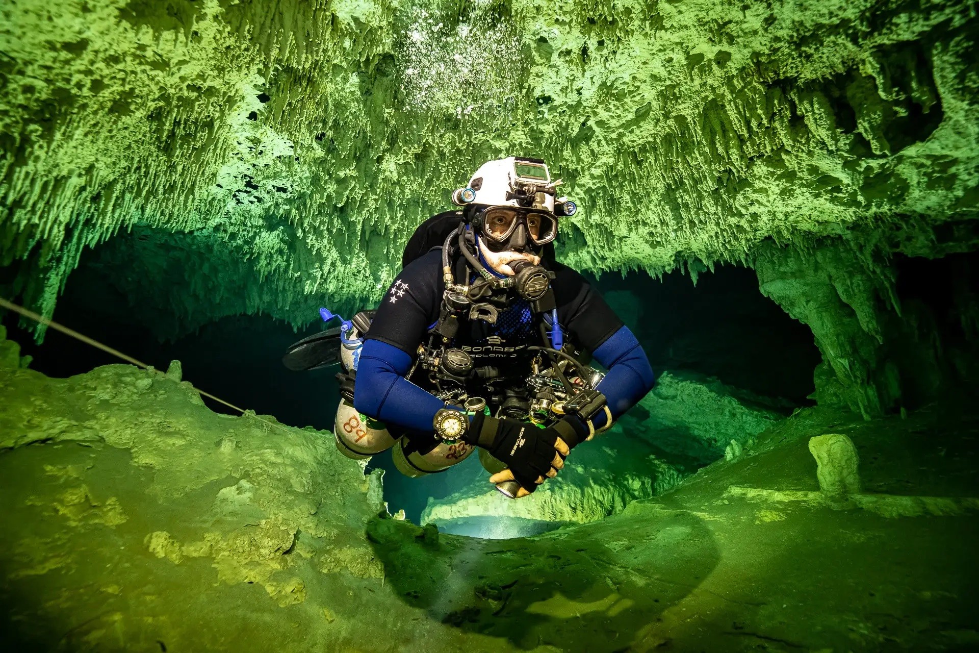
The Affordable DIY Mandeye Lidar System For Surveying Caves, And How To Convert 3D Clouds Into Traditional Cave Ground Plans And Extended Profiles
--
https://doi.org/10.5038/1827-806X.53.3.2535 <-- shared paper
--
#GIS #spatial #mapping #LiDAR #cave #cavediving #cavemapping #speleology #workflow #survey #remotesensing #pointcloud #mobilemapping #3Dmapping #profile #model #modeling #3dmodel #opensource #openhardware #reproducible #affordable #DIY #Mandeye


Gefährliche Gebiete sicher erkunden? Mit dem Projekt 3D-InAus vom Fraunhofer FKIE erstellt ein Roboter präzise 3D-Karten dank LiDAR-Technologie.
1,3 Millionen Laserimpulse/Sekunde + Kamerabilder ergeben eine exakte Visualisierung. Mehr zu den Einsatzmöglichkeiten hier: https://s.fhg.de/J28
#Technologie #Innovation #3DMapping
GIS Corps Is Looking To Help Phreatic With Remote Spatial Volunteers
--
https://www.phreatic.org/ <-- shared home page
--
https://www.giscorps.org/become-a-volunteer/ <-- shared link to volunteer with GIS Corps
--
[want to be a part of some super interesting (remote) GIS volunteer work?!]
#GIS #spatial #mapping #volunteer #phreatic #explore #protect #seacaves #Sardinia #cave #caving #Phreatic #GISCorps #Italy #Supramonte #GulfofOrosei #model #3dmapping #environmental #speleology #hypogene #groundwater #waterresources #marine #marinecaves #coast #coastal
@GISCorps @Phreatic


The Oldest Three-Dimensional Map In The World Discovered In A Paleolithic Cave Near Paris
--
https://www.labrujulaverde.com/en/2025/01/the-oldest-three-dimensional-map-in-the-world-discovered-in-a-paleolithic-cave-near-paris/ <-- shared article
--
https://doi.org/10.1111/ojoa.12316 <-- shared paper
--
#GIS #spatial #mapping #cave #archeaology #3dmapping #Segognole #quartzitic #sandstone #megaclast #lagdeposit #France #ParisBasin #carving #shelter #water #hydrology #watercourses #hydrology #map #historic #geomorphology #geomorphometry #model #3dmodel #Paleolithic #huntergatherers #NoisysurÉcole #hydrographic #rivercourse #prehistory


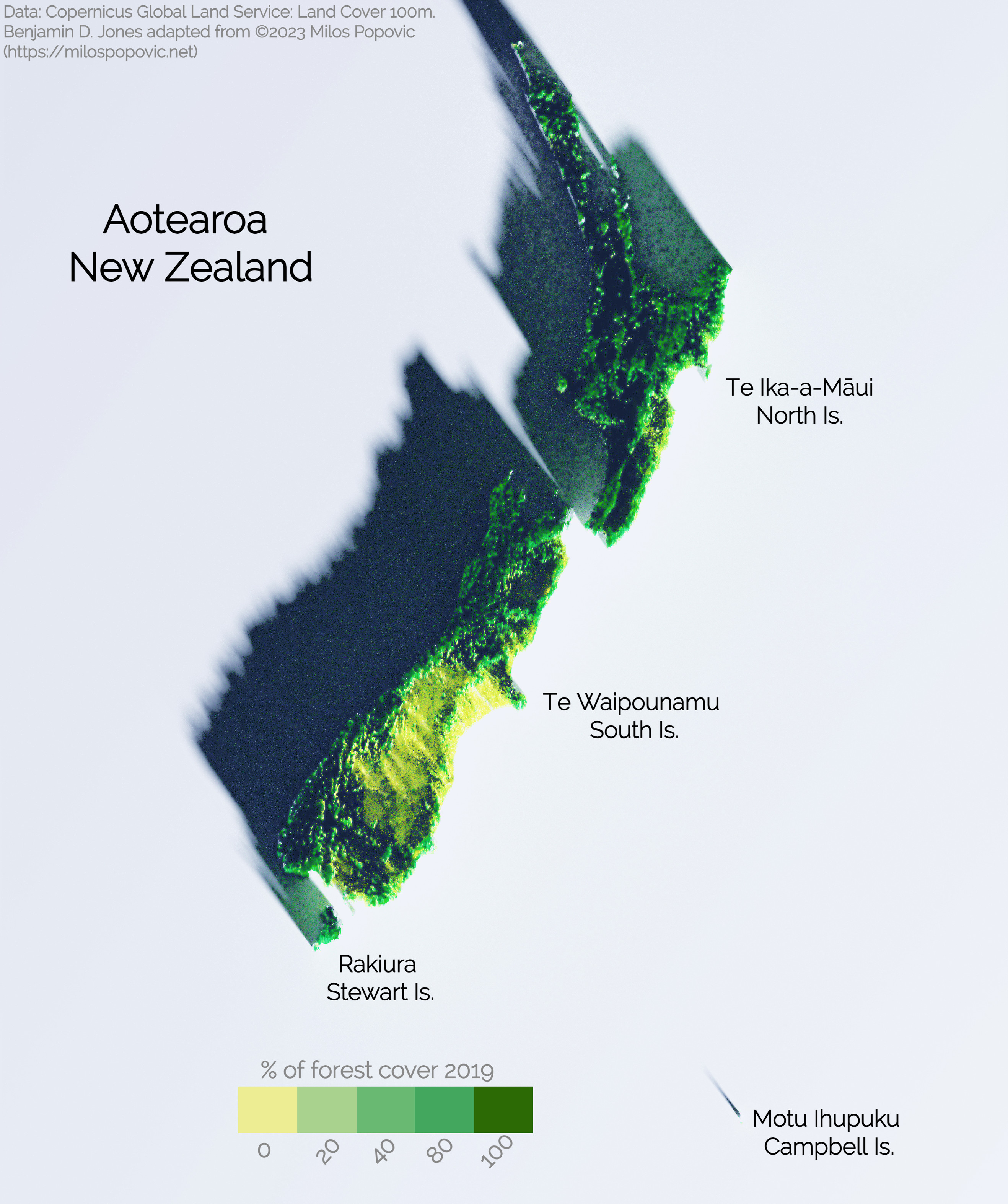
Copernicus 100m 2019 3-D forest cover map of Aotearoa / New Zealand. Inspiration from Milos Popovic, PhD "3D map with rayshader and ggplot2 in R" tutorial on youtube.
#DataVisualization #RProgramming #R #SpatialAnalysis #GeospatialMapping #3DMapping #DataScience
New York Will Plant Thousands Of Trees Using New Tech To Maximize Foliage Impact
--
https://www.theguardian.com/us-news/2023/nov/30/new-york-city-tree-planting-lidar-mapping <-- shared media article
--
https://labs.aap.cornell.edu/daslab/projects/treefolio <-- Tree Folio NYC, a 3D mapping tool
--
https://www.jillhubley.com/project/nyctrees/#GIBI <-- NYC Street Trees By Species [webmap]
--
#GIS #spatial #mapping #LiDAR #remotesensing #vegetation #trees #treeplanting #newyork #newyorkcity #NYC #maps #survey #canopy #urbanforest #heatstress #heatsink #heatisland #environmentaljustice #environment #environmentalscience #city #cities #planning #urbandesign #urbanplanning #TreeFolioNYC #Cornell #climatechange #species #3dmapping #visualisation #publichealth


Mapping the ‘dark universe’ https://www.bbc.com/news/science-environment-67343374
#Euclidtelescope had a problem locking on to a "guide star" during early testing. Until engineers could upload new software to its fine guidance sensor, the observatory was swivelling all over the sky.
#Euclid has 6 years to 3D map of one-third of the sky. The telescope combines breadth, depth and sharpness of vision.
ASPRS Approves Edition 2 of the ASPRS Positional Accuracy Standards for Digital Geospatial Data
--
https://www.asprs.org/revisions-to-the-asprs-positional-accuracy-standards-for-geospatial-data-2023 <-- shared technical article
--
https://publicdocuments.asprs.org/PositionalAccuracyStd-Ed2-V1 <-- download the current ASPRS current document
--
#GIS #spatial #mapping #gischat #ASPRS #precision #accuracy #standards #data #spatialdata #PositionalAccuracyStandards #survey #surveying #workinggroup #confidencelevel #metrics #measurement #checkpoints #groundcontrol #VWA #remotesensing #LiDAR #3dmapping #UAS #photogrammetry #geomorphometry


A New, Underground Atlas Of Subduction Zones
--
https://eos.org/articles/a-new-underground-atlas-of-subduction-zones <-- shared technical article
--
https://submap.gm.umontpellier.fr/ <-- Submap, a tool for mapping subduction zones
--
“Graphic design meets geoscience…
Submap [link above] is a user-friendly tool that allows anyone with an Internet connection to create quick, custom maps of subduction zones…"
#GIS #spatial #mapping #visual #visualisation #visualization #subduction #geology #structuralgeology #Submap #geoscience #global #earth #platetectonics #subductionzones #earthquake #model #modeling #3dmapping #3dmodeling #opensource #opendata #tsunami #monitoring #fault #faulting #VisualizationTools #maps #crosssections
Client Info
Server: https://mastodon.social
Version: 2025.07
Repository: https://github.com/cyevgeniy/lmst