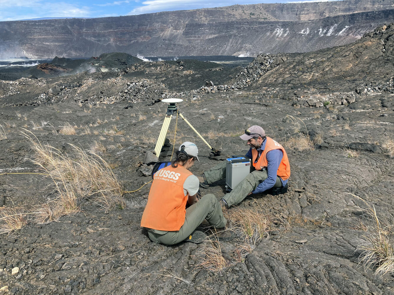
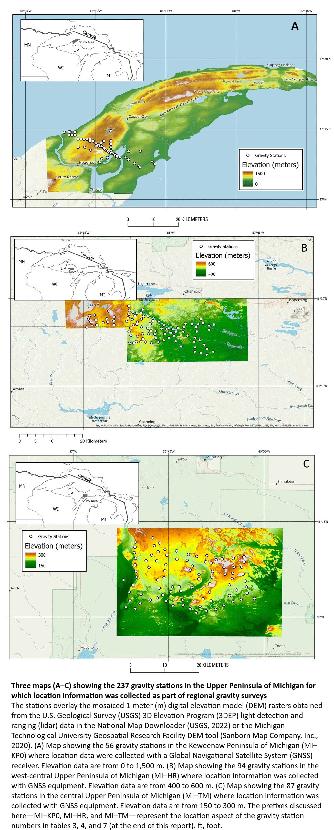
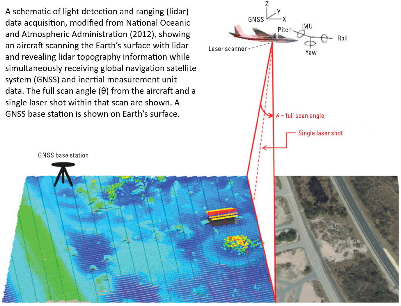
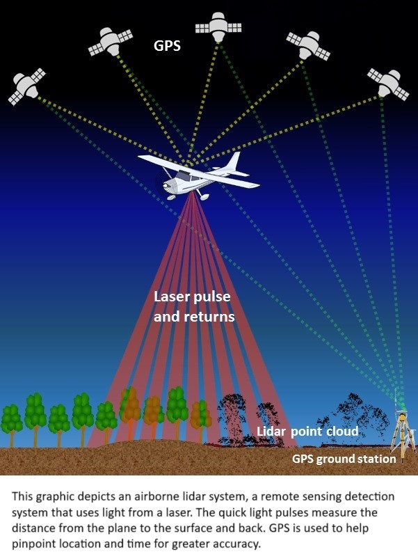
The Feasibility Of Using LiDAR-Derived Digital Elevation Models [DEMs] For Gravity Data Reduction
--
https://www.usgs.gov/3d-elevation-program/news/feasibility-using-lidar-derived-digital-elevation-models-gravity-data <-- shared article
--
https://pubs.usgs.gov/publication/ofr20251019 <-- shared report
--
“A nice report from our colleagues in the USGS Mineral Resources Program on the feasibility of lidar-derived DEMs, including 3DEP data, for gravity data reduction…”
#GIS #spatial #mapping #3dep #elevation #fedscience #remotesensing #earthobservation #gravity #submetre #accuracy #precision #dGNSS #GNSS #global #navigation #satellite #GPS #LiDAR #DEMs #gravimetrics #milligals #Bouguer #anomaly #monitoring #corrleation #refinement #datareduction #appliedscience #usecases
@USGS
#3dep

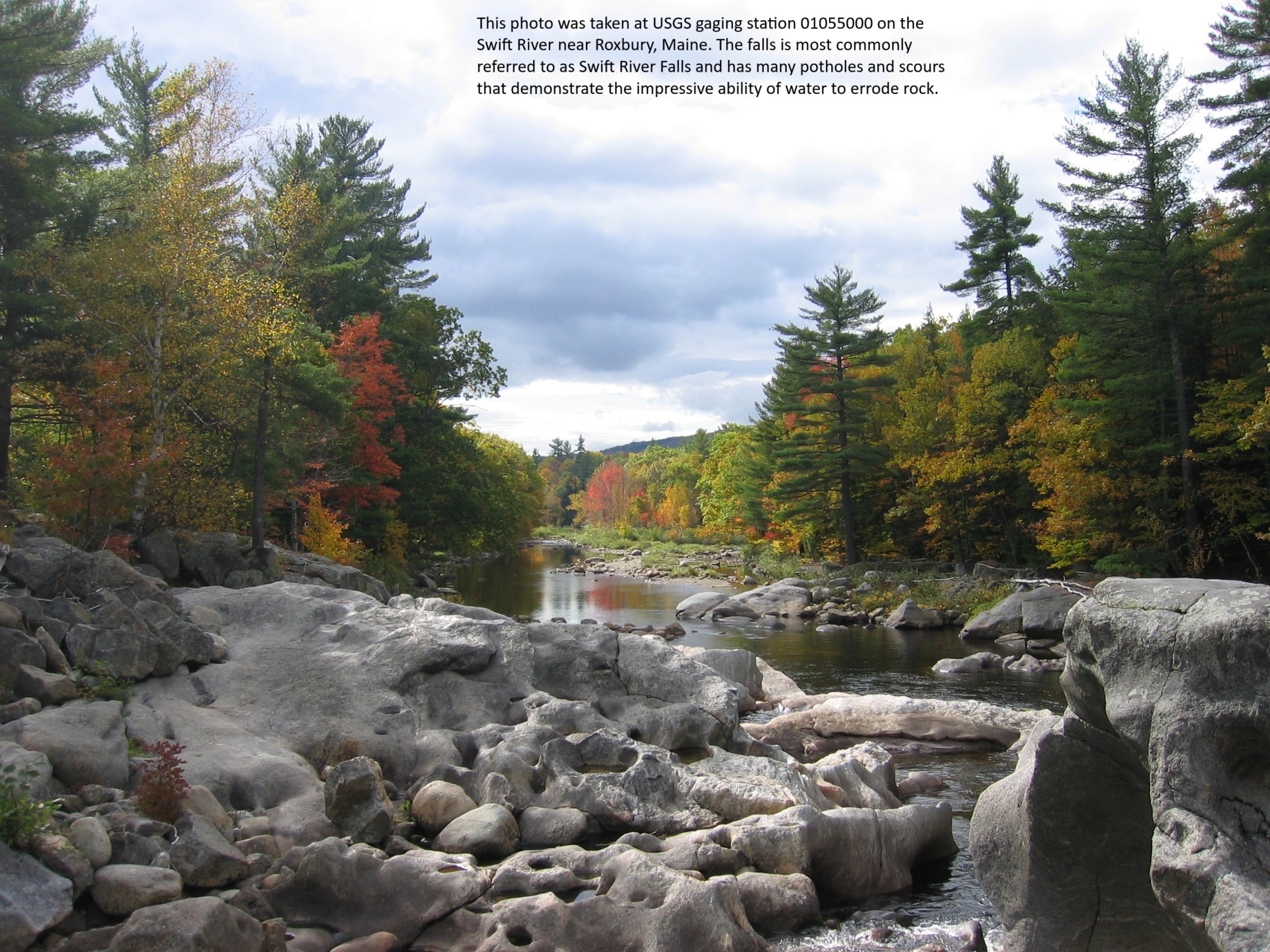
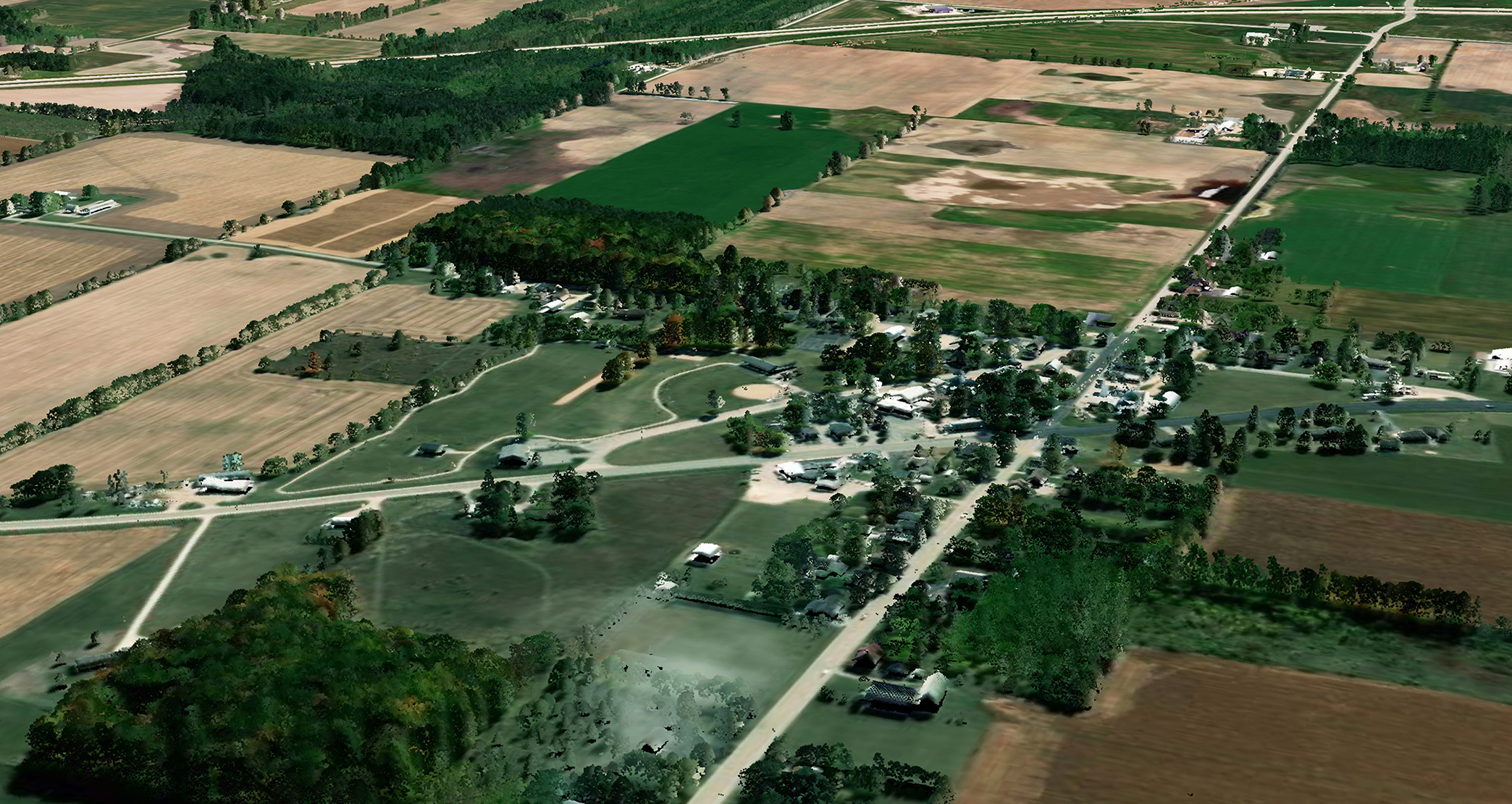
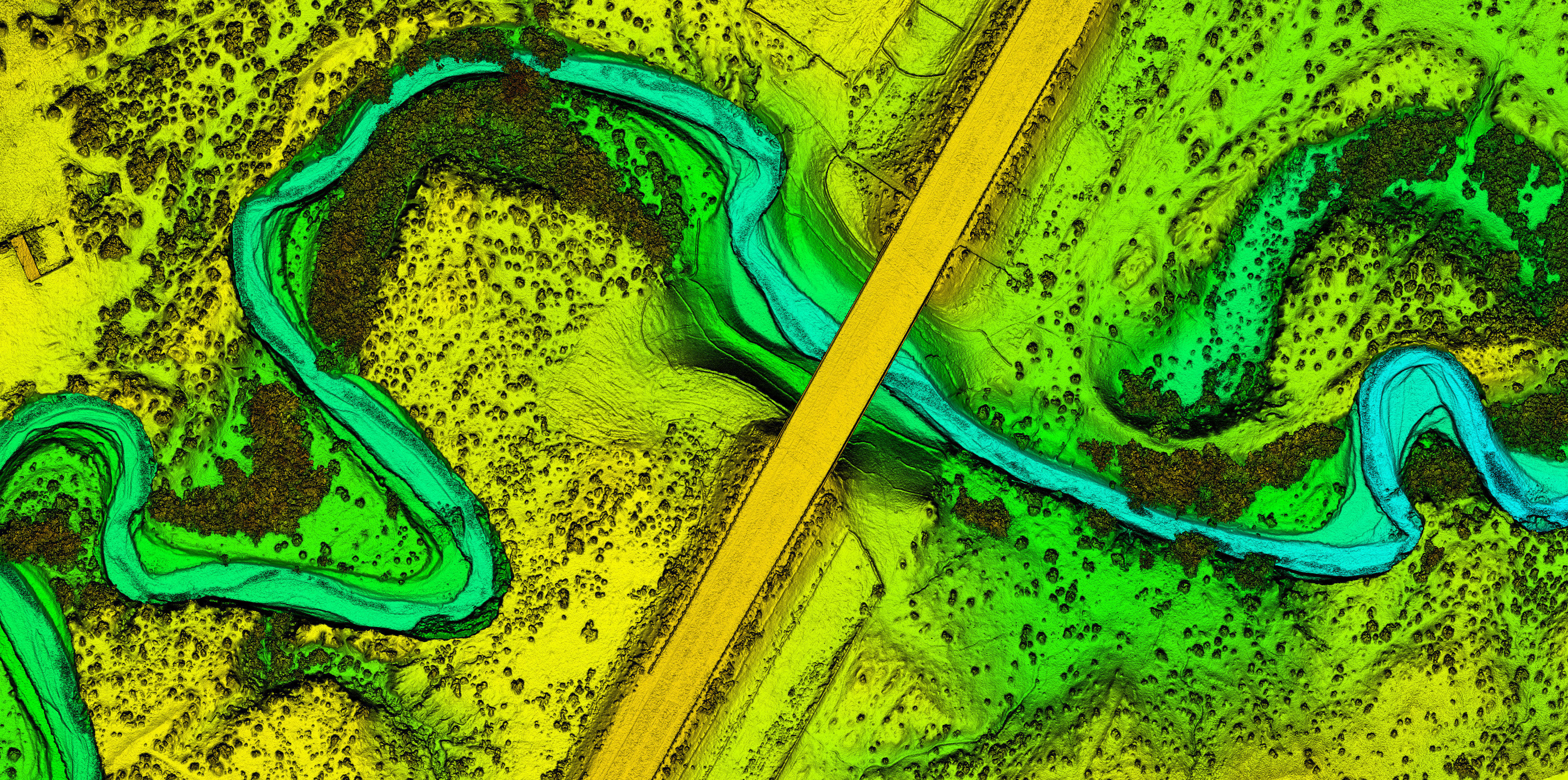
Fluvial System Block Diagrams
--
I was looking to understand a fluvial system the other day, up in the high Arctic, as I looked at 3DEP remote sensed elevation data… I have always been fascinated by the how geology, water, weather shapes a landscape, including erosion (aka geomorphology if you will) – and realized how very much value fluvial block diagrams have as we try to conceptualise what has, is and will happen(ed.)
#spatial #spatiotemporal #morphology #meander #levee #understanding #oxbow #pointbar #river #water #hydrology #landform #geomorphology #geomorphometry #geology #fluvial #riverine #weather #climate #erosion #sediment #sedimentation #Arctic #3dep #opendata #DEM #BeringSea #northslope #opendata #fedservice


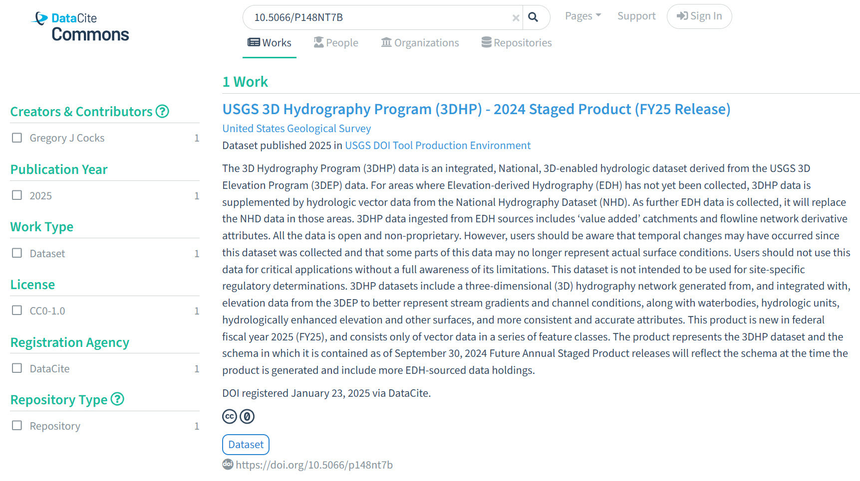
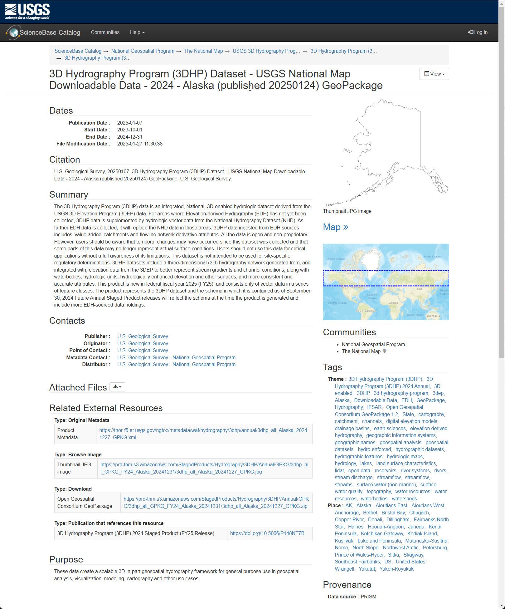
I Am Proud To Be Part Of The Integrated Team Generating and Publishing An Open Data 3DHP Hydrology Spatial Data Product For The Nation At The USGS
--
https://doi.org/10.5066/P148NT7B <-- shared product DOI
--
https://commons.datacite.org/doi.org?query=10.5066%2FP148NT7B <-- shared DateCite repository record
--
https://3dhp.nationalmap.gov/ <-- 3DHP data is also available via a USGS spatial data service (with select & export capability)
--
[‘my’ first product DOI generation & publication as well ~smile~]
#GIS #spatial #mapping #data #water #hydrology #LiDAR #EDH #elevationderivedhydrography #3DHP #opendata #publicdata #DOI #stagedproducts #3DTNM #3DEP #NHD #national #USA #nonproprietary #waterresources #spatialanalysis #model #modeling #3d #vector #schema #DOI#geopackage #filegeodatabase #metadata #XML
@USGS

Happy New Year and Happy Mapping in 2025!
I plan to boost some #introductions over the next few weeks. It's exciting to see a new wave and I hope that you enjoy the Fediverse!
In the meantime, I've been working on refining a recipe for relative elevation models (REMs) using Dan Coe's methods. My 2025 goal is to cover most of the #Virginia rivers, but we'll see.
Check out @FediTips for tips on how to use Masto.

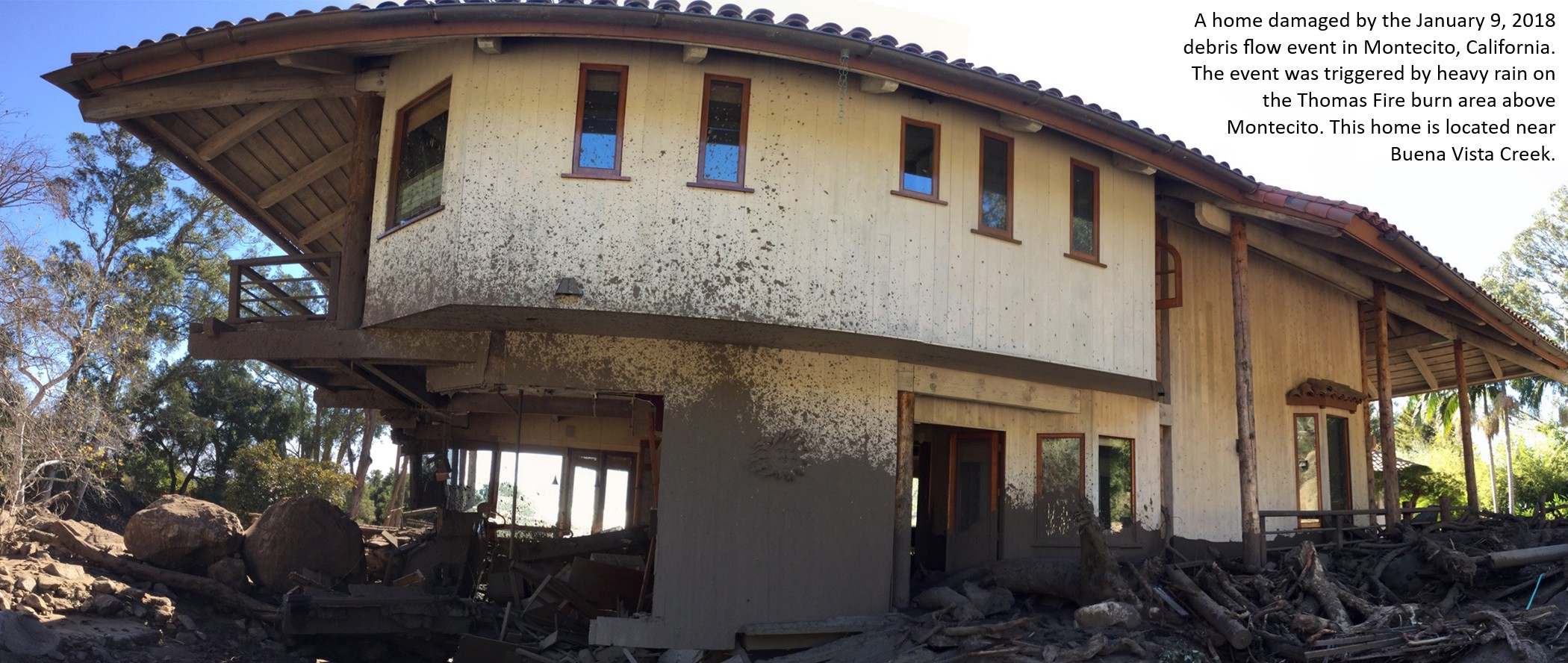
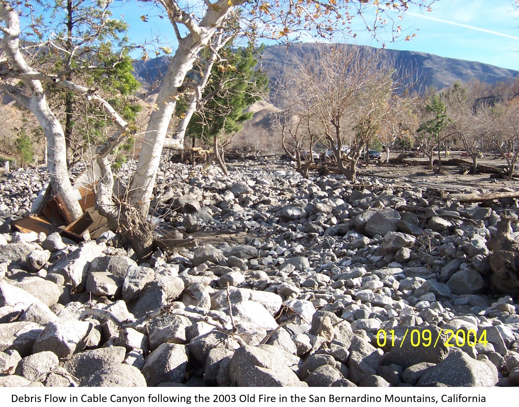
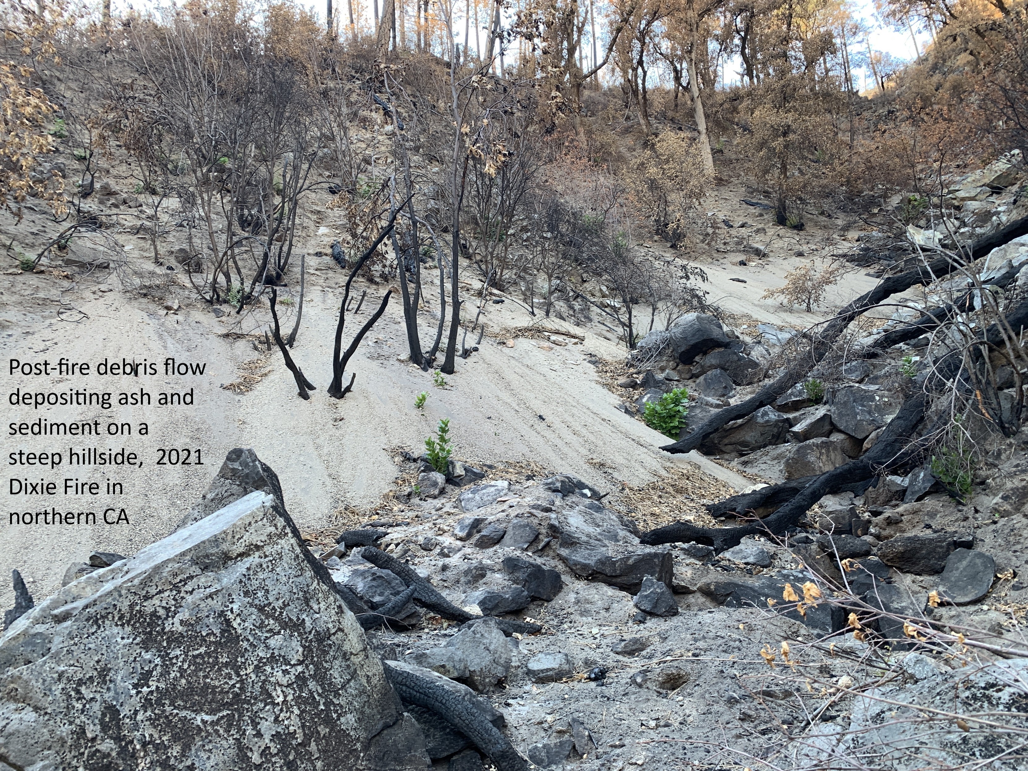
Postfire Debris-Flow Hazards
--
https://www.usgs.gov/programs/landslide-hazards/science/postfire-debris-flow-hazards <-- shared technical article / overview
--
http://alturl.com/po3yj <-- USGS Post-Fire Debris Flow Hazard Assessment Viewer
--
https://earthquake.usgs.gov/arcgis/rest/services/ls/ <-- Post-Fire Debris-Flow Hazards USGS spatial data / GIS Services
--
#GIS #spatial #mapping #USGS #LandslideHazardsProgram #NaturalHazards #3DEP #NGP #NationalGeospatialProgram #GIRT #GeospatialInformationResponseTeam #GIS #geology #hydrospatial #hydrology #landslides #debrisflows #fires #postfire #lidar #elevationdata #hazardassessments #preparedness #massmovement #engineeringgeology #risk #hazards #impacts #cost #economics #geomorphology #geomorphometry #spatialanalysis #spatiotemporal #remotesensing #soil #model #modeling #LosAngeles #LA #LosAngelesfires #California #wildfires #opendata
@USGS

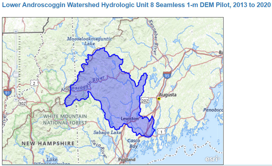
Collaboration Advances Elevation Mapping – USGS EROS And NGTOC Work Together To Map A 1 Metre Digital Elevation Model For A Watershed
--
https://www.usgs.gov/centers/eros/news/collaboration-advances-elevation-mapping <-- shared technical article
--
https://doi.org/10.5066/P1CEPE2M <-- USGS data release, Lower Androscoggin Watershed Hydrologic Unit 8 Seamless 1-m DEM Pilot, 2013 to 2020
--
#GIS #spatial #mapping #remotesensing #LiDAR #water #hydrology #3dep #3dhp #3dtnm #NGTOC #spatialanalysis #elevation #DEM #EROS #seamlessonemeter #Androscoggin #ME #maine #research #integration #watershed #opendata
@USGS | @USGS_EROS

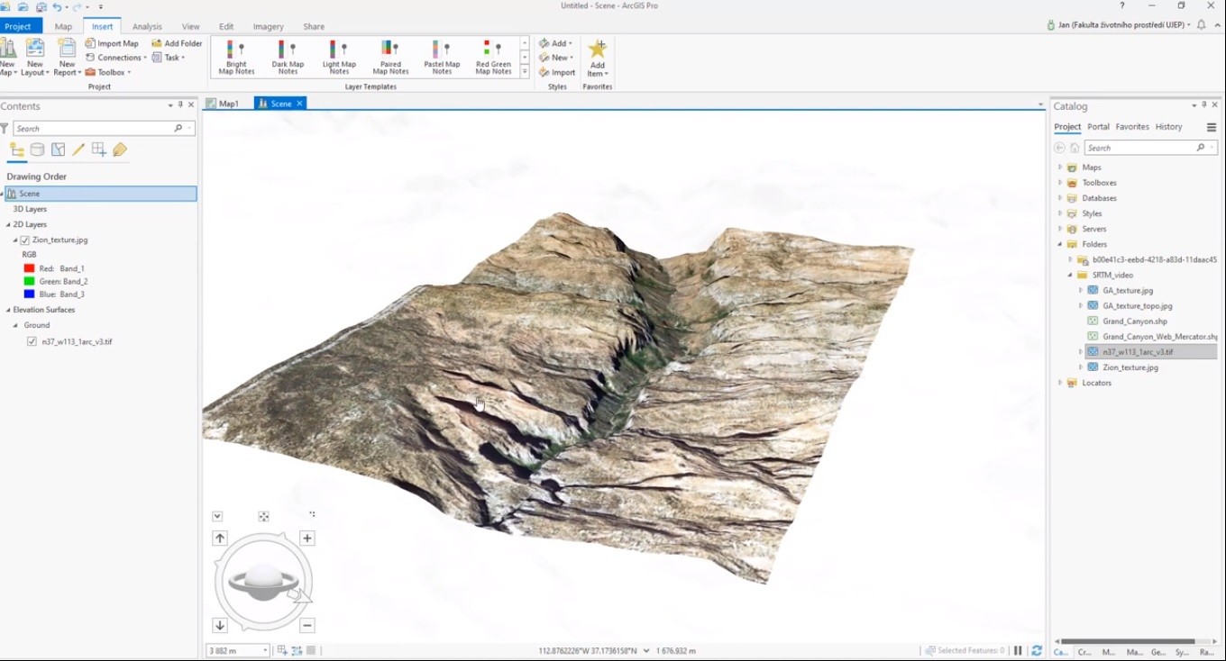
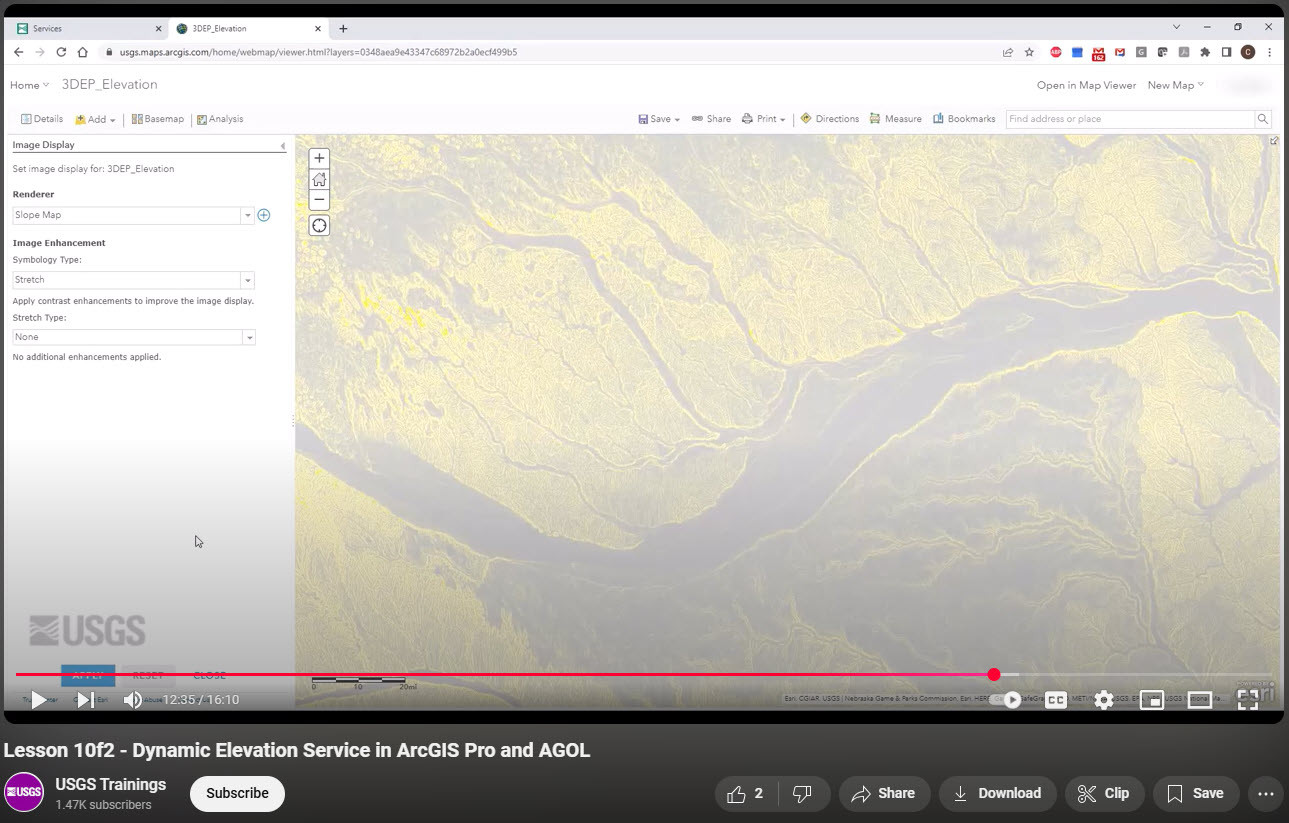
Adding 3D Elevation Program's Dynamic Elevation Web Coverage Services To ArcGIS Pro And AGOL [training video]
--
https://www.usgs.gov/ngp-user-engagement-office/news/new-training-video-dynamic-elevation-service-arcgis-pro-and-agol <-- shared technical article
--
https://youtu.be/sDEMHT2CmZw?si=u90-966VvslM6RXc <-- shared video
--
https://www.usgs.gov/3d-elevation-program/about-3dep-products-services <-- about 3DEP products & services
--
https://apps.nationalmap.gov/services/ <-- link to USGS National Map Web Services
--
#GIS #spatial #mapping #elevation #LiDAR #ifSAR #3dep #ArcGISPro #AGOL #training #video #learning #NationalMap #services #raster #topography #opendata #DynamicElevationWebCoverageService #DigitalElevationModels #DEM #DTM #onlinelearning #tutorial
@USGS

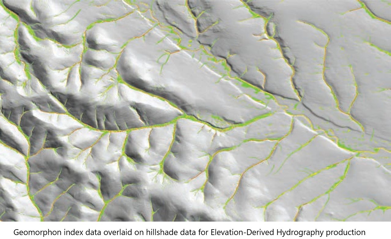
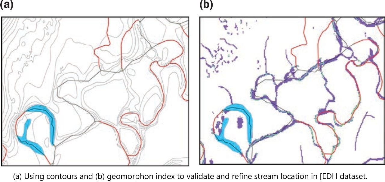
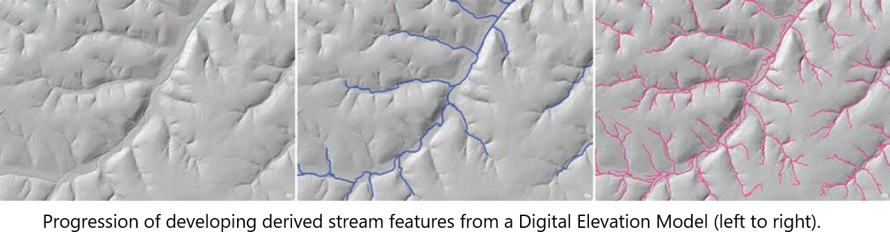
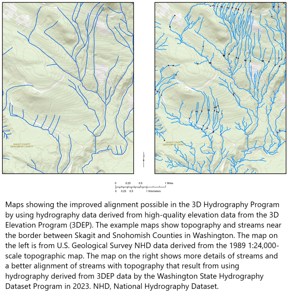
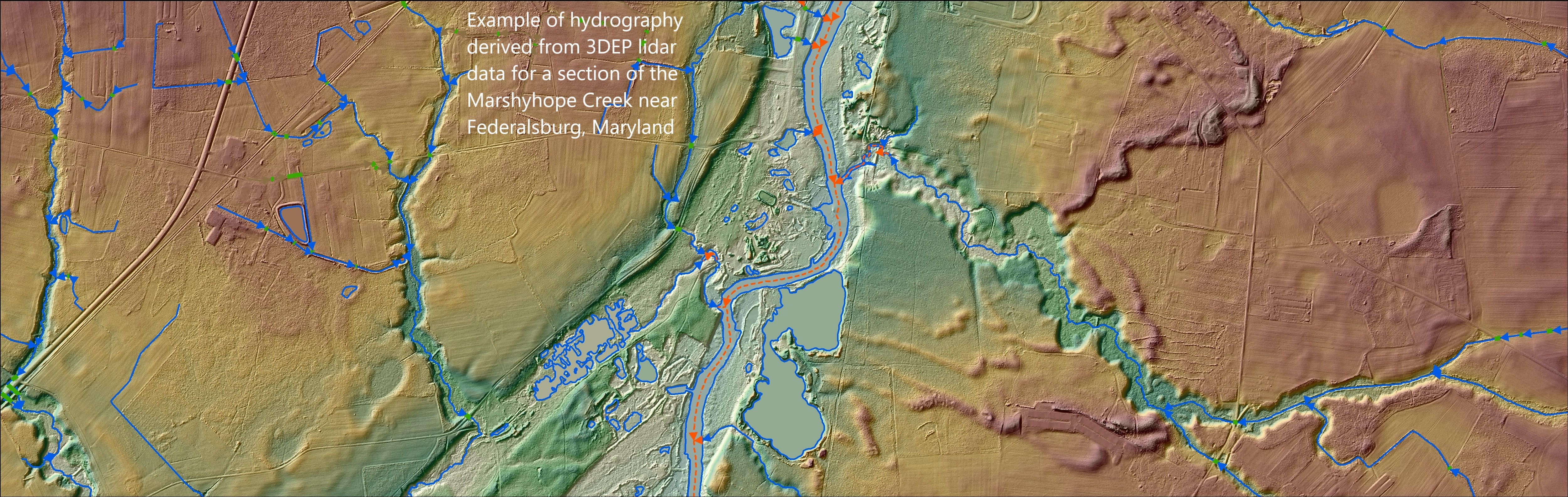
Elevation-Derived Hydrography [EDH] - The USGS’s Rich New Hydrological Features Dataset
--
https://doi.org/10.2489/jswc.2024.0314A <-- shared paper
--
https://pubs.usgs.gov/publication/tm11B12 <-- USGS EDH Representation, Extraction, Attribution, and Delineation Rules reference publication
--
https://www.usgs.gov/3d-hydrography-program <-- shared link to the USGS 3DHP page
--
[in my role, I have the pleasure of working with the valuable EDH process(es) and the data it produces on a daily basis]
#GIS #spatial #mapping #water #hydrology #hydrography #3dep #edh #3dhp #elevationderivedhydrography #opendata #elevation #dem #dtm #interpretation #waterfeatures #usecase #waterresources #floodmodeling #alignment #model #modeling #dataset #naturalresources #costs #benefits #economics #businessuse #publicdata #spatialanalysis #USA #USGS
@USGS

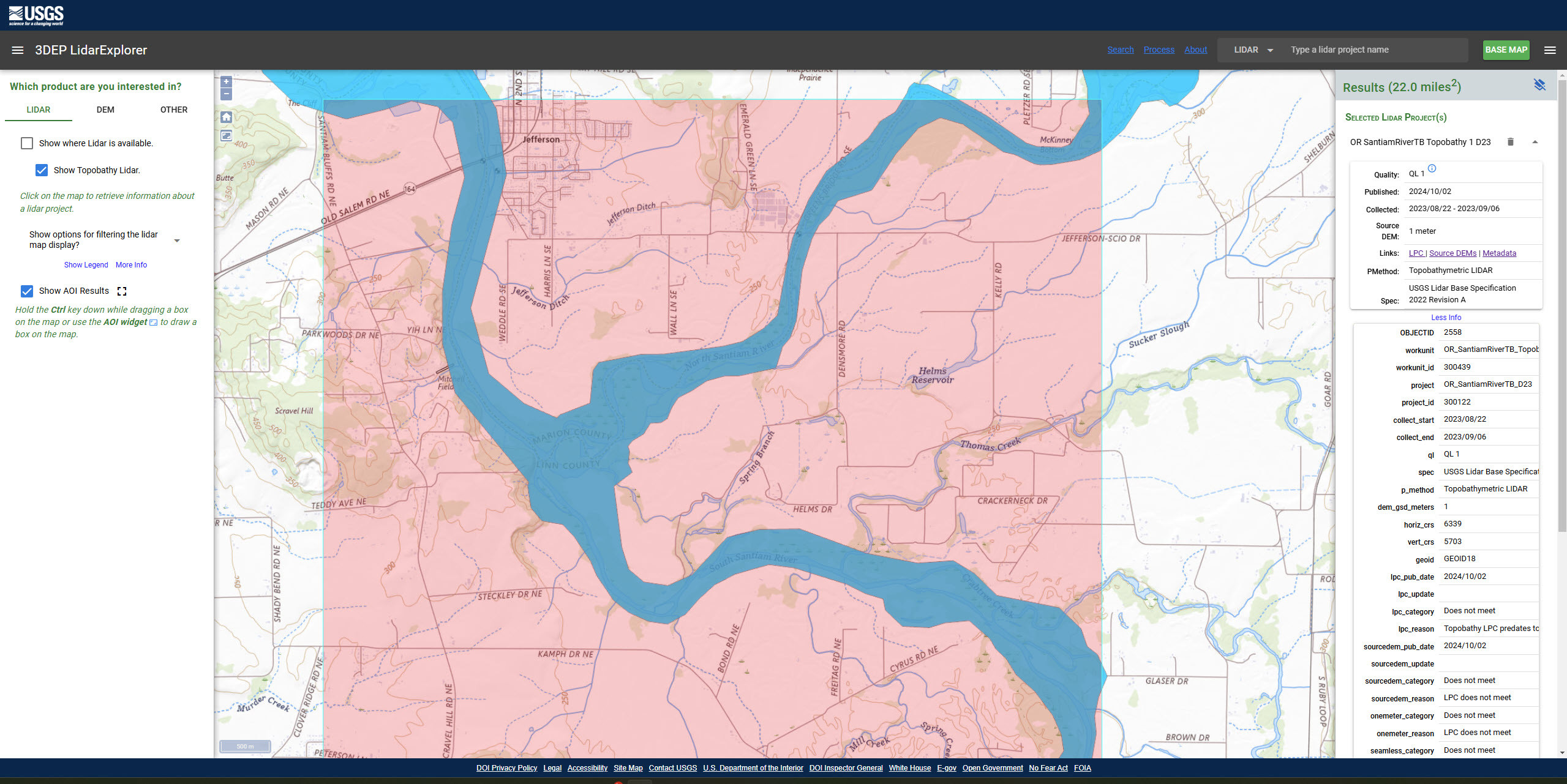
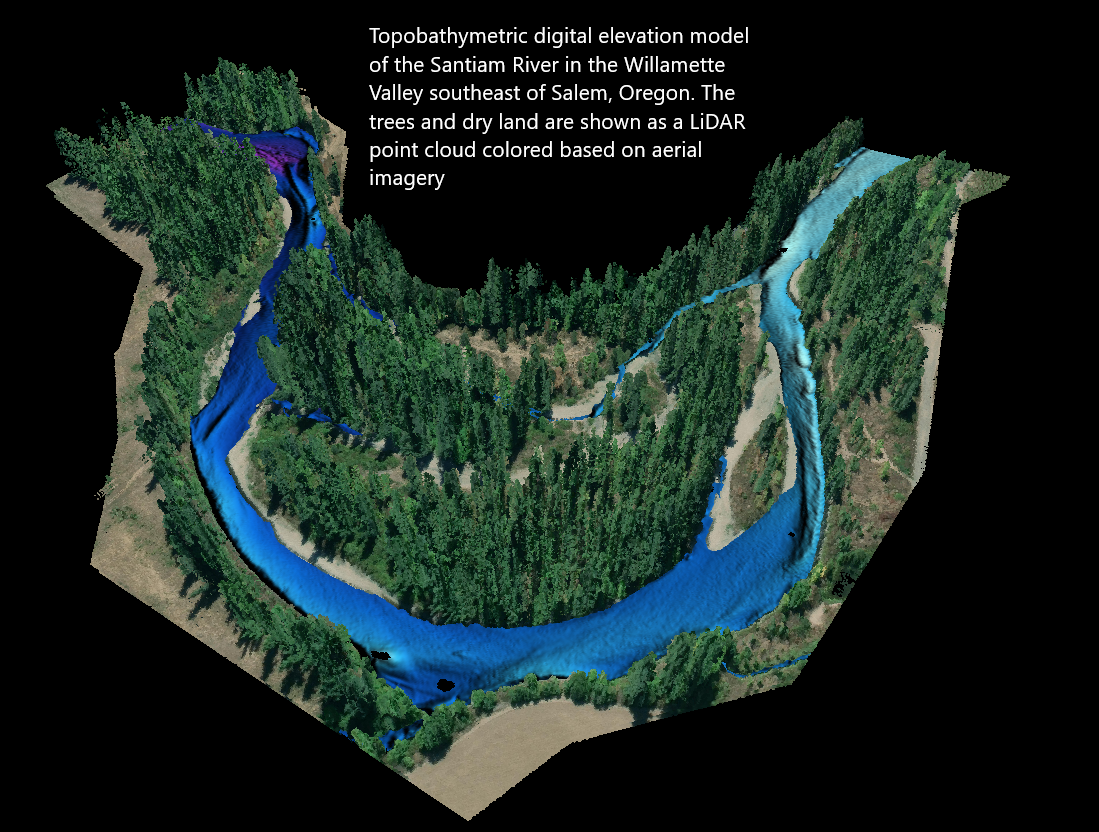
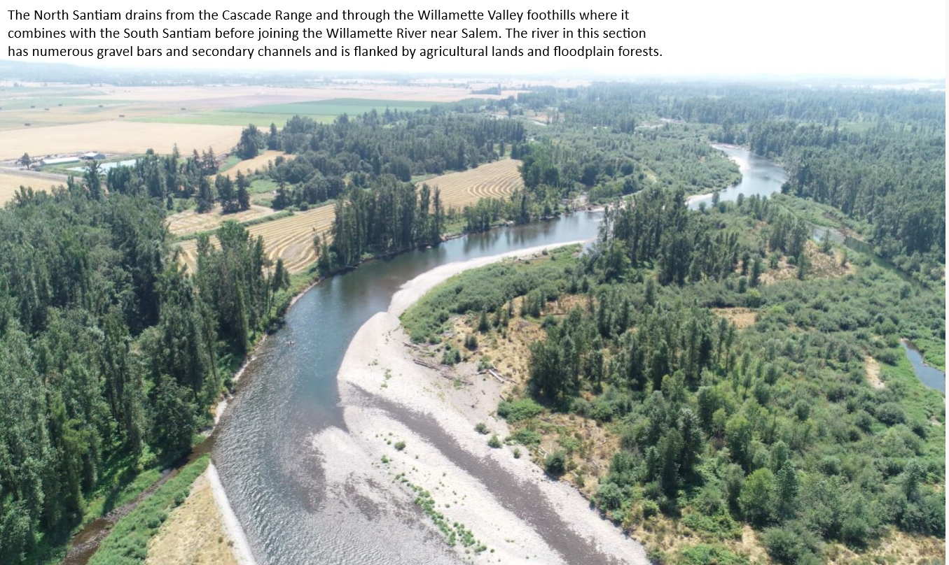
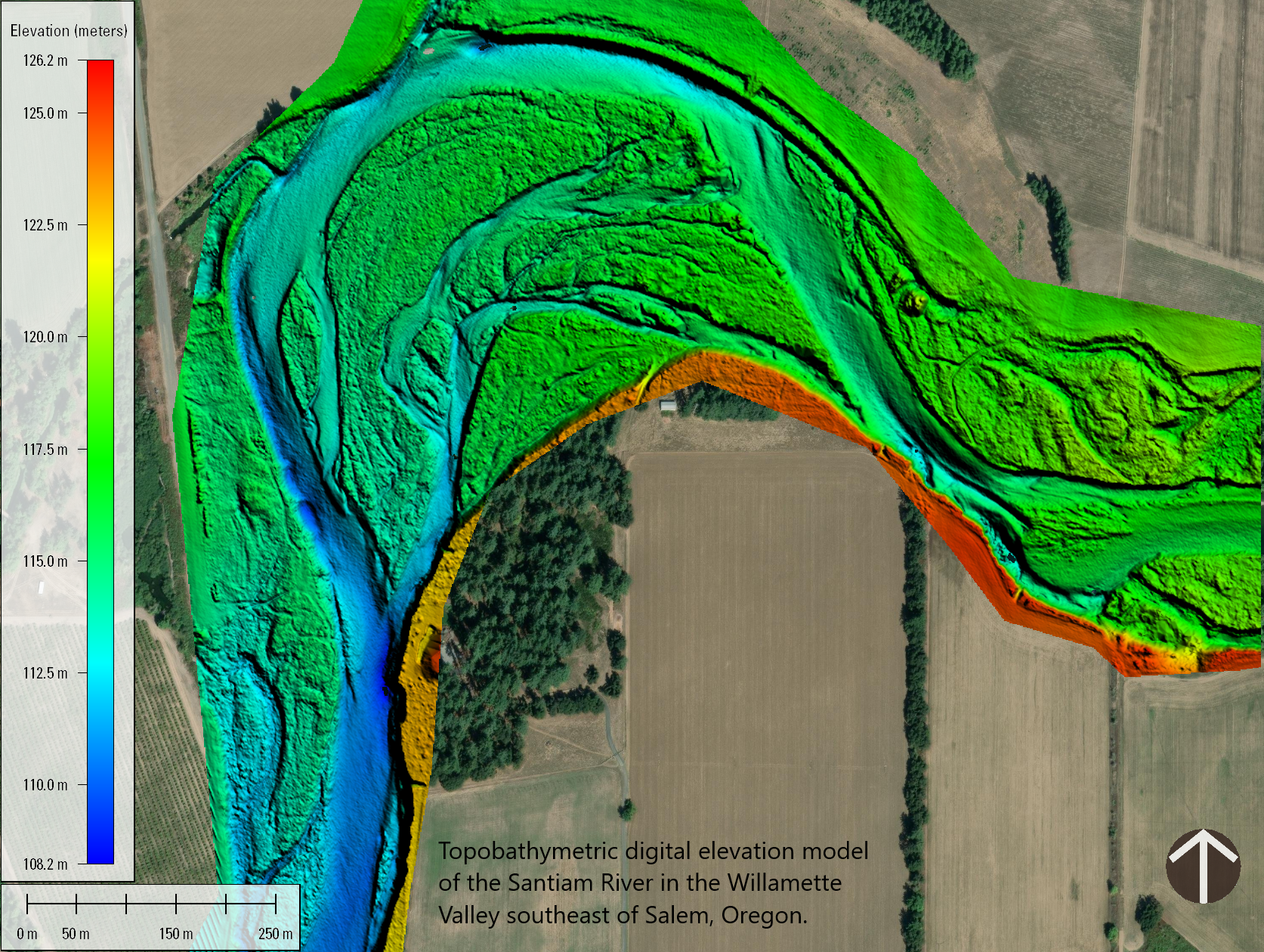
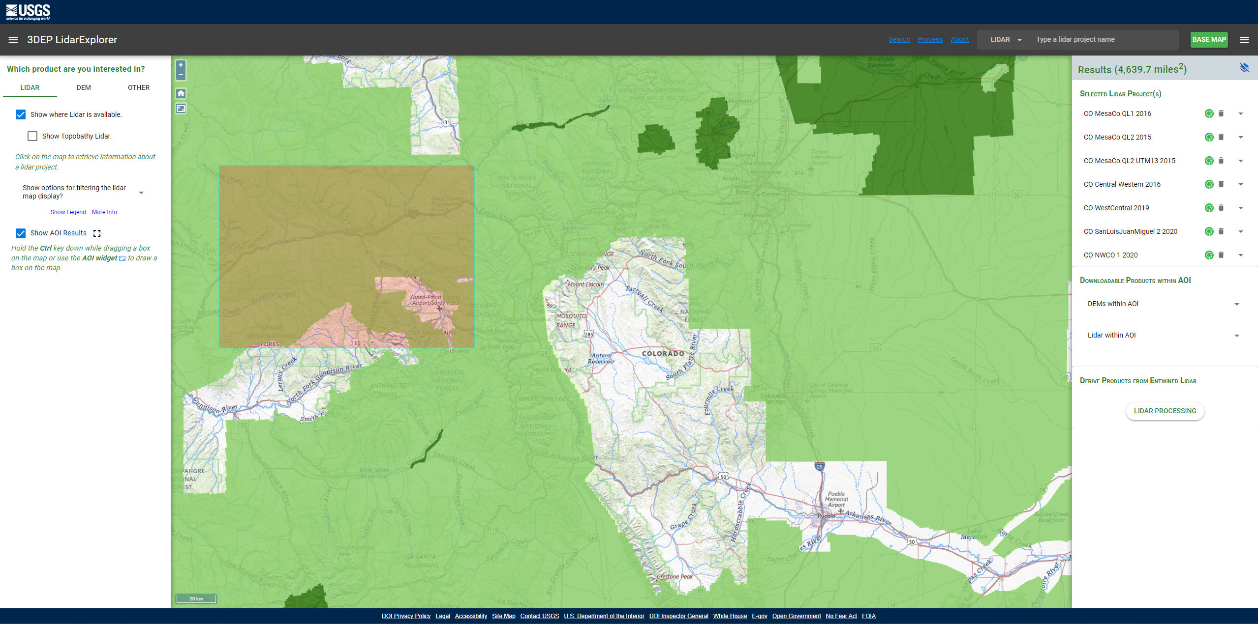
New USGS Dataset Uncovers The Santiam River’s Underwater Topography To Aid In Fish Habitat And Water Flow Management
--
https://www.usgs.gov/news/national-news-release/new-usgs-dataset-uncovers-santiam-rivers-underwater-topography-aid-fish <-- shared article
--
https://apps.nationalmap.gov/lidar-explorer/#/ <-- USGS 3DEP LiDAR Explorer (open data)
--
#GIS #spatial #mapping #remotesensing #LiDAR #topobathymetry #topobathy #example #usecase #wildfires #rivermanagement #climatechange #waterresources #SantiamRiver #Oregon #KlamathRiver #PotomacRiver #ColoradoRiver #USGS #USACE #3DEP #opendata #topography #elevation #3DTNM #water #hydrology #hydrospatial #pilotproject #prototype #infrastructure #navigation #engineering #riverbed #sediment #sedimentation #habitat #river #waterbody #flowmanagement #dams #salmon #steelhead #fish #WillametteValley #flood #flooding #risk #hazard #model #modeling #FIM #watersupply #agriculture
@USGS @USACE
Getting Started On Diagramming This Project’s Workflow, ‘Old School’
--
Couple of 10s of pages of data inventory, roles and responsibilities, even the start of a RACI, pot of good black tea – now time to get started on diagramming this project’s workflow, components, interim data products, R&R, development and more #oldschoool, ready for full team involvement – ‘helpers’ notwithstanding!
#GIS #spatial #mapping #opendata #water #hydrology #3dep #edh #3dhp #datadelivery #3dhedit #3dtnm #rolesandresponsibilities #RACI #5W1H #workflow #planning #pm #projectmanagement #integration
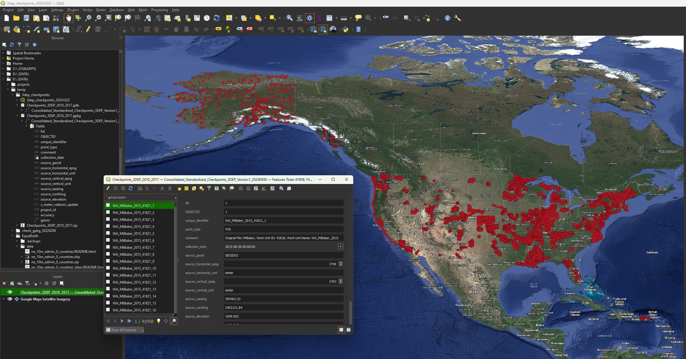
Consolidated Standardized Survey-Grade Checkpoints 3DEP 2010 to 2017 [USGS]
--
https://www.sciencebase.gov/catalog/item/67075e6bd34e969edc59c3e7
--
“One of the key aspects of 3DEP data is that data is verified by a collection of certified survey-grade GNSS checkpoints spread throughout each project. These points have always been available but were difficult to find and not standardized. [The USGS] have collated and standardized almost 42,000 of these checkpoints and are making them available for other uses. These points here in this first phase span from 2010-2017, but [the USGS] are in the process of making these available for all [their] projects, and hope to enable them in different ways in the future...”
#GIS #spatial #mapping #USGS #USA #elevation #opendata #remotesensing #LiDAR #ifSAR #3dep #3dhp #water #hydrology #3d #opendata #3dtnm #checkpoint #checkpointdigital #GNS #GPS #NGD #DEM #survey #surveygrade #accuracy #precision #calibration #digital #NGTOC #NAD83
@USGS
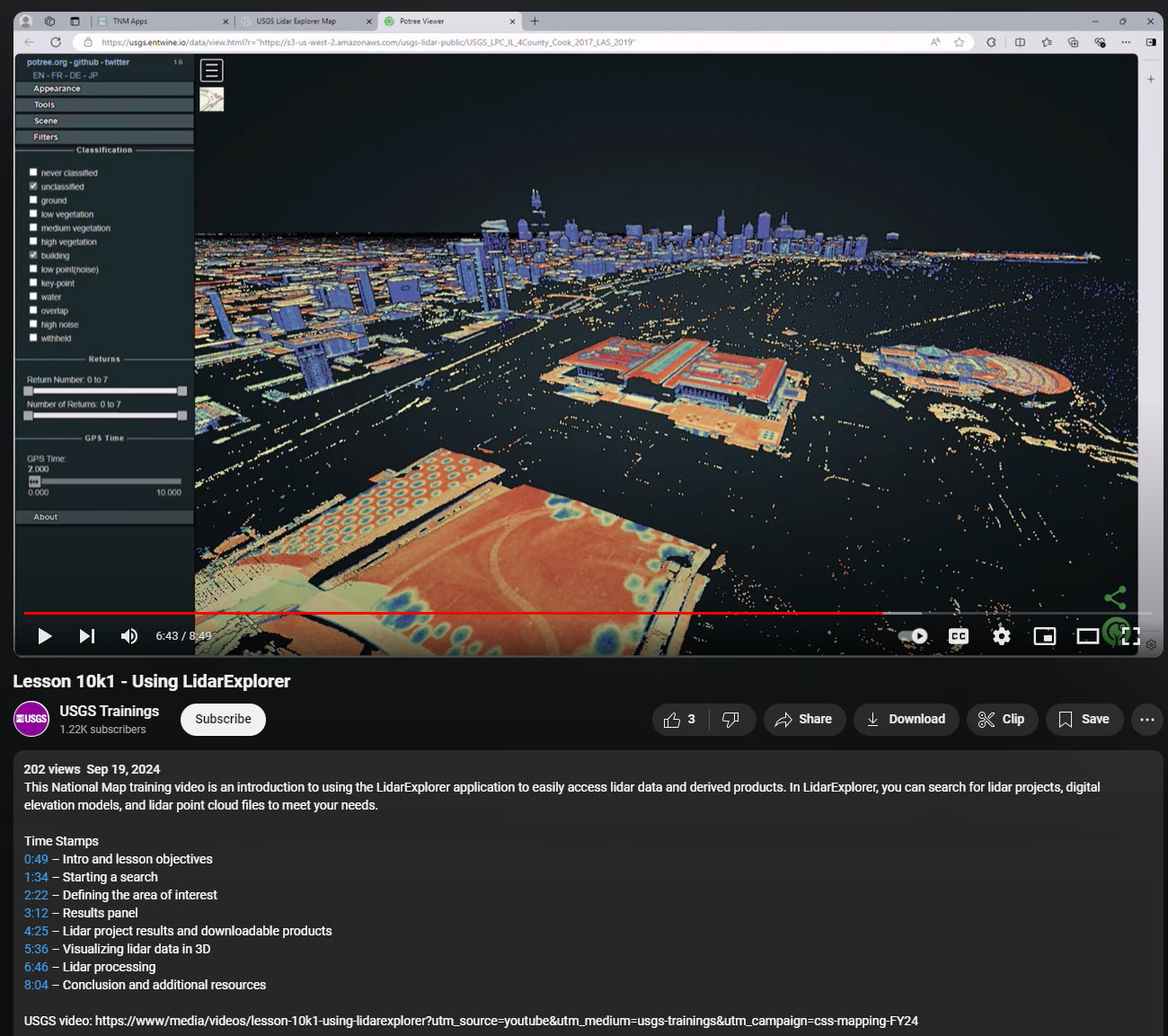
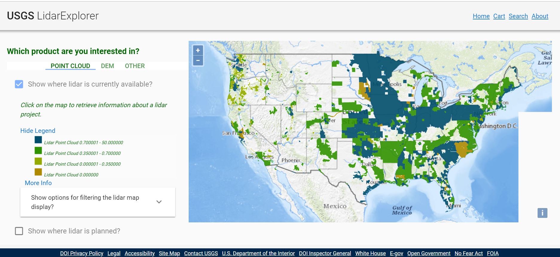
Lesson 10k1 - Using LiDARExplorer [USGS National Map training video]
--
https://youtu.be/36cfnwFWzj4?si=Ne5uk_jjbAjIaSGE <-- shared technical tutorial video
--
https://apps.nationalmap.gov/lidar-explorer/#/ <-- link to USGS app
--
https://www.usgs.gov/3d-elevation-program <-- USGS 3DEP home page
--
“This [USGS] National Map training video is an introduction to using the LidarExplorer application to easily access lidar data and derived products. In LidarExplorer, you can search for lidar projects, digital elevation models, and lidar point cloud files to meet your needs…”
#GIS #spatial #mapping #remotesensing #LiDAR #LidarExplorer #app #webmap #data #opendata #NationalMap #training #video #tutorial #selfhelp #onlinelearning #3dep #US #USA #DEM #elevation
@USGS
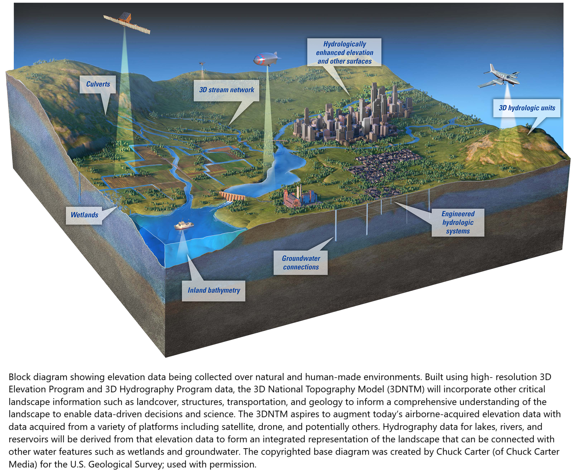
USGS Releases ‘The 3D National Topography Model [3DTNM] Call For Action - Part 1: The 3D Hydrography Program [3DHP]’
--
https://www.usgs.gov/news/technical-announcement/now-available-usgs-releases-3d-national-topography-model-call-action <-- technical announcement
--
https://pubs.usgs.gov/publication/cir1519 <-- USGS Circular 1519 publication link
--
https://www.usgs.gov/3DHP <-- shared USGS 3DHP home page
--
https://internetofwater.org/ <-- shared Internet of Water home page
--
[ nice to see this, although I am maybe biased ~wink~ ]
#GIS #spatial #mapping #water #hydrology #surfacewater #3D #opendata #3DHP #3DEP #EDH #3DTNM #elevationderivedhydrology #topography #hydrography #CallForAction #publicdata #HYFeatures #opensource #IOW #InternetOfWater #DEMs #digitalinfrastructure #waterresources #resourcemanagement #inventory #planning
@USGS
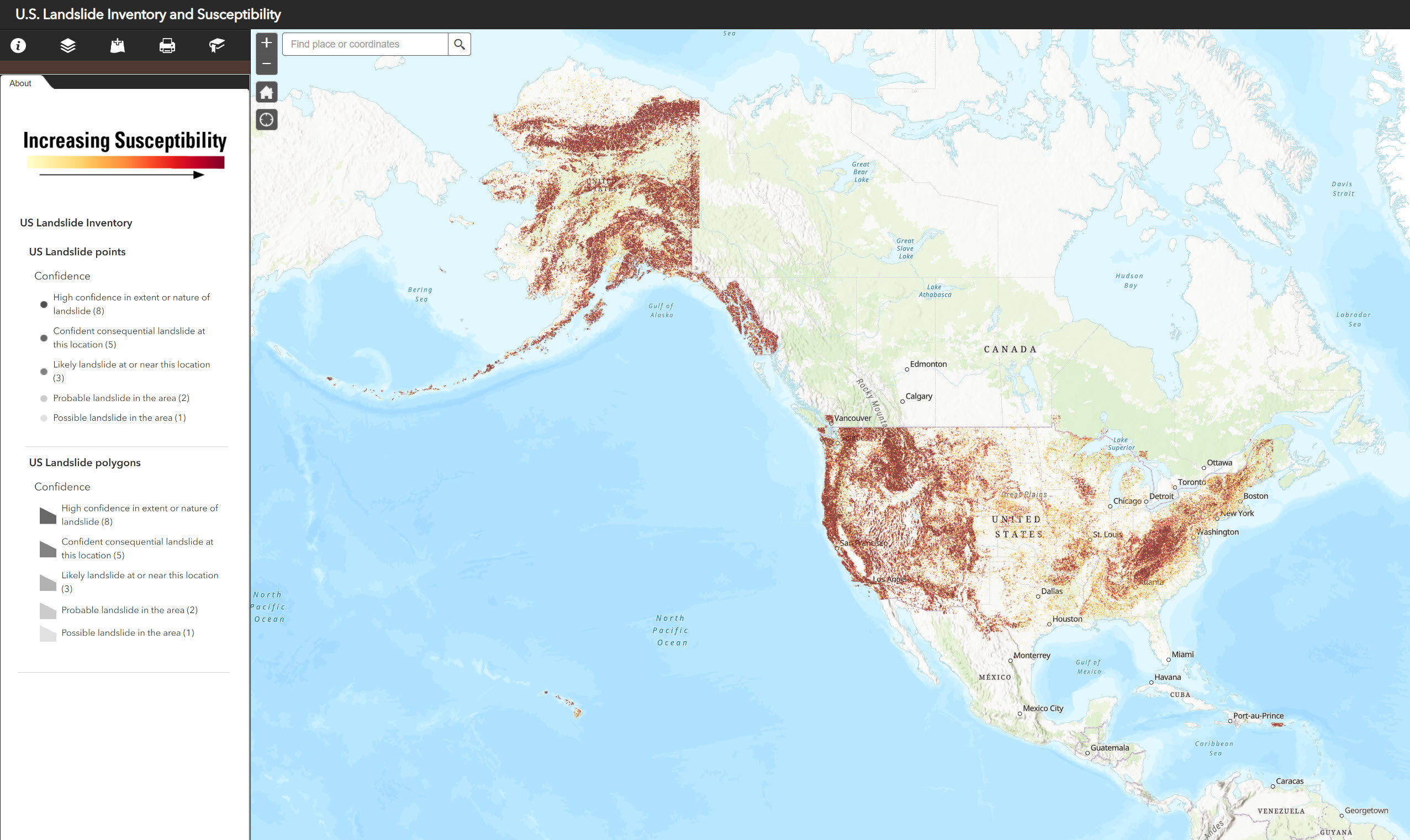
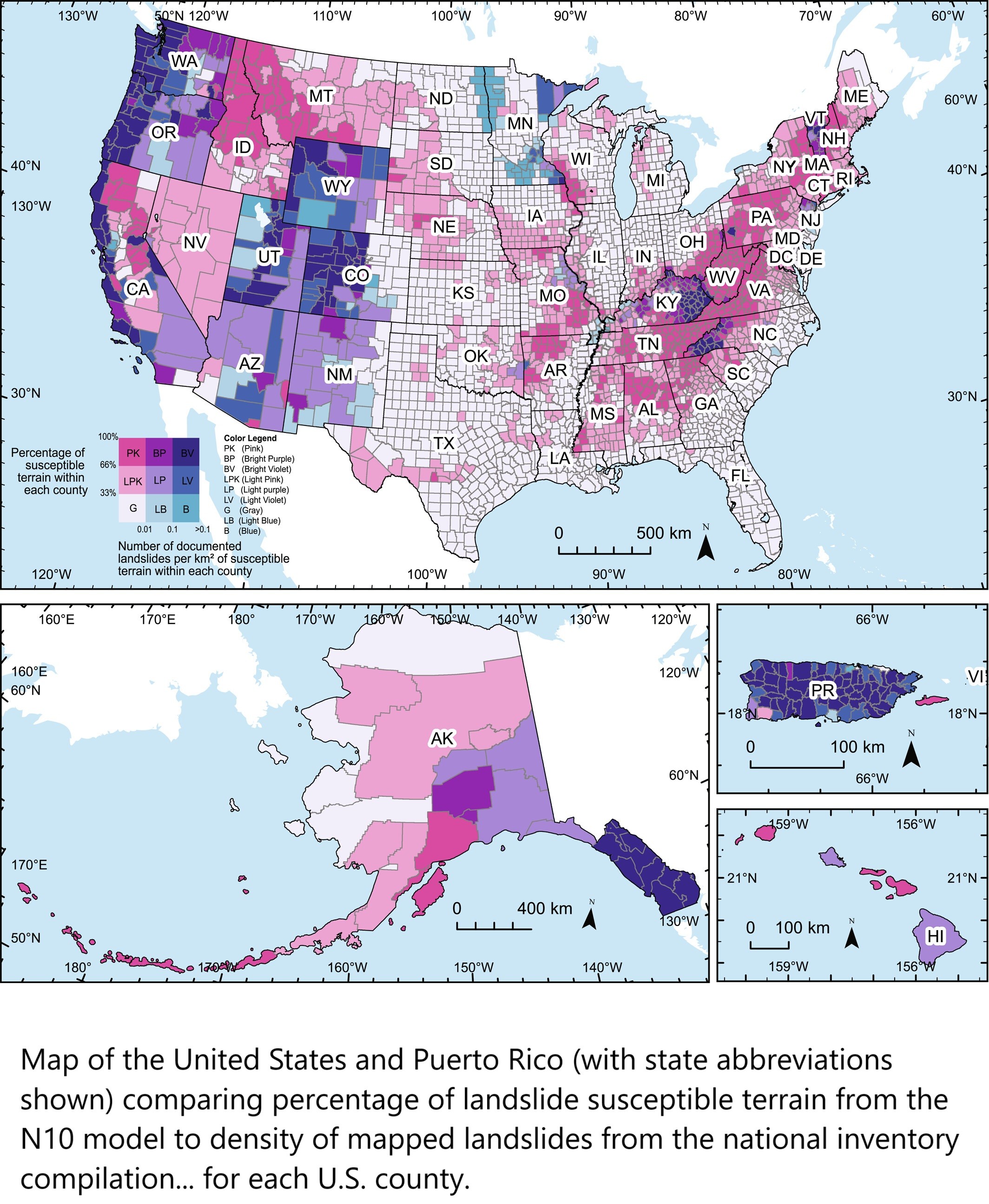
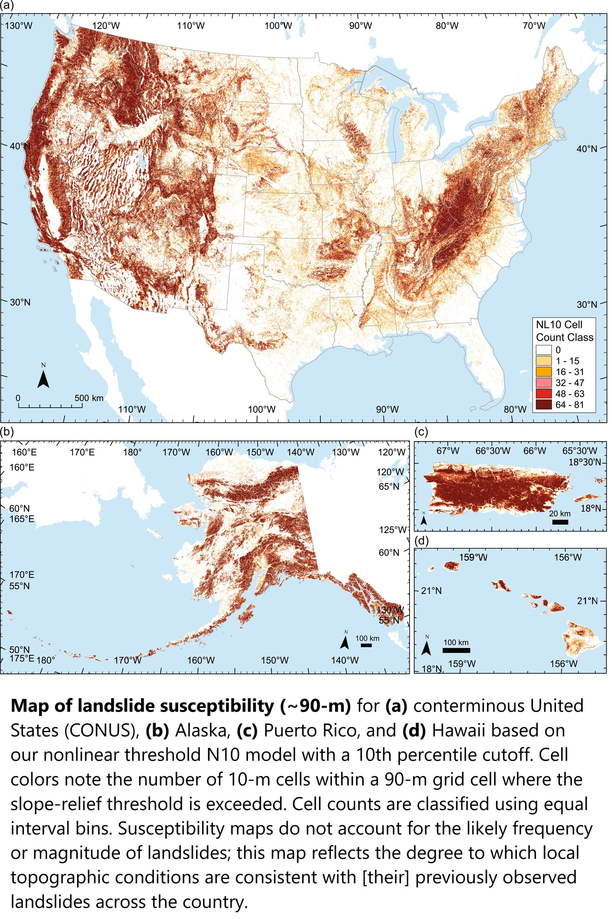
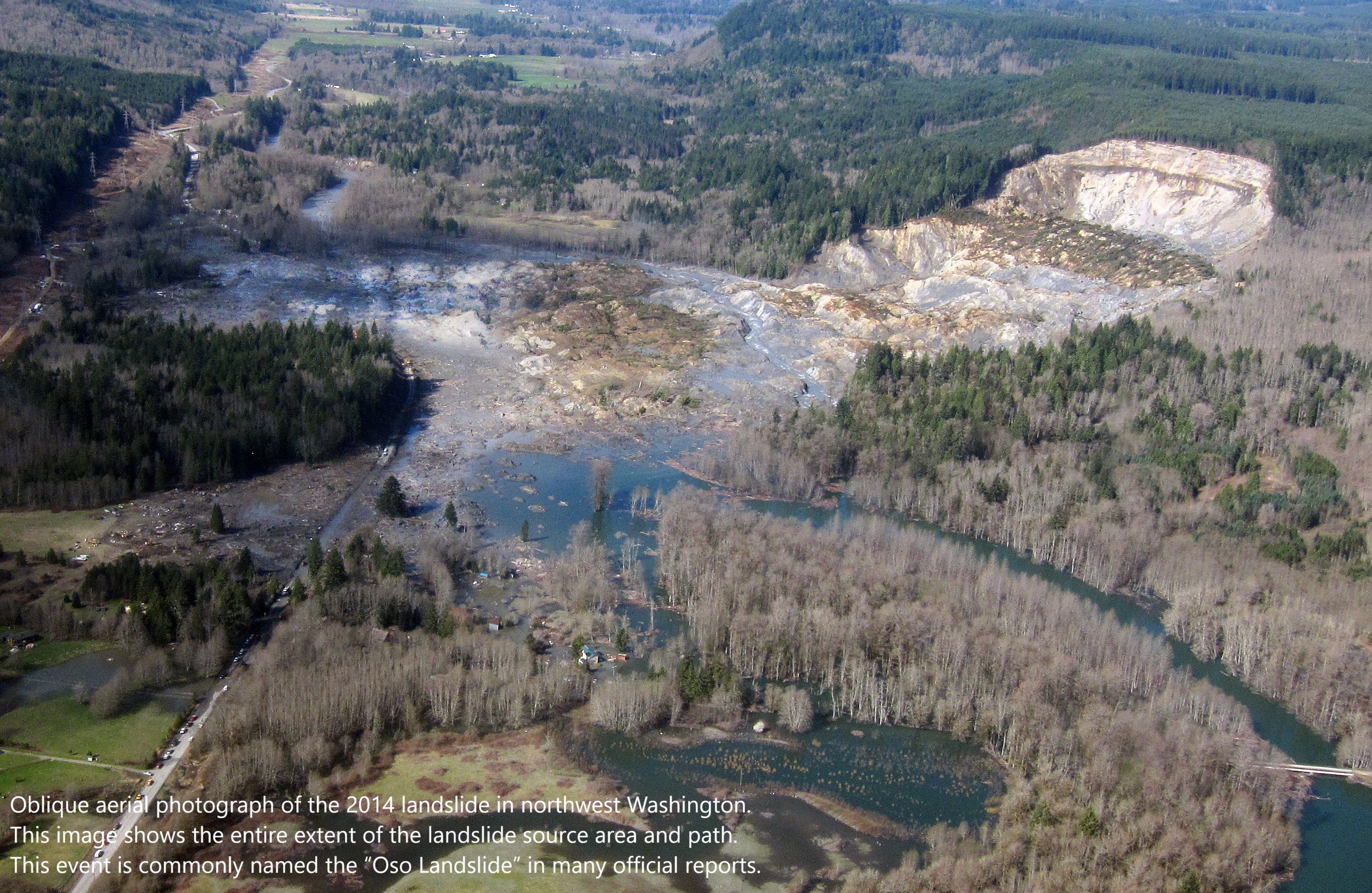
U.S. Landslide Inventory and Susceptibility Map [updated, USGS]
--
https://www.usgs.gov/tools/us-landslide-inventory-and-susceptibility-map <-- shared technical resource, with map and county-level metrics are available as structured data
--
http://alturl.com/ztxbs <-- shared link to USGS Landslide Susceptibility WebMap
--
https://www.usgs.gov/media/videos/parsimonious-landslide-susceptibility-modeling-continental-scales-a-new-high <-- shared video overview
--
https://doi.org/10.1029/2024AV001214 <-- shared paper
--
https://doi.org/10.5066/P13KAGU3 <-- shared 2024 USGS technical publication
--
#GIS #spatial #mapping #model #modeling #spatialanalysis #geology #engineeringgeology #massmovement #landslide #spatialanalysis #historicdata #webmap #USA #3dep #elevation #topography #geomorphometry #geomorphology #risk #hazard #riskreduction #suspectibility #opendata #remotesensing #database #compilation #inventory #terrain #landuse #planning
@USGS
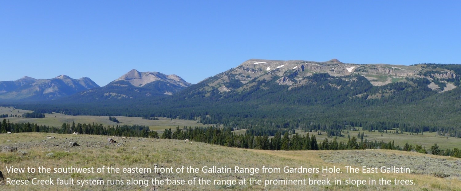
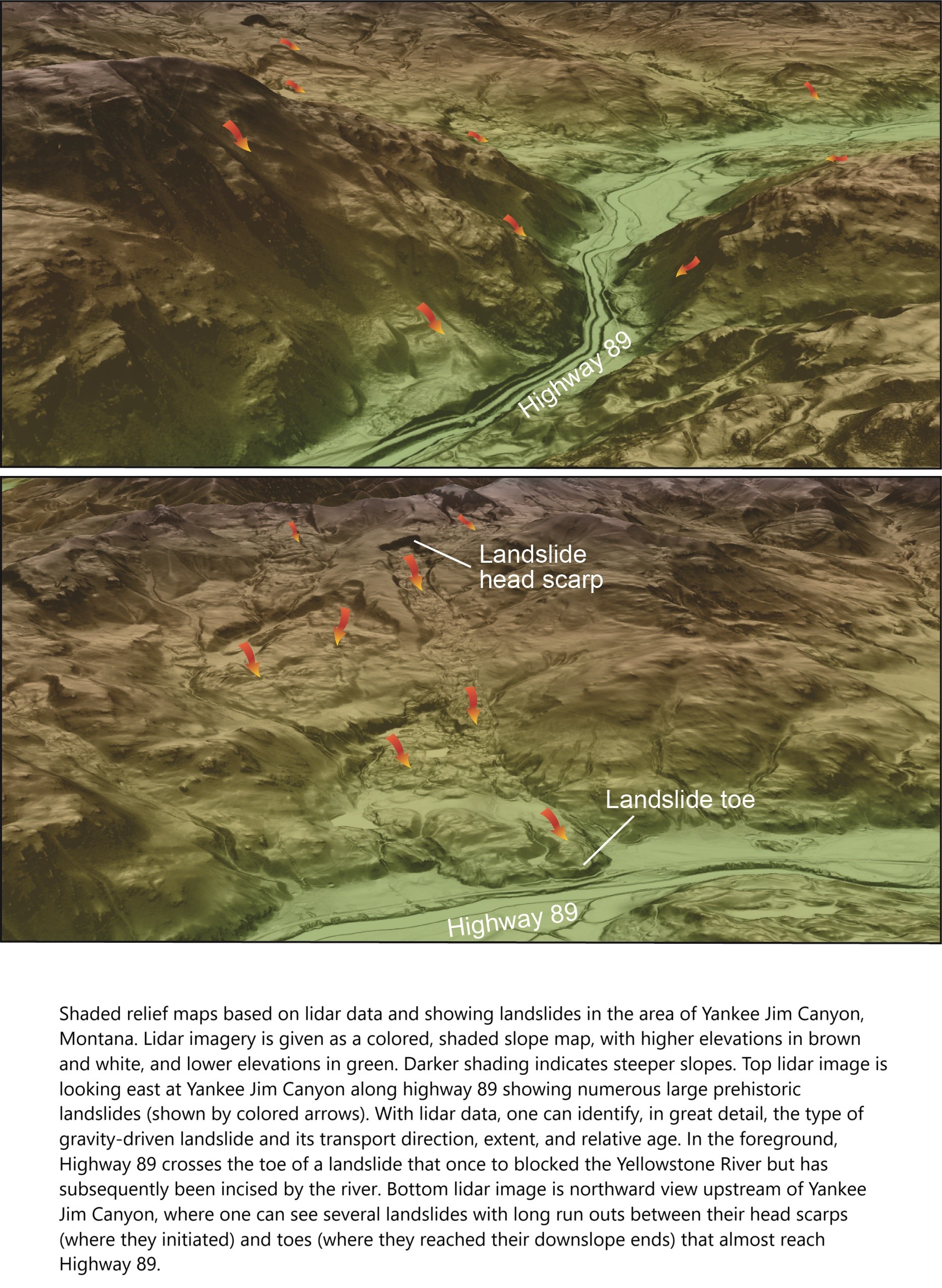
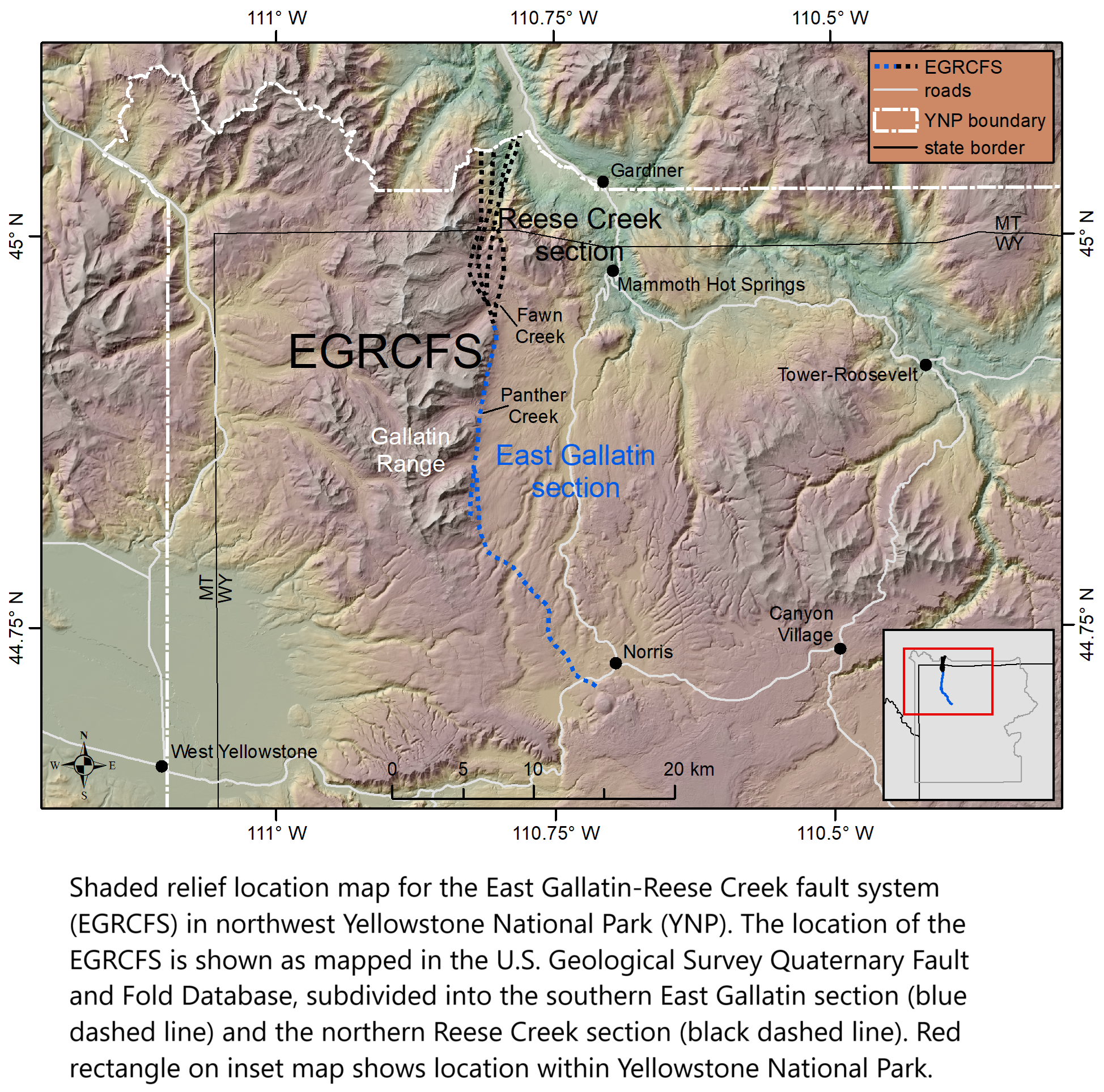
New Study Seeks To Shed Light On Earthquake Hazards In The Gallatin Range
--
https://www.usgs.gov/observatories/yvo/news/new-study-seeks-shed-light-earthquake-hazards-gallatin-range <-- shared technical article
--
#GIS #spatial #mapping #remotesensing #LiDAR #earthquake #fault #scarps #faulting #opendata #3dep #NGTOC #ruptures #surfaceexpression #risk #hazard #geology #engineeringgeology #geomorphology #geomorphmetry #seismology #elevation #topography #EastGallatin #ReeseCreek #faultsystem #EGRCFS #GallatinRange #GardnersHole #Yellowstone #Wyoming #Montana #USA #glaciation #superposition #dating #geologichistory #NationalSeismicHazardModel #model #modeling #spatialanalysis #spatiotemporal #massmovement #hydrothermal #YellowstoneNationalPark
@USGS

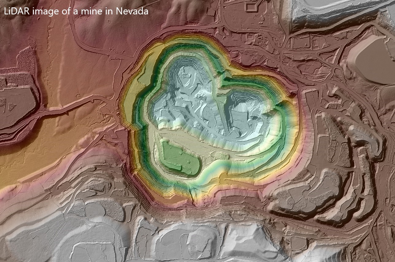
3D Elevation [3DEP] Data Crucial To Supporting The Nation’s Infrastructure And Maintaining Economic Security
--
https://www.usgs.gov/news/featured-story/3d-elevation-data-crucial-supporting-nations-infrastructure-and-maintaining <-- link to article
--
https://www.usgs.gov/3d-elevation-program <-- USGS 3DEP home page and access to open data
--
https://www.usgs.gov/3d-national-topography-model/fy24-3dep-data-collaboration-announcement-dca-selected-projects <-- 3DEP Data Collaboration Selected Projects
--
#GIS #spatial #mapping #LiDAR #opendata #USA #elevation #remotesensing #3DEP #topography #economy #economicbenefits #economicsecurity #infrastructure #national #3d #pointcloud #usecase #appliedscience #business #construction #IfSAR #bareearth #datacollaboration
@USGS

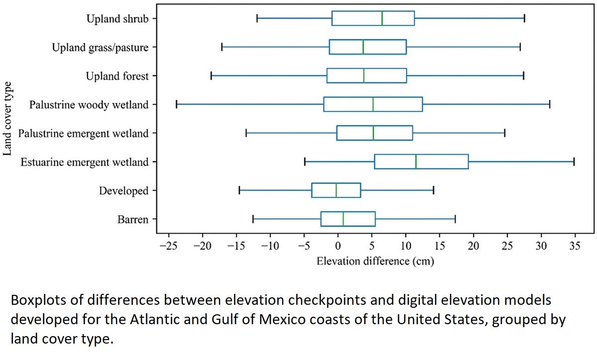
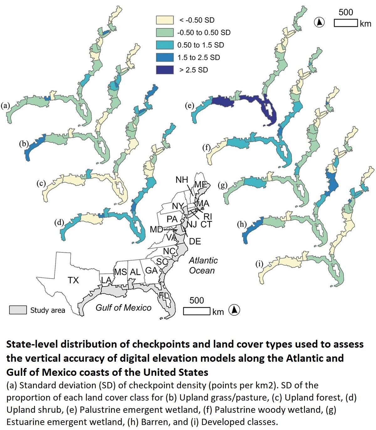
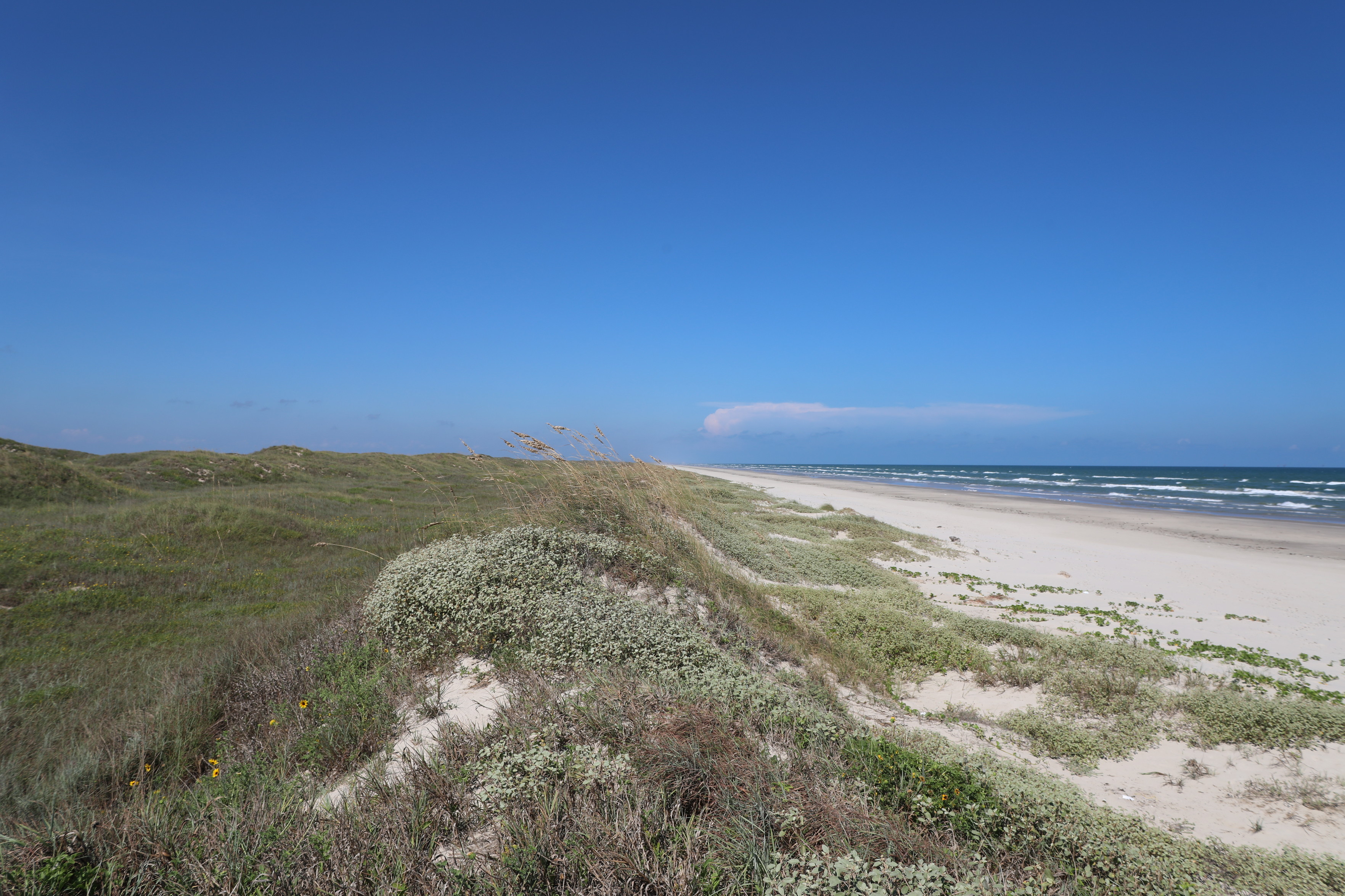
Assessing The Vertical Accuracy Of Digital Elevation Models By Quality Level And Land Cover
--
https://doi.org/10.1080/2150704X.2024.2368924 <-- shared paper
--
#GIS #spatial #mapping #USGS #3dep #elevation #LiDAR #vertical #accuracy #precision #risk #hazard #coast #coastal #landcover #landuse #flood #flooding #stormsurge #geostatistics #spatialstatistics
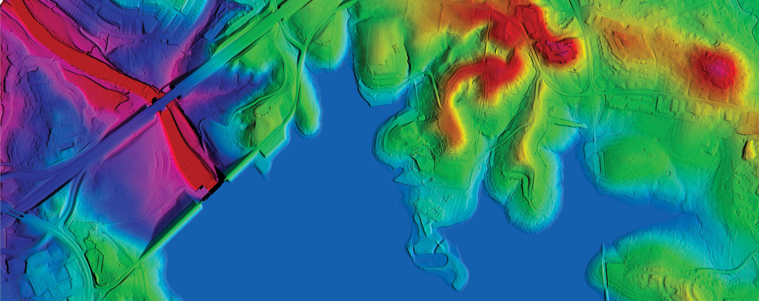
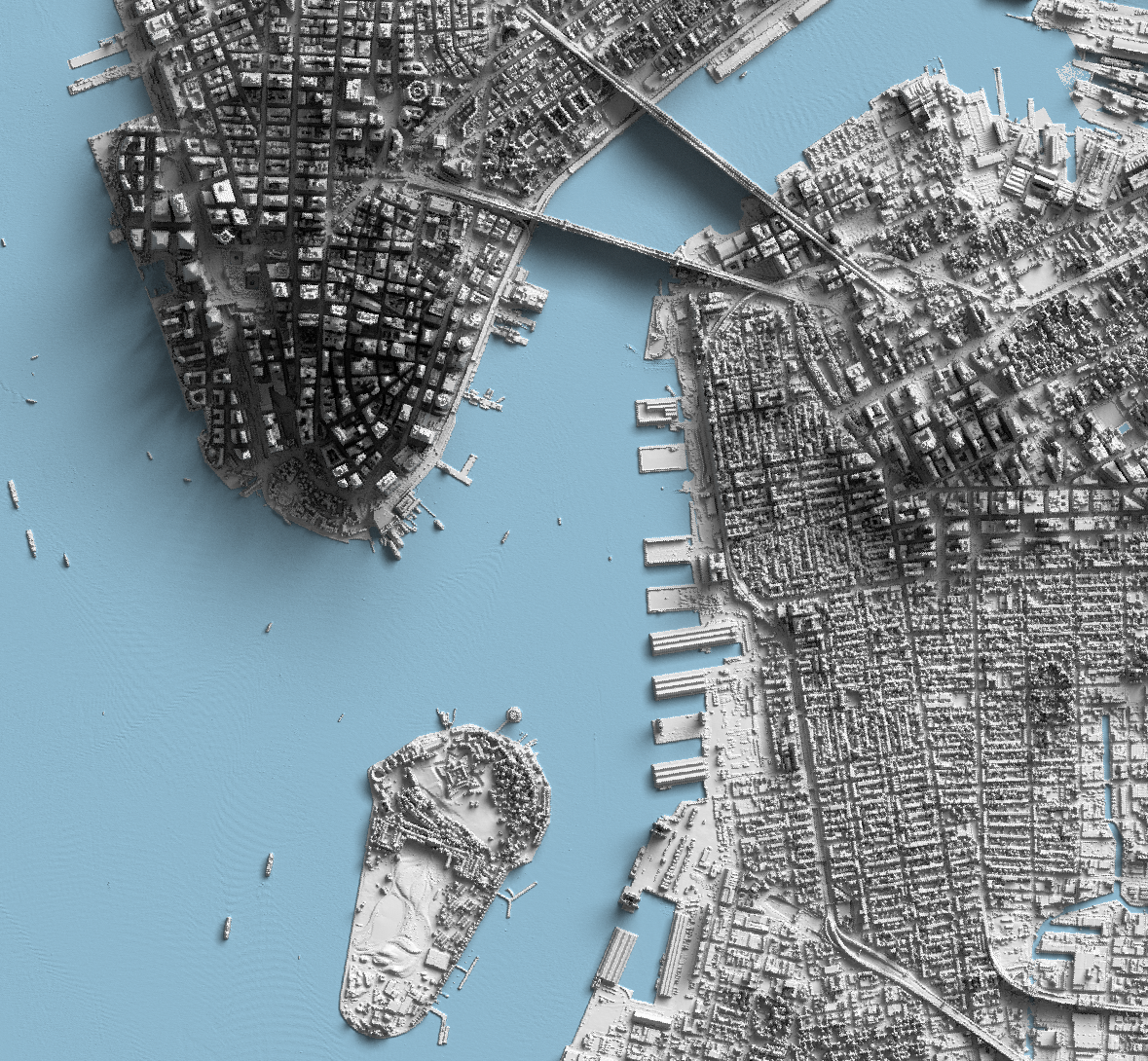
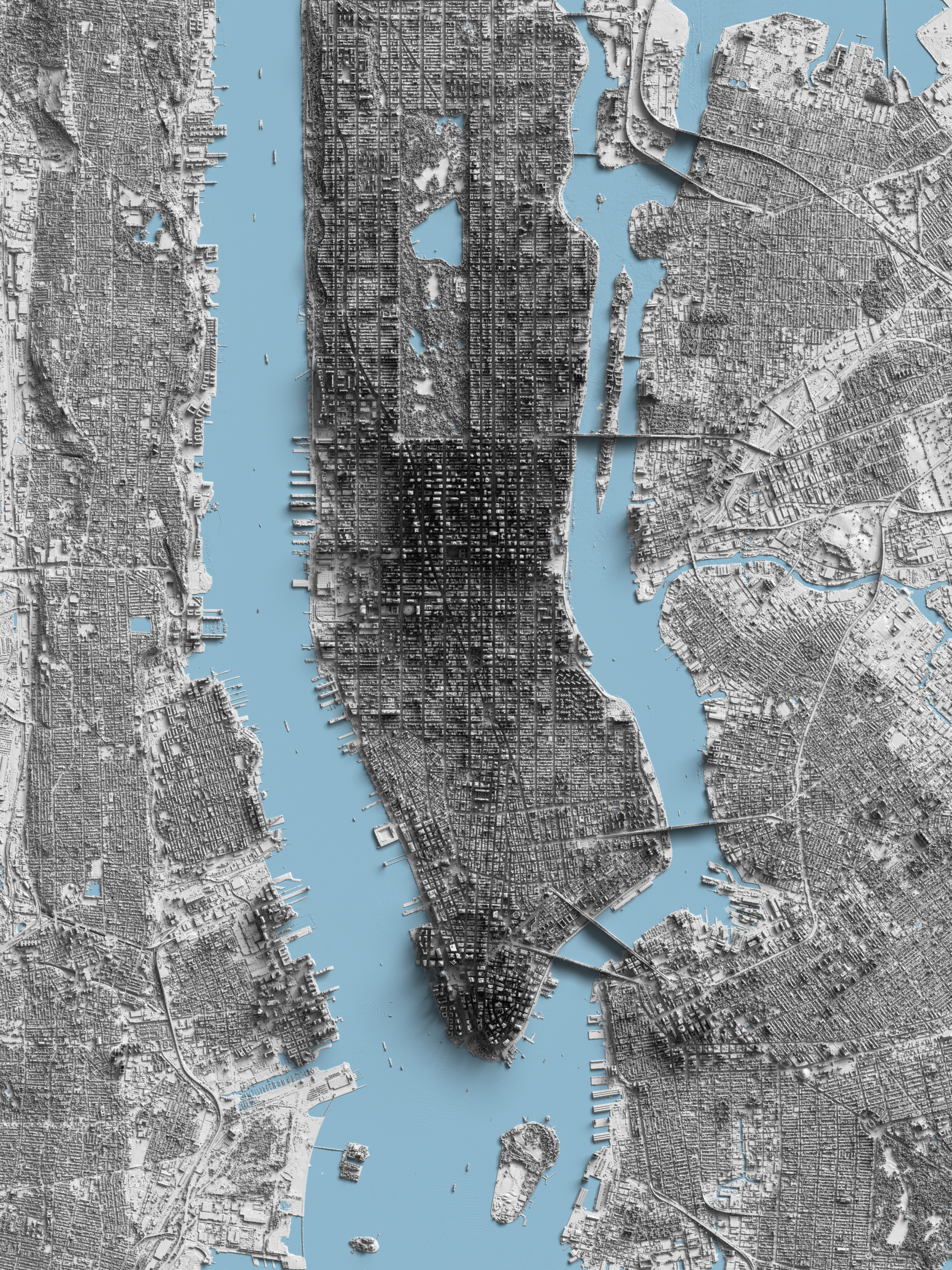
Shaded Relief Map Of Manhattan, New York - Made From USGS LiDAR Data
--
https://visualwallmaps.com/ <-- link to the cartographer’s commercial page [not considered an endorsement]
--
https://www.usgs.gov/3d-elevation-program <-- access to 3DEP open data USA elevation datasets via the USGS
--
#GIS #spatial #mapping #DEM #3dep #elevation #LiDAR #cartography #opendata #USGS #USA #shadedrelief #representation #visualisation #Manhattan #NewYork #NYC #NewYorkCity #mapmaking #3d #3drendering
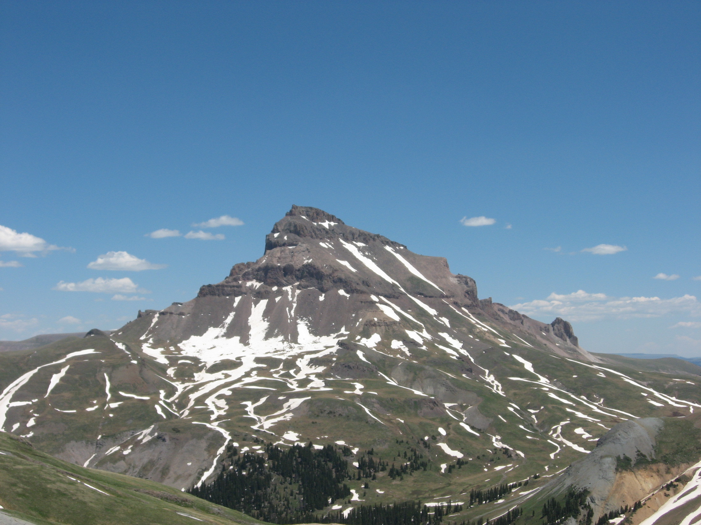
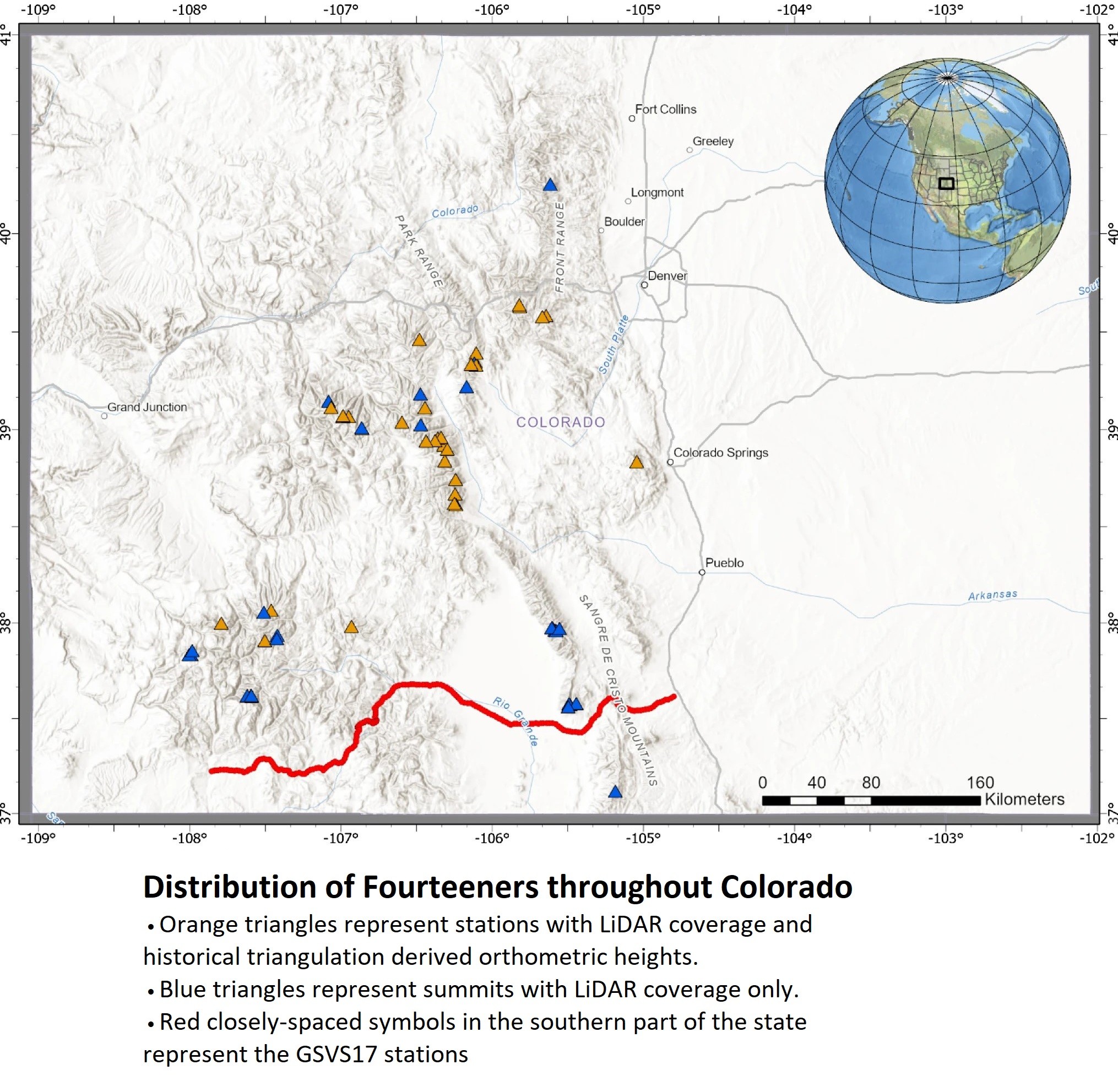
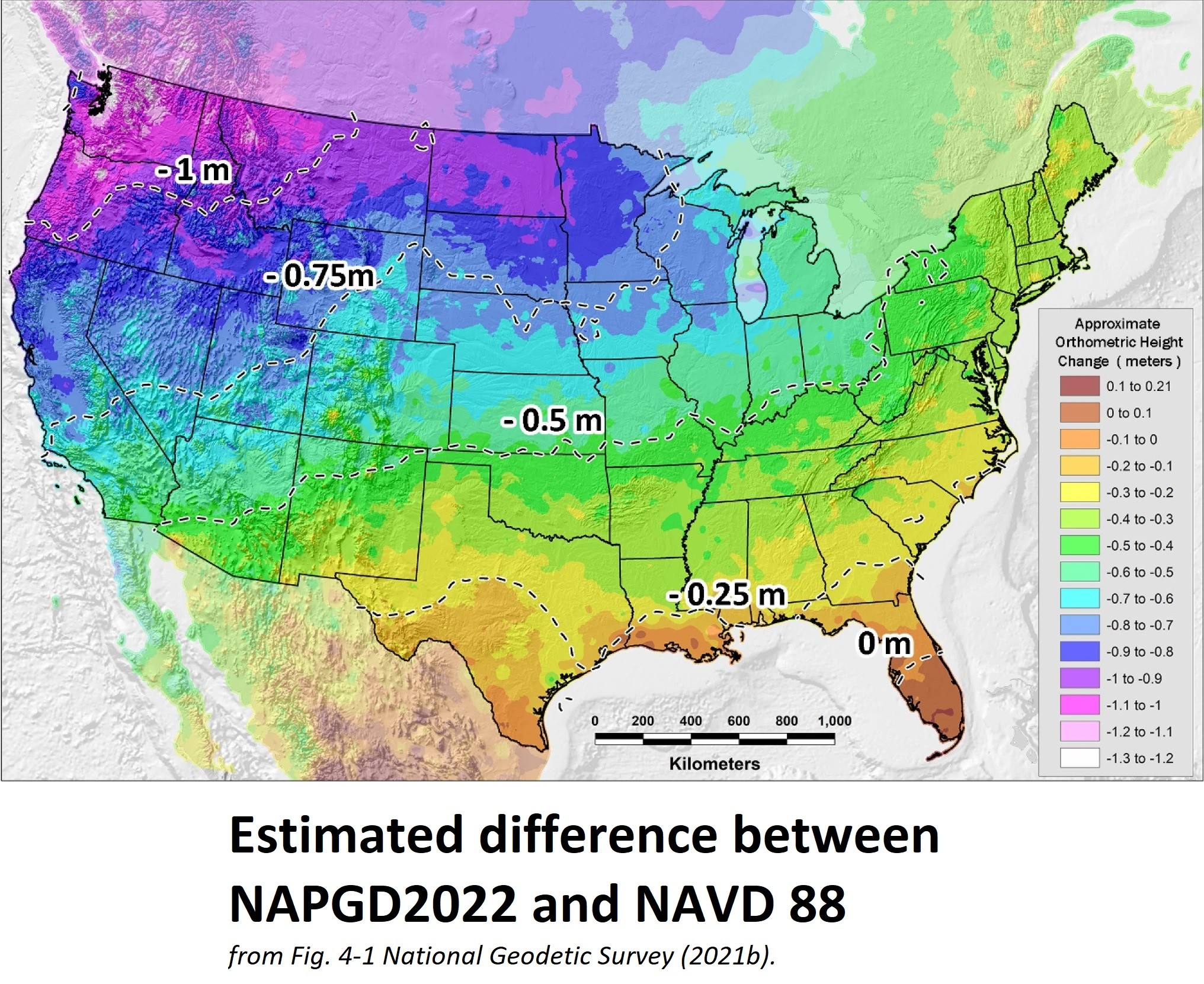
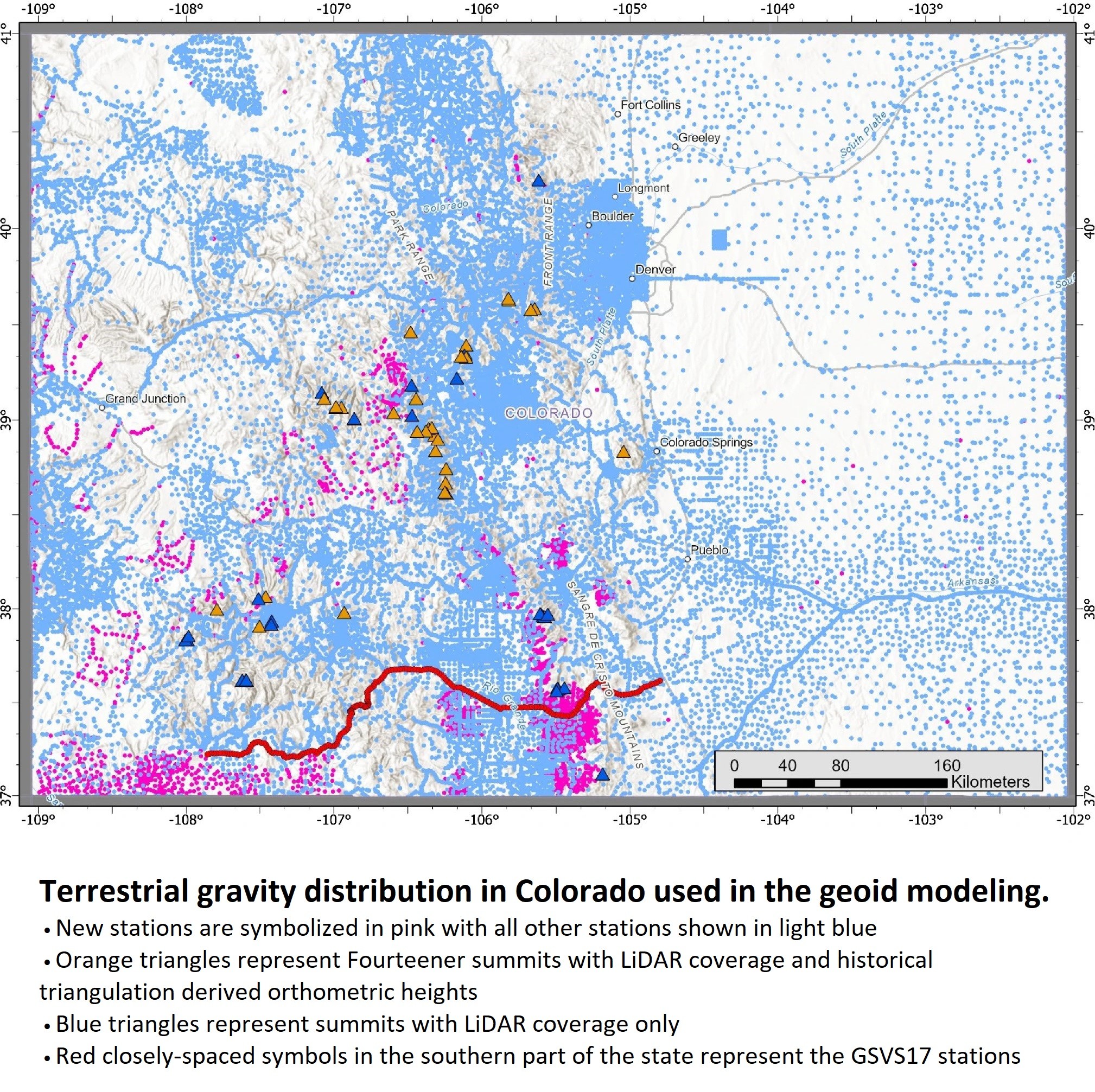
Moving Mountains - Reevaluating The Elevations Of Colorado Mountain Summits Using Modern Geodetic Techniques
--
https://doi.org/10.1007/s00190-024-01831-8 <-- shared paper
--
#GIS #spatial #mapping #NAVD88 #NAPGD2022 #Fourteeners #Colorado #elevation #3dep #geoid #mountains #mountain #orthometric #gnss #model #modeling #3dmodeling #numericmodeling #geostatistics #LiDAR #ellipsoidal #gravity #geopotential
@USGS @ngs
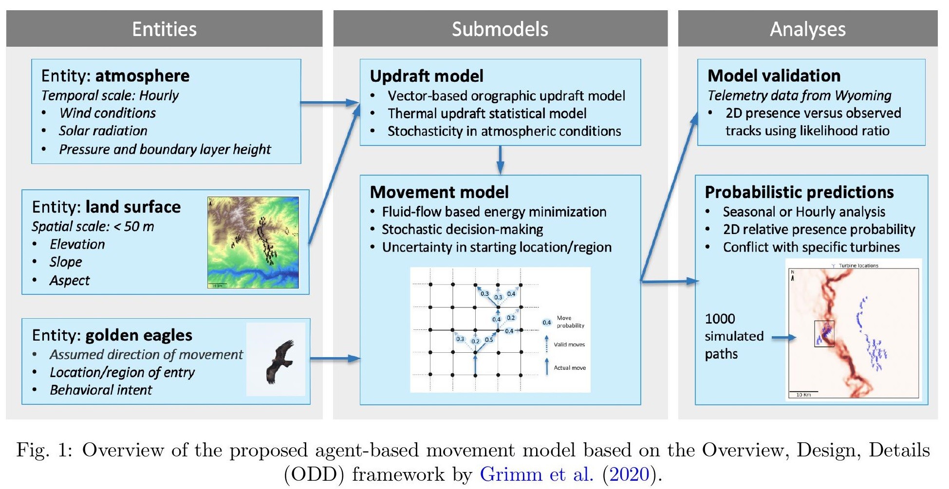
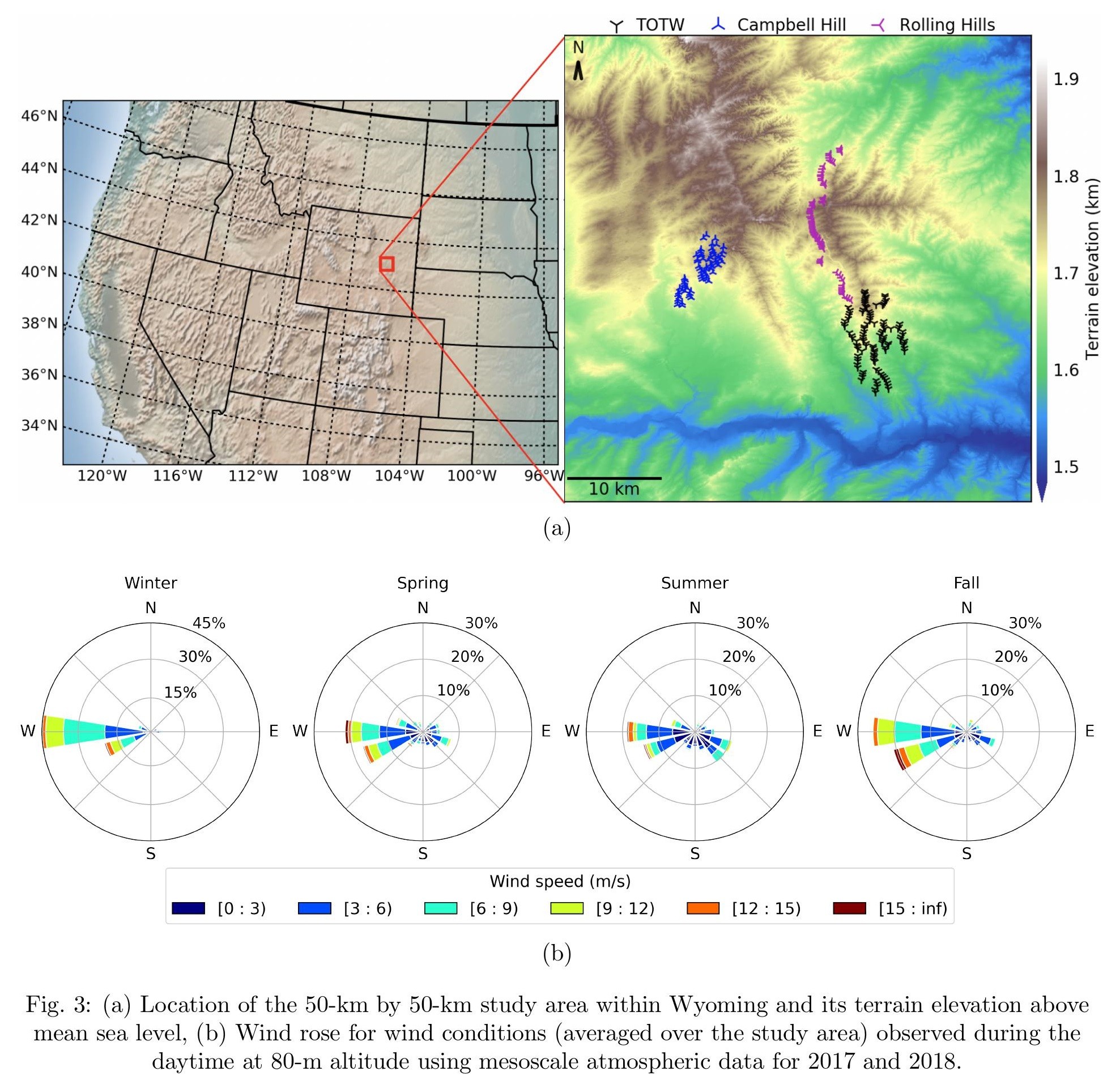
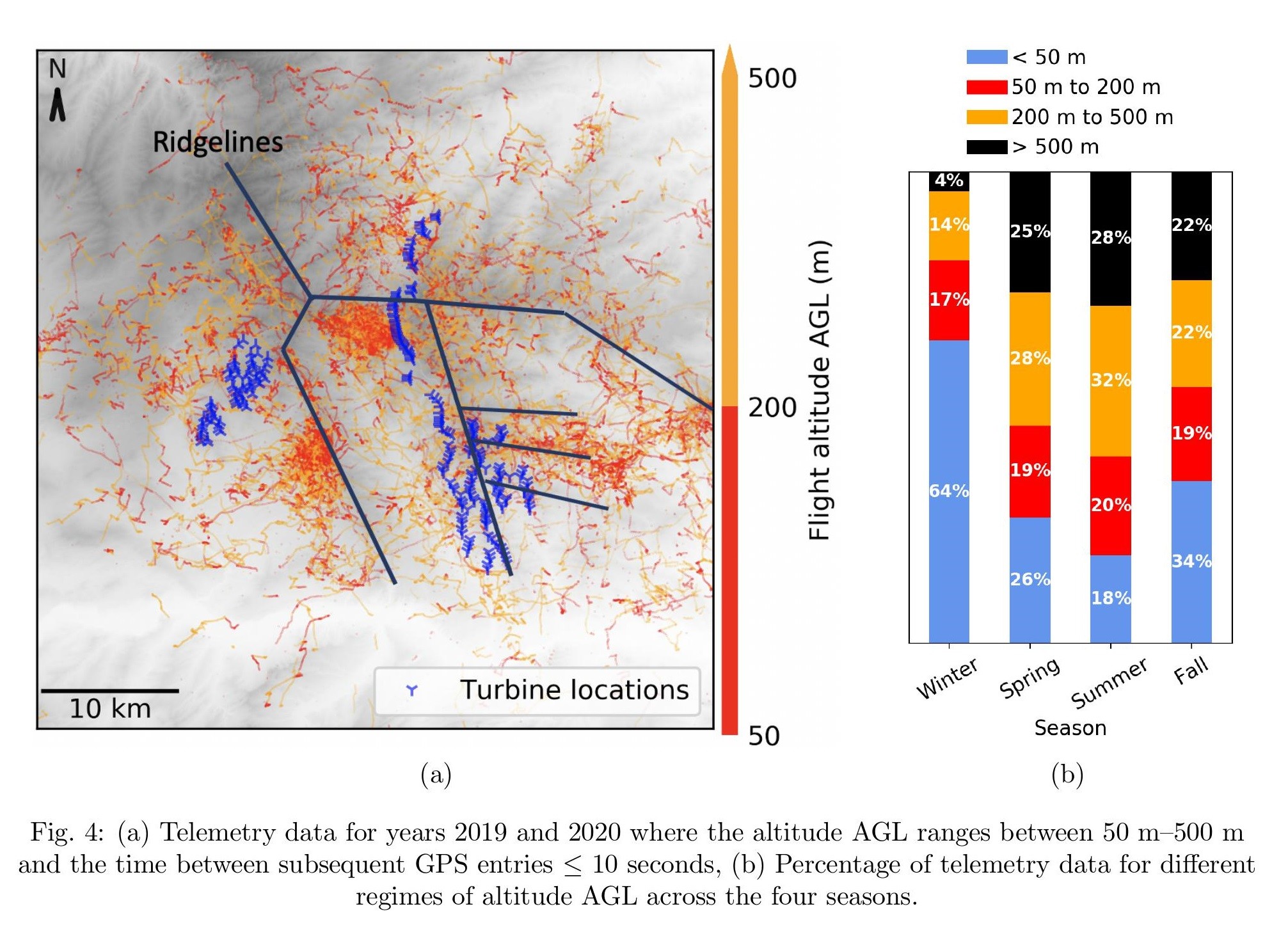
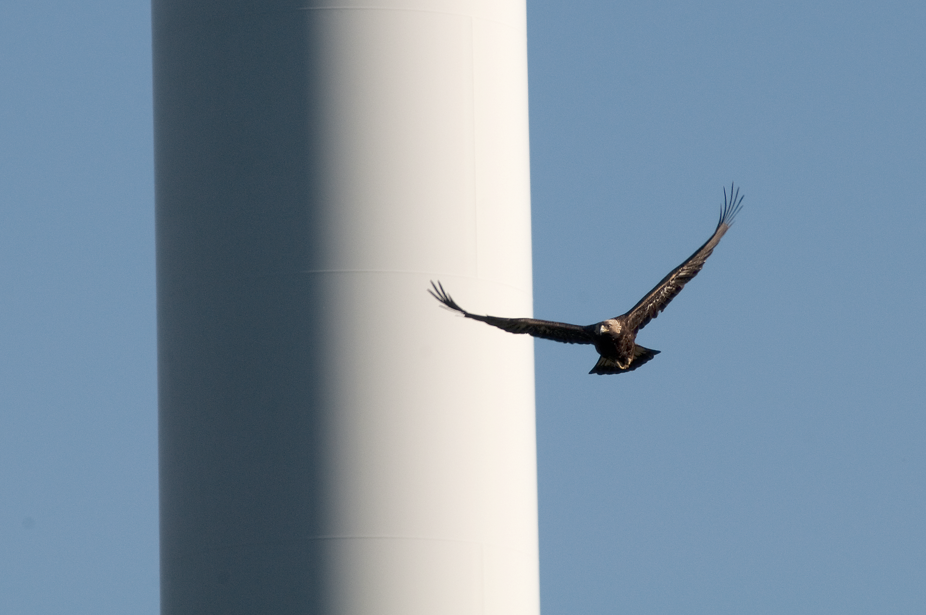
Stochastic Soaring Raptor Simulator (SSRS)
--
https://github.com/NREL/SSRS <-- shared GitHub repository
--
https://doi.org/10.1016/j.ecolmodel.2022.109876 <-- shared paper
--
#GIS #spatial #mapping #remotesensing #birds #eagles #soaring #raptors #windenergy #windturbines #model #modeling #numericmodeling #elevation #opendata #3dep #stochasticmodel #impacts #raptorstrike #3d #orographic #spatialanalysis #spatiotemporal #elevation #DEM #wind #weather #climate #SSRS #updraft #USWTDB #USGS #NREL #terrain #altitude #slope #aspect