#AppliedScience

Die Forschende Hochschule HofHomeOfResearch@wisskomm.social
2025-06-05

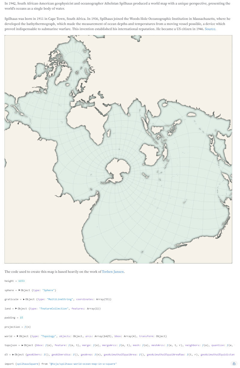
🧪 Now we’re talking – Episode 5:
Meet the gel permeation chromatograph! This machine helps us understand how big (or small) molecules really are 🧬 — and plays a key role in basic research at Hof University of Applied Sciences.

🔗 t1p.de/dz3ut

#dieforschendehochschulehof #hierwirdknallhartgeforscht #ScienceMastodon #LabTalk #MolecularScience #Chromatography #ResearchTools #AppliedScience

Picture of GPC and Johannes Küfner with short informations about the machine. The machine is supervised at the Institute for Circular Economy of Bio:Polymers (ibp) by Johannes Küfner and Benedikt Hiller, both research assistants, David Krieg, deputy research group leader and Lucas Großmann, deputy head of the institute.
2025-05-30

Wanna use computer vision for more than image rendering?

Pre-print alert: we published on arxiv our preprint on building FEA-compatible voxel-based RGB+Thermal 3D models, effectively bridging computer vision and simulation in one framework (arxiv.org/abs/2504.04448).

While there is still some limitations to this work (e.g. related to surface reconstruction) I hope this work can be the catalyst to more research in using computer vision in #AppliedScience !

👩‍🔬 Thanks to all the co-authors: Etienne Chassaing, Florent Forest, and Olga Fink.

See some teaser images from the paper, where we run FEA on a 3D model built from computer vision without post-processing!

#computervision #fea #simulation #voxel #thermal #sustainability

The images shows a table of the results over multiple dataset. Comparing thermoxel to plenixel it shows that thermoxel is able to generate geometrically correct meshes and that finite elements analysis can be run on the meshes without pre processing
💧🌏 Greg CocksGregCocks@techhub.social
2025-05-23

Clark Center For Geospatial Analytics’ Role In Our Seafood Sustainability Is Anything But Shrimpy - Decade-Old Aquaculture Project Has Received Over $7.5 Million In Grants From The Moore Foundation
--
clarku.edu/news/2025/05/08/cla <-- shared technical article
--
[this should not (necessarily) be considered an endorsement of the mentioned organisations]
#GIS #spatial #mapping #shrimp #shrimpfarming #Costco #remotesensing #earthobservation #machinelearning #AI #appliedscience #usecase #sustainability #production #productivity #aquafarming #aquaculture #seafood #mangrove #ecosystems #wetlands #coast #coastal #spatialanalysis #farming #agriculture #Indonesia #Thailand #Cambodia #Vietnam #Burma #Ecuador #SEAsia #SouthAmerica #landchange #landcover #change #university #education #research #appliedresearch

💧🌏 Greg CocksGregCocks@techhub.social
2025-05-14

The Feasibility Of Using LiDAR-Derived Digital Elevation Models [DEMs] For Gravity Data Reduction
--
usgs.gov/3d-elevation-program/ <-- shared article
--
pubs.usgs.gov/publication/ofr2 <-- shared report
--
“A nice report from our colleagues in the USGS Mineral Resources Program on the feasibility of lidar-derived DEMs, including 3DEP data, for gravity data reduction…”
#GIS #spatial #mapping #3dep #elevation #fedscience #remotesensing #earthobservation #gravity #submetre #accuracy #precision #dGNSS #GNSS #global #navigation #satellite #GPS #LiDAR #DEMs #gravimetrics #milligals #Bouguer #anomaly #monitoring #corrleation #refinement #datareduction #appliedscience #usecases
@USGS

💧🌏 Greg CocksGregCocks@techhub.social
2025-01-22

Digital Transformation In GIS & Hydrology
--
youtu.be/hz4g491uync?si=2g8TV9 <-- shared video interview
--
It was a pleasure to do this interview...
[Note: this was NOT as a representative of my employer, rather as a professional in this area]
#GIS #spatial #mapping #usecase #opendata #appliedscience #alldataisspatial #evolvingsystems #water #hydrology #video #interview
@BimTube | @GregCocks

splash screen - BimTube video interview - Digital Transformation In GIS & Hydrology with Greg Cocks
Victoria Stuart 🇨🇦 🏳️‍⚧️persagen
2024-12-27

How a fox skull shape conquers the snow
npr.org/2024/12/27/nx-s1-52333

* pointy shape of fox's snout makes it particularly adept at diving headfirst into snow

Effect of skull morphology on fox snow diving
pnas.org/doi/10.1073/pnas.2321

Penetration of fox & human skulls into granular matter: Oversimplifying a complex phenomenon?
pnas.org/doi/10.1073/pnas.2410

Secrets Of Snow-Diving Foxes
npr.org/sections/krulwich/2014

youtube.com/results?search_que

💧🌏 Greg CocksGregCocks@techhub.social
2024-07-03

History of GIS - Video – CGIS, The First Operational GIS, Canada [1967]
--
youtu.be/3VLGvWEuZxI?si=dp64Np <-- shared video
--
en.wikipedia.org/wiki/Canada_G <-- Canada GIS wiki page
--
“Early [1967] video description of the first operational GIS, the Canada GIS. The "father of GIS," Roger Tomlinson is highlighted. It is also an excellent description of how GIS operates today although the technology is considerably more advanced than when CGIS was first developed…”
#GIS #spatial #mapping #topology #cartography #spatialanalysis #gischat #appliedscience #solutions #history #canada #RogerTomlinson #CGIS #CanadaGeographicInformationSystem #CanadaLandInventory #canadaday

💧🌏 Greg CocksGregCocks@techhub.social
2024-06-07
Chart showing phases of data acquisition, processing, and delivery to partners and the public for the 3D Hydrography Program (3DHP). The phases are similar to those used for the 3D Elevation Program (3DEP). USGS, U.S. Geological Survey.cover - USGS Circular 1519 - The 3D National Topography Model Call For Action—Part 1. The 3D Hydrography Programschematic & text - 3D National Topography Modelscreen shots - the 3dhp_all service layers shown in desktop GIS software
Metharkmethark
2024-06-06

Let's be clear about one thing here: The Scientific Method is: Theoretical Proposal, Experimentation, Undisputed Factual Result (Applied Science) - Besides that, is guesswork.

💧🌏 Greg CocksGregCocks@techhub.social
2024-05-30

Greg Cocks - Digital Transformation in GIS and Hydrology [BimTube vodcast]
--
youtu.be/hz4g491uync?si=-zIsfo <-- link to BimTube vodcast
--
[speaking as a spatial data and applied science professional, NOT a USGS representative]
Thank you again Steven E. for the opportunity…
#GIS #spatial #mapping #DigitalTransformation #GISInnovation #HydrologyInsights #research #SpatialDataScience #EnvironmentalMonitoring #OpenDataChallenges #LiDARMapping #DigitalTwins #AppliedScience #podcast #vodcast #usecase #evolvingtechnologies
@BimTube

screen shot - BimTube opening splash screen with @GregCocks guest
💧🌏 Greg CocksGregCocks@techhub.social
2024-05-30

QGIS Plugin To Schedule School Hours Around Rain In Africa [podcast]
--
thegeomob.com/podcast/episode- <-- link to GeoMob podcast
--
[heck of a use case, the noise from heavy rain on metal roofs prevents kids from hearing the lessons]
#GIS #spatial #mapping #usecase #opensource #opendata #Africa #education #qgis #plugin #rain #rainfall #noise #distraction #school #schoolhours #subsaharan #spatialanalysis #spatiotemporal #appliedscience #Finland #OSM #openstreetmap #openscience #Geomob #podcast
@geomob

photo - schoolchildren around laptop, Africaphoto - teacher at blackboard, computer class, Africaphoto - new design of classroom, Burkina Faso, Africaphoto - heavy rain on roof
💧🌏 Greg CocksGregCocks@techhub.social
2024-05-17

Joe Davies - Data Visualization & GIS At Eurostat. Exploring New Ways Of Making Maps
--
observablehq.com/@joewdavies <-- link to a portfolio
--
I don’t know Joe, but I came across Joe’s work in my role as a geologist (the world topobathy image), and I was impressed so I sought out more; I think you will be impressed as well… [not considered a specific endorsement though, just my personal opinion, you know the drill]…
#GIS #spatial #mapping #cartography #usecase #appliedscience #visualisation #mapmaking #automation #code #api #webapps #spatialanalysis
@joewdavies

map and code screen shot - spilhaus projectionanimated representation (in original) - world's earthquakesscreen shot - Joe W Davis' home pagemap - global - world topobathy visualisation
💧🌏 Greg CocksGregCocks@techhub.social
2024-05-08

Presentation - Digital Earth: Groundwater, Colorado’s Hidden Treasure - Denver Museum Of Nature & Science
--
dmns.org/visit/events-and-acti <-- DMNS events page
--
An excellent and engaging presentation at the Denver Museum Of Nature & Science (DMNS); I love seeing use cases, adaptation, data being used to make things better, faster, stronger, more efficient - especially in the context of climate-change-related challenges and vulnerabilities.
--
#GIS #spatial #mapping #visualisation #storytelling #presentation #waterresources #water #hydrology #usecase #appliedscience #remotesensing #earthobservation #watersecurity #Denver #Colorado #Kansas #Nebraska #waterrights #interstatecompacts #irrigation #groundwater #climatechange #farming #agriculture #precisionagriculture #efficiency #imagery #spatialanalysis #geology #hydrogeology #domestic #watersupply
Denver Museum of Nature & Science | Robert Raynolds | Ka Chun Yu

photo - planetarium - digital earth groundwater opening titlephoto - outside Denver Museum Of Nature & Science, elephant at the west entrance, near sunsetimage - groundwater decline, map, ogallala aquiferphoto - centre pivot irrigation with inset of cell phone apps to help manage
💧🌏 Greg CocksGregCocks@techhub.social
2024-04-30

Types Of Remote Sensing - Devices And Their Applications [broad overview]
--
eos.com/blog/types-of-remote-s <-- shared technical article
--
[sharing of this blog post should not be considered an endorsement of this company]
#GIS #spatial #mapping #remotesensing #earthobservation #overview #tutorial #instrumentation #satellite #devices #implementations #radar #laser #sensors #usecase #appliedscience #RADARSAT #TerraSARX #SRTM, #EOSDA #ERS #Sentinel #LANDSAT #insar #ifsar #LiDAR

image - Scheme of how active remote sensing worksimage - Scheme of how passive remote sensing workssatellite imagery examplesatellite imagery example

Client Info

Server: https://mastodon.social
Version: 2025.04
Repository: https://github.com/cyevgeniy/lmst